
Next tropical cyclone renamed to avoid clash with PM Anthony Albanese
The Bureau of Meteorology has had to make a rapid change as two potential tropical cyclones loom off Australia’s coast.
Environment
Don't miss out on the headlines from Environment. Followed categories will be added to My News.
Two tropical cyclones could form near Australia in the next few days - but the next to develop will not be known by its planned name.
The next tropical cyclone to develop was supposed to be named ‘Anthony’, following Tropical Cyclone Zelia in Western Australia last week.
However the Bureau of Meteorology has this week changed the name to avoid any confusion with Prime Minister Anthony Albanese.
The next cyclone to form will instead be known as ‘Alfred’.
“When a name matches a prominent person of the time, we reorder to the next name starting with that same letter to avoid any confusion,” a bureau spokesperson said.
This follows the tradition or naming cyclones by alternating alphabetically between female and male names.
With two tropical cyclones brewing off Australia’s shores, Alfred may eventuate in the next week.
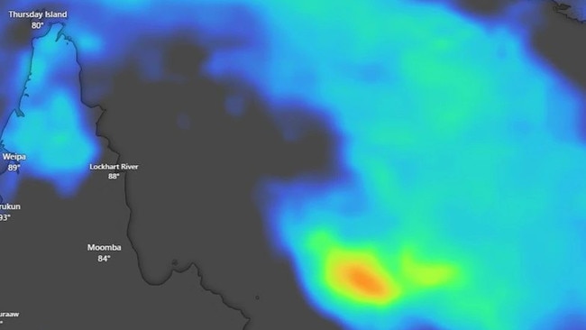
A tropical low has developed about 400km northeast of Cairns in the Coral Sea.
Heading into Saturday, the chances of the low forming into a tropical cyclone are moderate and from Monday they increase to high.
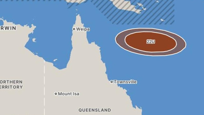
While the tropical low is expected to further develop in the following days, it does not post an immediate threat to Queensland as of Friday.
“(The tropical low) will remain well offshore and move to the east and southeast over the next seven days,” Bureau of Meteorology senior meteorologist Jonathan How said.
From the middle of the week, the bureau said there were numerous scenarios for the movement and development of the tropical low or cyclone.
“This includes moving further east and away from Australia towards places like New Caledonia and Vanuatu, or the system could reach further south over the Coral Sea,” Mr How said.
Queenslanders are urged to stay up to date with the latest tropical cyclone information.
The second tropical low that could emerge as a cyclone is sitting over the Indian Ocean.
It is well off the West Australian coast but does have a moderate chance of developing into a tropical cyclone.
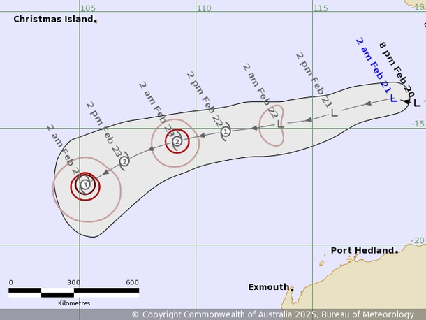
As of Saturday, the chance increases to high, but the bureau said the system would remain offshore of WA and weaken over open waters.
“There is no treat to Western Australia or any offshore territories,” Mr How said.
For the country’s east, there is a break in the cooler weather with a burst of heat hitting as we head into the weekend.
“We’ll see a run of very hot days and also some very warm nights,” Mr How said.
This is due to a high pressure system in the south of the country.
“That’s directing warmer northerly winds over Victoria, South Australia and Tasmania,” Mr How said.
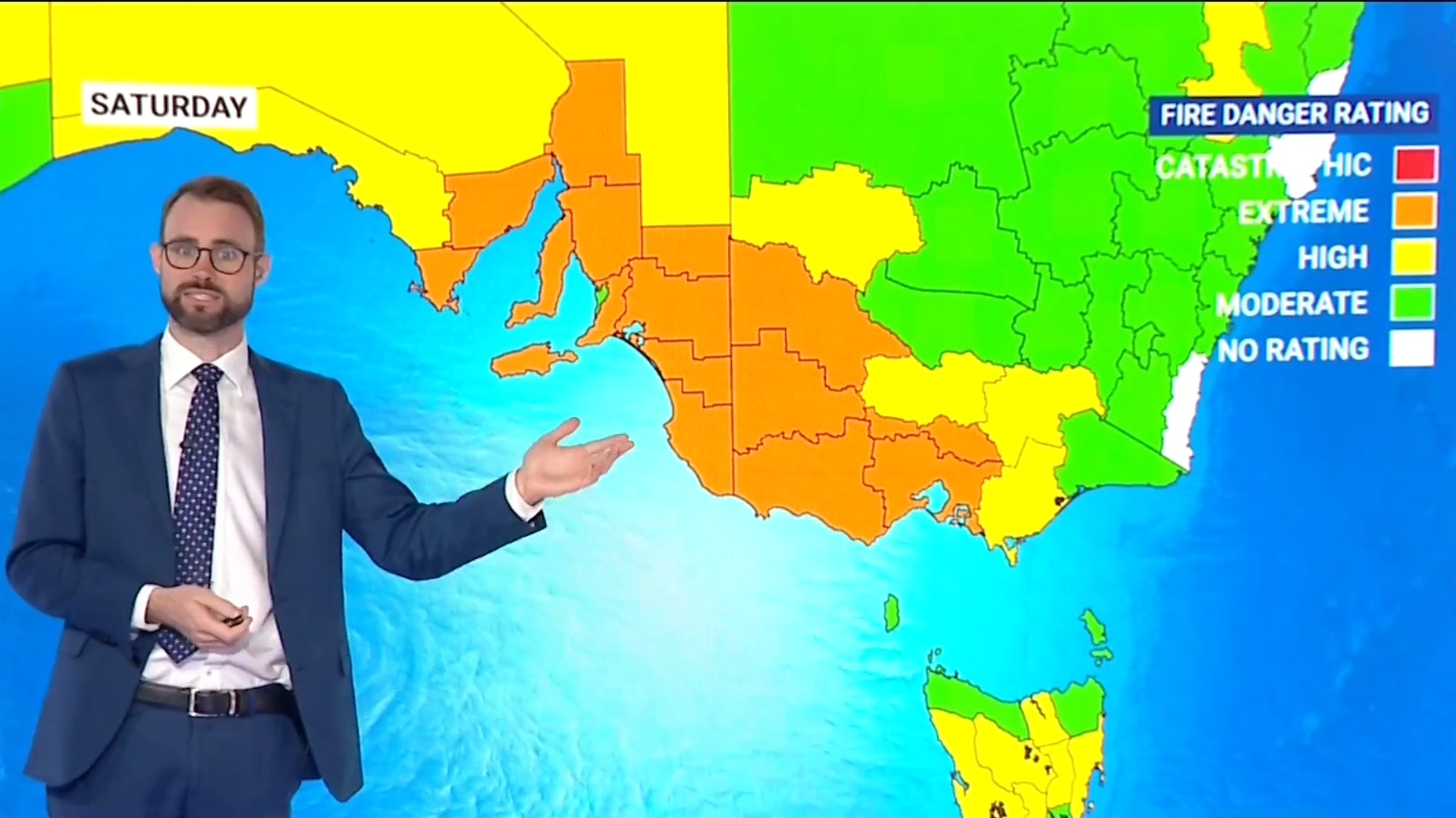
While warmer weather may be welcome, it does bring with it an elevated fire danger.
A key feature of the heatwave is very strong and gusty winds, according to the bureau.
“These winds will combine with these high temperatures to produce elevated fire danger,” Mr How said.
Winds will strengthen on Saturday afternoon for South Australia and during the evening for Victoria and Tasmania.
It remains windy into Sunday, with warnings for possibly damaging winds.
Fire dangers have increased from Friday but do reach extreme levels on Saturday for much of southeastern South Australia and western and central Victoria, including the Mount Lofty Ranges and Melbourne.
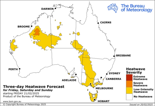
Even with cool changes expected on Sunday, a high fire danger remains across large parts of Tasmania, South Australia and Victoria.
In the coming days, coastal areas in South Australia and Victoria will experience temperatures in the high 20s with inland reaching low to mid 30s, while Tasmania remains at a cooler 21C.
The maximum temperatures on Friday will be 31C in Melbourne and 33C in Adelaide.
The heat is set to peak on Saturday for these areas, bringing sun and wind.
Temperatures of mid to high 30s will be felt in large parts of Victoria, South Australia and NSW, with some inland areas reaching the low 40s.
And Tasmania’s temperatures will jump into the high 20s to low 30s.
On Saturday, Aussies can expect highs of 37C in Melbourne, 38C in Adelaide and 30C in Hobart.
Sydney is also expected to warm up, with temperatures forecast to reach high 20s to low 30s from Saturday.
Originally published as Next tropical cyclone renamed to avoid clash with PM Anthony Albanese

PM’s $500m pledge for local jobs
The Prime Minister has announced a crucial investment package during a pre-election speech, but not before he took a few healthy swipes at the opposition.
‘Flesh, fat’: Vile Aussie beach scenes
Locals claim pristine Tasmanian beaches are being overrun by a disgusting “biohazard”, sparking outrage and urgent calls for action.