
North Queensland faces fresh flood warnings as ‘life-threatening’ rainfall smashes state
Residents in North Queensland have been urged to stay safe as another barrage of rain is set to hit, leaving already saturated areas at risk of further flooding.

Environment
Don't miss out on the headlines from Environment. Followed categories will be added to My News.
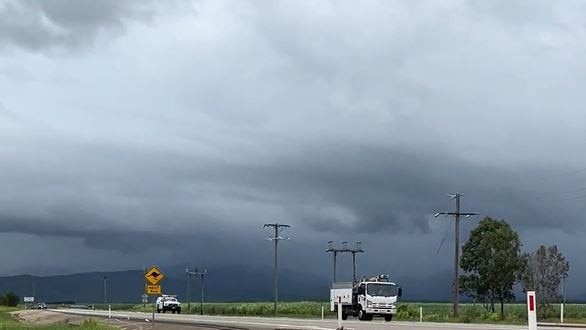
Queenslanders are facing another day of intense and potentially life-threatening rain as an active monsoon trough travels east.
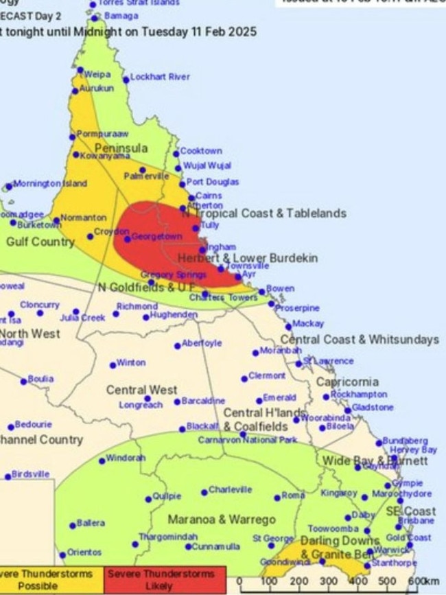
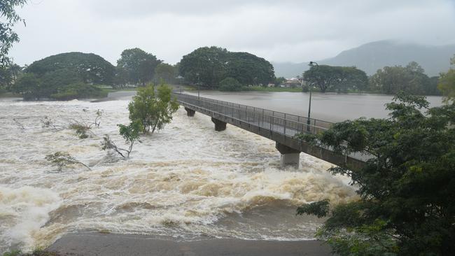
The Bureau of Meteorology have issued a severe weather warning for Herbert, Lower Burdekin, Peninsula, Gulf Country, North Tropical Coast and Tablelands, Northern Goldfields and Upper Flinders Forecast Districts, with further rainfall threatening to smash the regions already soaked from the deluge of flooding last week.
BOM senior meteorologist Angus Hines told NewsWire the wet conditions have “kicked up” on Monday evening and Tuesday morning.
Residents in Northern Queensland can anticipate another day of deluge as rainfall continues to smash the “completely saturated” grounds, leaving the overrunning water with “nowhere to go” and worsening the “already swollen” grounds.
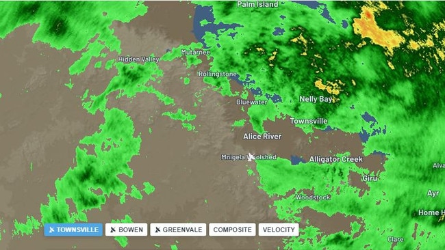
The highest rainfall totals were “storm-driven”, Mr Hines said, with 196mm recorded in Rollingstone, 155mm in the Upper Black River, 141mm in Paluma and 134mm at Paradise Lagoon.
A severe thunderstorm warning was issued for residents between Croydon to Ayr, likely bringing heavy-to-intense rainfall and damaging winds with it.
The storm could also hit regions in the northwest, spanning from Weipa to Charters Towers and the southeast interior.
“Grounds are wet and catchments are swollen,” Mr Hines said.
“So any further rainfall we see will lead to a swift response from rivers and increased risk of river flooding and riverine flooding.”
BOM general manager Matt Collopy warned the rainfall was only going to become more intense on Tuesday, with some areas already breaking their monthly rainfall records in the past 10 days.
“The rainfall is really being driven in the higher context by a low embedded within the monsoon trough” he told the Courier Mail.
“Rainfall totals in 24 hours associated with this low are expected to reach 100 to 250 millimetres in 24 hours, with possible falls up to 300 millimetres through to Tuesday.
“Warnings for both the flooding, as well as that severe weather warning are likely to change quickly and evolve over the next couple of days.”
Renewed major flooding may occur along the Haughton River as localised heavy rainfall is forecast for the area.
“The Haughton River at Giru is likely to exceed the minor flood level (1.80m) Tuesday morning,” the bureau said.
“Localised areas of heavy rainfall may cause renewed river level rises to the major flood level (2.50m) over the next few days.”
Thankfully, Mr Hines told NewsWire the rain should start to ease from Wednesday, with the flooded areas potentially “drying up completely” by Thursday.
Thousands of residents have been impacted by blackouts for several days, with Ergon Energy working to restore power for towns and regions cut off due to the floods.
“While we’re relieved more than 99 per cent of homes and businesses in the disaster zone are finally restored, we’re acutely conscious of the disappointment and frustration of those who aren’t,” an Ergon Energy statement read.
“There’s no restoration option that hasn’t been considered. We’ve tried by ground, sky and over water.
“We’ll continue tackling these last and toughest challenges tomorrow. We know power is critical to recovery, and a return to some sense of normalcy, and we won’t ease up until it’s back for everyone.”
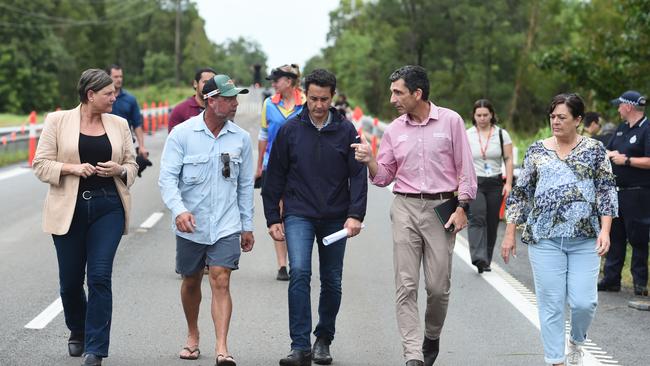
On Tuesday morning, Queensland Premier David Crisafulli said residents in North Queensland were “very resilient” and “tough”, with the government focusing its energy into recovery for those affected by the floods.
“Resilience doesn’t mean they should be left on their own,” Mr Crisafulli told the ABC.
“That’s why we’re pitching in hard and making sure we do all we can to get them back on their feet.”
Mr Crisafulli urged residents on Saturday to remain connected and continue to work together through the floods.
“The Risk of widespread heavy rainfall has reduced but there is still the prospect of those monsoonal bursts and we saw them overnight,” he said.
There are major flood warnings remain for the Flinders, The Murray, Herbert, Haughton and the Burdekin Catchment regions.
“There remains the prospect of rivers continuing to rise and fall and therefore the road situation remains very volatile,” Mr Crisafulli said.

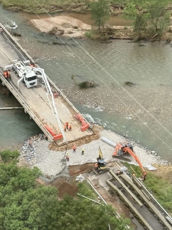
Mr Crisafulli also addressed temporary and immediate support measures for flood victims in Ingham.
Floodwaters rushed through the North Queensland town burying the local bridge out as well as cutting off power and phone lines.
After a temporary bridge was installed as part of phase one, Mr Crisafulli said the region was moving onto the next phase of the plan which includes repairing the bridge.
“We are hopeful if in the first half of next week the road will be open again to traffic,” he said.
“To think we had a bridge washed away, hanging by a thread and in less than a week has seen an immediate solution is quite frankly amazing.
“It will give the town that next ray of hope.
“That immediate solution enabled the emergency service vehicles to go in. The temporary solution will enable life to return to normal.
“Then the permanent solution of long-term, stronger, higher and better [bridge].”
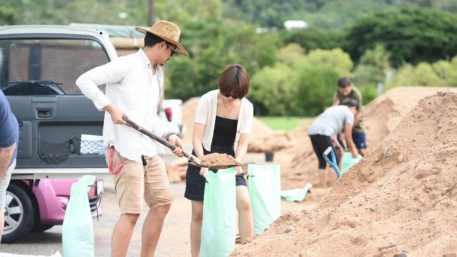
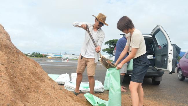
The pledge to build back comes as the already sodden parts of North Queensland are expecting even more rain throughout the weekend and into Monday.
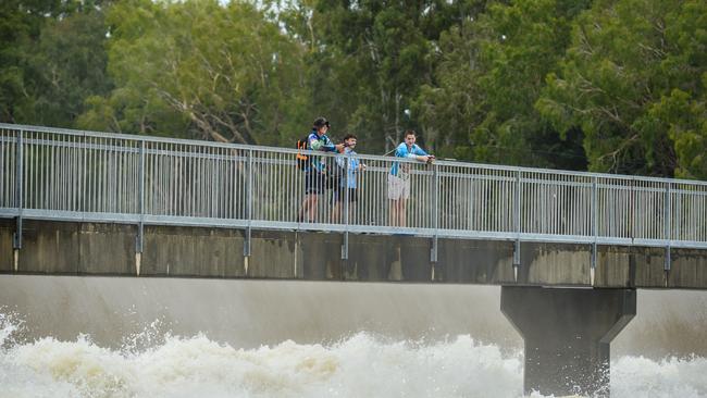
Queensland Police issued a fresh emergency warning on Saturday morning for a major flood at the Haughton River at Giru, located near Townsville.
The Bureau of Meteorology has advised the current level is 2.93m and may reach 3m today.
The peak flood height earlier this week hit 3.13m.
The police are urging locals near the flood area to move to higher ground.
The Bureau of Meteorology warned a strengthening monsoon trough lingering across northern parts of Queensland would drive the intensification of rainfall in tandem with a tropical low off the coast.
The Whitsunday Coast airport cancelled all flights on Friday due to forecast heavy rainfall.
High weekend totals and another severe weather warning delivers a fresh blow for residents who have battled wild weather all week.
Coles has announced it is delivering 180 pallets of stock to Cairns stores this morning as roads reopen.
While the situation could change with the weather, Coles said it is working to get supplies to impacted customers.
“We want to reassure everyone that our teams are working tirelessly to keep stock moving into our stores. We are exploring every possible option to get deliveries into Cairns, whether by road, air or sea,” Coles Queensland regional manager Brad Stewart said.
“We thank our truck drivers, store team members, supply and transport teams as well as local authorities for working together to get food to our communities.”
Earlier in the week residents in North Queensland were struggling to find supplies in the local Woolworths and Coles.
Officials have urged residents not to bulk-buy food and essential items.
Forecaster Weatherzone has described the week’s deluge as a “one-in-2000 year” event, with numerous locations between Townsville and Cairns receiving around 1500 millimetres of rain within three days, resulting in major flooding, widespread evacuations, and two flood-related deaths.
“The monsoon refers to the seasonal reversal of the wind pattern over northern Australia, where the dry east to south-easterly winds that dominate for much of the year are replaced by west to north-westerly winds,” Weatherzone meteorologist Ben Domensino said.
“This rain may cause further flooding in areas of northern Qld that are still reeling from the immense rainfall totals that occurred over the past couple of weeks.”
“Active phases of the monsoon can also enhance the likelihood of tropical lows and tropical cyclones near Australia.”
Originally published as North Queensland faces fresh flood warnings as ‘life-threatening’ rainfall smashes state
Gross reason fans locked out of pop star gig
Fans of a pop-rock icon have been left out in the cold after a nasty issue forced a much-anticipated concert to be cancelled.

Top 10 Aussie beaches revealed
Move over Bronte and Byron Bay, Australia has a new best beach according to the national tourism council