
Australian spring weather outlook: Drier and hotter as the country punished by climate drivers
The BOM has made its predictions for the weather in spring, and one meteorology map should concern just about everyone.

Environment
Don't miss out on the headlines from Environment. Followed categories will be added to My News.
The outlook for spring weather is set to be “very different” from last year, the Bureau of Meteorology has warned in its seasonal forecast.
With the continent stuck between two rain-suppressing climate drivers, September to December is forecast to see below average rainfall and “unusually” dry conditions across essentially the whole country.
That could be bad news for farmers and will lead to an increased risk of bushfires.
And there’s one map released by the bureau in its spring climate outlook this week which paints a punishing picture for the season ahead with every capital city affected.
It comes as Australia exits a winter which will most likely have been the warmest for more than a quarter of a century.

The last three months have been drier than usual, with rainfall down nationally by eight per cent. It would have been even more parched but for a spell of unseasonal rain in the centre of the country in late June and early July.
Winter’s overall mean temperature was 1.54C above average for Australia – the highest it’s been since 1996.
“Spring is also likely to bring warmer days and reduced rainfall,” BOM senior climatologist Lynette Bettito said.
“This is very different to last year’s weather forecast for spring, which was the second wettest spring on record.”

Australia in climate driver pincher
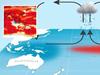
What’s causing these conditions is two opposing climate drivers on opposing sides of Australia.
To the west, the Indian Ocean Dipole (IOD) is in positive mode. That means there are warmer seas towards Africa and cooler seas near Indonesia which has the effect of lessening rainfall for southern and central Australia.
To the east, El Nino conditions are ramping up. It’s already been called by US meteorologists but the BOM, which has a different calculation of El Nino, has yet to officially announce it.
Nonetheless, the dial pointing towards El Nino has a similar result to the positive IOD – cooler waters and hotter conditions towards Australia lowering likely rain levels but this time in the east.
Climate change also plays a role exacerbating these naturally occurring conditions. For instance, July was the warmest month globally since records began.
“A warmer climate increases the risk of extreme weather like heatwaves,” Ms Bettito said.

Dry winter
Looking in more detail at spring, rainfall is likely to be far below average across most of Australia.
Southwestern parts of Western Australia, Victoria and parts of Queensland could see 80 per cent less rain than usual for winter.

Only northwest WA, hardly the most moist part of Australia, could see average conditions.
The first rains of the Top End’s wet season may be delayed, further limiting the amount of precipitation over the season as a whole.
That could see soils drying out over winter.
However, water storage levels remain high over much of Australia – many are 90 per cent full – because of the wet weather prior to summer.

BOM’s worrying weather map
There’s one map in the BOM’s outlook that is particularly troubling.
The forecast for maximum daytime temperatures for the next three months is just an expanse of unrelenting red.
What that signifies is that there is an 80 per cent chance that the hottest part of the day during spring will be warmer than the average.
Included in that is every capital city, from Darwin down to Hobart, and Sydney across to Perth.

Only the Cape York Peninsula and southwest Tasmania could see conditions similar to usual.
Another map shows there is an increased chance of unusually warm temperatures particularly in inland NSW and much of WA.
Overnight winter is also likely to be warmer than usual in most areas, with the exception of Adelaide, the Top End and coast of central and Far North Queensland.

Bushfire risk increased
And of course, none of this bodes well for bushfires as Australia’s run of sodden years comes to a likely end.
The outlook from the Australian Fire Authorities Council shows an increased bush fire risk across much of southern and central Queensland, northern and central NSW including coastal areas, the central Northern Territory and parts of South Australia and Victoria.
“There’s always a risk of dangerous and destructive fires in Australia during spring,” Ms Bettito said.
“With warm weather, grasses can quickly dry out and increase the risk of fast moving fires, including their urban areas.
“Now is the time to prepare and review your bushfire plan wherever you are.”
Originally published as Australian spring weather outlook: Drier and hotter as the country punished by climate drivers

Millions brace for brutal cold snap
Residents in the southern part of Australia should rug up extra warm this weekend as a cold snap settles in, bringing lashings of rain and damaging wind.

Delays as Bali flights resume after volcanic eruption
A volcanic eruption in Indonesia has disrupted travel for more than 14,000 passengers with delays and backlogs still expected.