
Bohle Bridge partially closes after near-record breaking rainfall soaks NQ
Townsville’s rainfall records could tumble with heavy rainfall expected all week, creating chaos on the roads with closures. Find out the latest and who got the rain.
Townsville
Don't miss out on the headlines from Townsville. Followed categories will be added to My News.
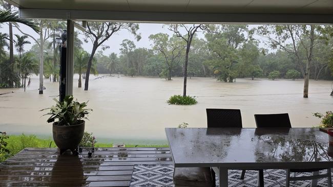
With more heavy rain expected this week, Townsville is on the verge of smashing its March and annual rain record, with the drenching leading to traffic chaos around the region.
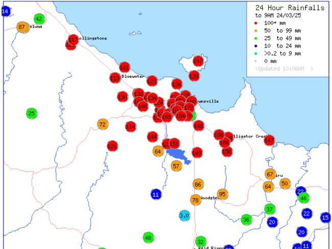
The Bureau of Meteorology confirmed on Monday morning that its gauge at the Townsville Airport had recorded 624mm in March – just 50mm off the monthly record of 696mm from 2011.
Since 9am on Sunday, triple-figure rainfall totals have been recorded throughout the Townsville region, led by Alligator Creek with 185mm and Annandale with 184mm.
BOM meteorologist Livio Regano expected Townsville’s annual rainfall record of 2300mm to be shattered over the coming days or weeks, given that the present total was hovering around 2000mm.
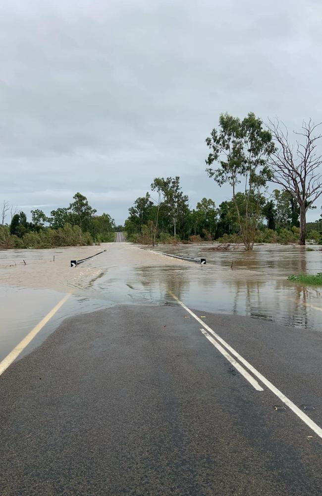
The heavy rain led to severe traffic jams throughout Townsville’s northern suburbs on Monday morning when the rising Bohle River forced the lower Bohle Bridge to be closed, placing additional pressure on a traditionally congested section of the Bruce Highway.
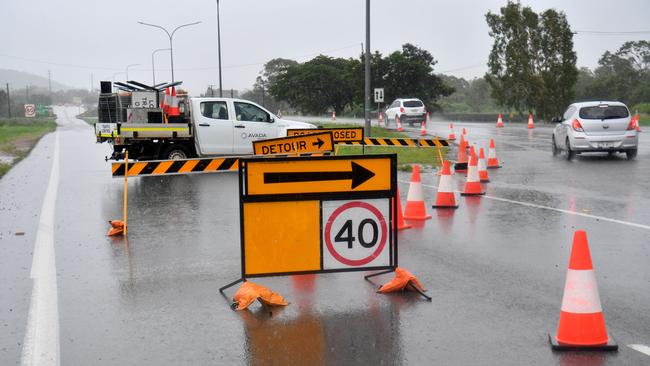
The Queensland Traffic website had several locations listed that were impacted by flooding.
At Cosgrove, there was water over the road and a diversion in place, directing traffic onto the single lane Upper Bohle Bridge.
As a consequence, witnesses reported seeing peak hour traffic jams stretching for kilometres in the area on Monday morning.
There was water over the road, blocking traffic in both directions on the Woodstock Giru Rd at Mount Surround/Woodstock.
A full closure of the causeway at Allambie Lane in Rasmussen was due to the Bohle River flooding.
To the north, the Ingham area has several roads closed to traffic including Orient Rd, Pomona Rd, Pinnacle Hill Rd, Cemetery Rd, Newtons Crossing Rd, Stone River Rd, Hawkins Creek Rd,
West of Townsville, the Gregory Developmental Rd was closed at Einasleigh / Mount Surprise, while the Kennedy Developmental Rd was also impacted in two locations near Lyndhurst.
Locals urged to stay alert
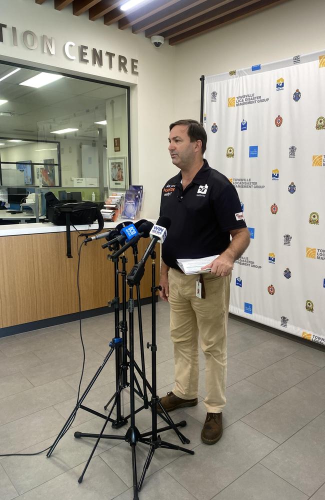
Chair of the Townsville Local Disaster Management Group and councillor Andrew Robinson said on Monday afternoon that locals should remain up to date with the disaster dashboard, due to the “uncertainty” around the weather system.
“The things that we are asking people to do at this stage is to be alert, but don’t be alarmed,” he said.
“We are asking people to stay alert to SMS messages that may come through on their systems.”
Sand and sandbags are available from Lou Litster Park, the Dam, the corner of Bruce Highway and Mount Low Parkway and Bluewater Community Centre.
Not wanting locals to become complacent after previous weather events, Cr Robinson urged anyone who was thinking of getting sandbags to get them earlier rather than later.
“Some people may say that we are over exaggerating, but again, I would much rather be overprepared and people be safe than be underprepared and put lives at risk,” he said.
Area controller for the Northern region of the SES, John Forde said locals should take the time to check their gutters, sandbag their homes and prepare for potential flooding.
Having received over 4000 in recent months, Mr Forde said the SES should be the first point of call for any storm damage, trees down or flooding, but said triple-zero should be the go-to for life threatening situations.
Having been active since late January, Mr Forde commended the volunteers who have been travelling around the state assisting.
Acting chief superintendent Chris Lawson stressed the message of “if it’s flooded, forget it”, and said police have been sent out to numerous calls for help, most recently on Sunday evening where a person was stuck in floodwaters in their car but was able to escape without injury or the help of the SES swift water rescue team.
“Those issues continue to arise and place unnecessary risk on police or even the swift water rescue people that have to undertake those rescues,” he said.
Weather forecast for Townsville region
Mr Regano said the wet weather was being generated by a tropical low that was positioned south east of Mount Isa, with the broad system covering Queensland with cloud, stretching all the way south to Sydney.
“This monsoonal low … is drawing a lot of tropical air down from the north, and it’s colliding with the south easterly trade winds coming from the opposite direction and the collision line, what we call the convergence line, last night happened around about Townsville,” Mr Regano said.
“Now that line can move and shift and change over days, but in general, it’s that Herbert Burdekin area that looks like it’s in the main firing line over the next few days.
He anticipated heavy falls to occur on the east between Cooktown and Mackay, with even heavier falls expected inland “because it’s not a coastal driven system”.
“We’re forecasting we could easily get 60 to 80 millimetres daily for the next week, but it’s possible to get isolated falls above 200 millimetres in a 24 hour period over this next week,” Mr Regano said.
“Not everyone’s going to get that amount. The chances that (200mm) lands on Townsville airport is pretty slim.
“It’s continuous heavy showers (with) breaks in between, but there’ll be quite substantial deluges, and that’ll last at least until the end of this week.”
Townsville was expected to receive 15mm to 80mm of rain on Tuesday, 5mm to 70mm on Wednesday, 7mm to 80mm on Thursday, and 7mm to 60mm on Friday.
Even on the weekend, he was expecting “substantial showers” to deliver 30-40mm a day.
Given that the region’s catchments were already soaked, he warned that further rain would lift river levels.
On Monday, the BOM updated its minor flood warnings for the Ross and Herbert Rivers, while the Bohle River had a moderate flood warning.
Who got the rain
• Alligator Creek 185mm
• Annandale 184mm
• Aitkenvale 179mm
• The Lakes 170mm
• Aplin Weir 167mm
• Mysterton 166mm
• Black Weir 163mm
• South Townsville 160mm
• Vincent 157mm
• Kirwan 153mm
• Garbutt 151mm
• Stuart 151mm
• Cungulla 147mm
• Deeragun 143mm
• Toolakea 140mm
EARLIER:
Townsville and the surrounding region are facing another soaking, with forecasters warning of persistent rain and renewed flood risks following an already waterlogged week.
Senior Meteorologist Miriam Bradbury from the Bureau of Meteorology said saturated catchments and sodden ground mean any further rainfall could have a greater impact.
“The catchments are saturated, and the ground is really wet. Any further rain that falls is going to have a more sensitive impact,” Ms Bradbury said.
Rainfall totals over the past seven days have been extraordinary, with South Townsville receiving 638mm, Townsville Aerodrome 559mm, and Ingham Aerodrome 678mm. Ingham Depot recorded 569mm, Ingham Pump Station 510mm, while Charters Towers saw a significantly lower total of 39mm.
“The wettest days were obviously Tuesday, going into Wednesday morning, and Wednesday going into Thursday morning,” Ms Bradbury said.
While rainfall varied widely across the region, most areas recorded well over half a metre of rain, prompting minor flood warnings for the Bohle and Ross Rivers, which remained in place on Sunday.
The heavy falls have already taken a toll, with the Star River Bridge on Hervey Range Road at Dotswood suffering significant damage after being submerged during last week’s flooding. Though emergency repairs were carried out on Sunday, motorists travelling between Townsville and Greenvale were forced to make a four-hour detour via Charters Towers along the Gregory Developmental Road.
But Ms Bradbury warned that North Queensland is not out of the woods yet, with more rain forecast for the week ahead.
Showery conditions are expected to continue, particularly along the coastal strip between Ayr and Innisfail, which is tipped to receive the heaviest falls.
“By the end of the week, fairly widespread rain is expected right across these areas,” she said.
Her advice to residents is to stay informed and up to date of the latest alerts.
“Keep an eye on the warnings yourself. Keep an eye on the radar each day. Keep an eye out for thunderstorm warnings too, because they are likely to change as this situation unfolds.”
Originally published as Bohle Bridge partially closes after near-record breaking rainfall soaks NQ
Join the conversation

‘Protector and a backbone to all who loved him’: Cowboys foundation player remembered
The North Queensland Cowboys have expressed sorrow over the passing of a foundation player Robert Piva, a tough former Zealand and Western Samoan international. READ THE TRIBUTES.
Read more

NAMED: Man charged with sexual assault at massage business
A Burdekin man charged with sexually assaulting women at a massage business can finally be named after his matter appeared in an Ayr court.
Read more