
Bureau of Meteorology issues severe weather and flood warnings throughout NQ
Heavy rain is continuing to threaten NQ, with the Bureau of Meteorology issuing a severe weather warning and flood warnings for multiple rivers. Read the latest update.
Townsville
Don't miss out on the headlines from Townsville. Followed categories will be added to My News.
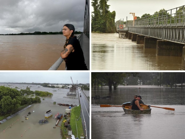
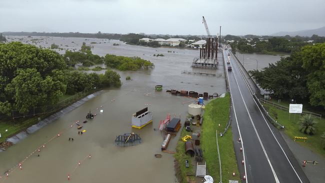
North Queensland is bracing for more severe weather and flooding after a fresh round of warnings were issued on Tuesday morning.
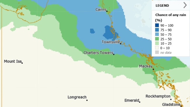
Flash flooding was once again possible on Tuesday as the trough extends from the Gulf of Carpentaria to the tropical east coast near Townsville, threatening to bring heavy rain to already soaked areas and lift river levels.
Bureau of Meteorology general manager Matt Collopy warned the trough continued to drive the risk of heavy rain for flood-affected areas between Townsville and Cardwell.
He said some areas had likely already broken monthly rainfall records in the past 10 days, with several locations receiving more than 1500mm in this time.
“The rainfall is really being driven in the higher context by a low embedded within the monsoon trough,” he said.
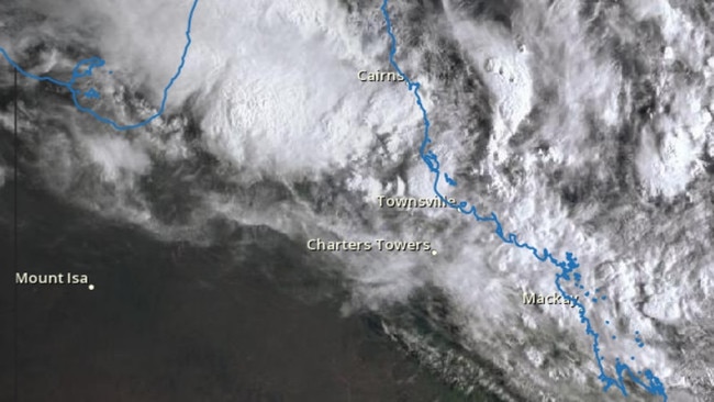
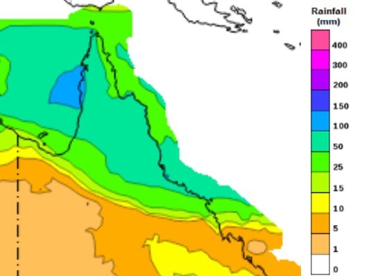
“That low is currently sitting near the Gulf Country near Normanton, (and) is expected to move east tonight (Monday) to around Georgetown and then further east on Tuesday towards the Townsville coastal area.
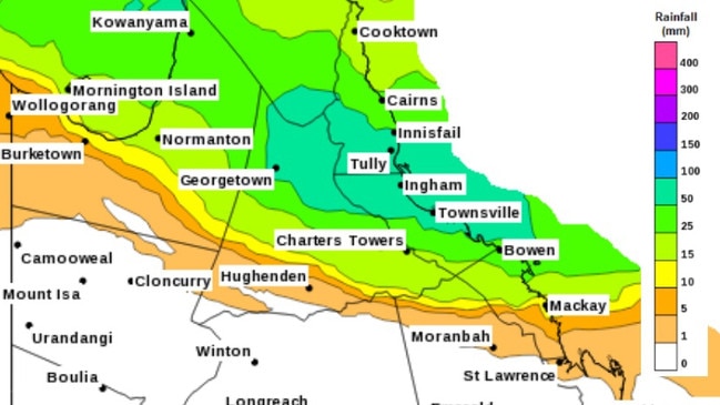
“Rainfall totals in 24 hours associated with this low are expected to reach 100 to 250 millimetres in 24 hours, with possible falls up to 300 millimetres through to Tuesday.
“Warnings for both the flooding, as well as that severe weather warning are likely to change quickly and evolve over the next couple of days.”
Mr Collopy said the low was not likely to form into a tropical cyclone as it moved east off the Queensland coast, with a significant decrease in rainfall for affected areas by Wednesday.
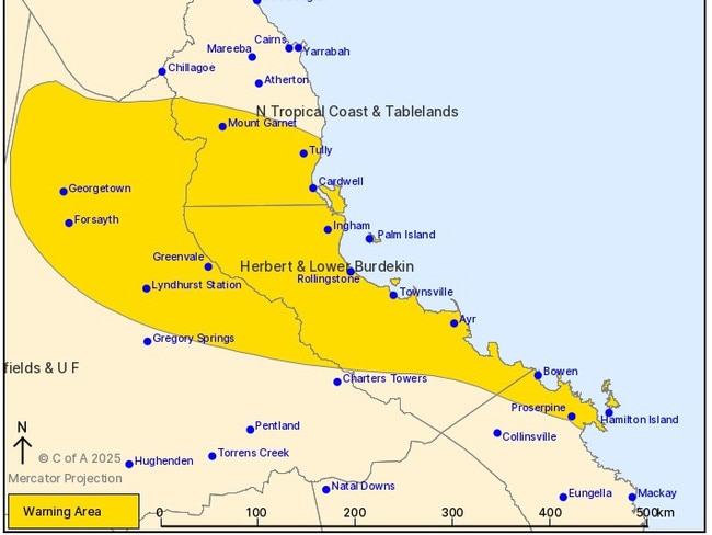
Severe weather warning for North Queensland
A severe weather warning was issued by the Bureau of Meteorology at 4:33am for heavy, locally intense rainfall impacting on the Herbert and Lower Burdekin and parts of North Tropical Coast and Tablelands, Northern Goldfields and Upper Flinders.
Locations which may be affected include Townsville, Georgetown, Ingham, Ayr, and Bowen.
“Significant rainfall continues about northern Queensland until early Wednesday, with a low over the Gulf Country embedded in the monsoon trough, expected to move slowly east over the Northern Goldfields and Upper Flinders on Tuesday,” the BOM said.
“Enhanced rainfall due to widespread showers and isolated embedded thunderstorms is possible early this week, with extremely wet soils and river catchments leading to a higher than normal vulnerability to flash flooding.”
For the Northern Goldfields and Upper Flinders, heavy rainfall which may lead to flash flooding was forecast on Tuesday with six-hourly rainfall totals between 100 to 150mm possible. Isolated 24-hour rainfall totals up to 200mm were also possible.
In the North Tropical Coast and Herbert and Lower Burdekin, there was the potential for stronger showers and thunderstorms to produce localised heavy to locally intense rainfall which may lead to dangerous and life-threatening flash flooding, continuing Tuesday morning. Six-hourly rainfall totals between 120 to 180mm were possible, as were isolated 24-hourly rainfall totals up to 250mm possible, especially over the Cassowary and Townsville coasts.
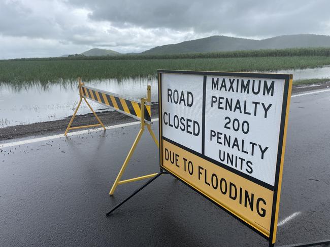
Heavy rainfall increases the potential for landslides and debris across roads.
The rainfalls were expected to ease across the warning area from early Wednesday morning.
Pace Road Rollingstone has recorded 188mm since 9am on Monday, while Upper Black River collected 155mm.
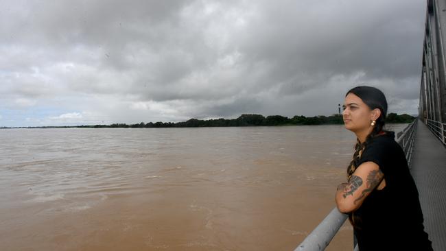
North Queensland’s flood warnings
Burdekin River
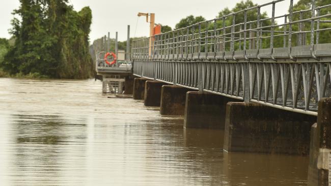
There is a major flood warning for the Cape and Upper Burdekin Rivers and moderate flood warning for the Lower Burdekin and Suttor Rivers.
In its latest flood warning on Tuesday at 5:34am, the BOM said major flooding was easing at Sellheim (Macrossan Bridge) along the Upper Burdekin River where the river level may fall below the major flood level during Tuesday morning.
Renewed rises were occurring at Burdekin Falls Dam where moderate flooding was expected to continue during Tuesday.
Moderate flooding is expected to continue downstream of the dam until at least Wednesday. Moderate flooding is expected to continue at Inkerman Bridge with a moderate flood peak during Tuesday.
Major flooding was expected to continue along the Cape River at Taemas during Tuesday.
Suttor River at St Anns may fall below the moderate flood level during Tuesday morning.
Further rainfall and the chance of thunderstorms were forecast for the next few days, which were likely to prolong flooding during this week.
A Severe Weather Warning is current for Herbert and Lower Burdekin, and parts of North Tropical Coast, Tablelands, Northern Goldfields, Upper Flinders, Central Coast and Whitsundays Forecast Districts.
Belyando and Suttor Rivers to Burdekin Falls Dam: Moderate flooding is occurring along the Belyando and Suttor Rivers to Burdekin Falls Dam.
The Suttor River at St Anns is currently at 6.7m and falling, above the moderate flood level (6.5m). The Suttor River at St Anns may fall below the moderate flood level (6.5m) Tuesday morning.
Cape River to Burdekin Falls Dam: Major flooding is occurring along the Cape River to Burdekin Falls Dam.
The Cape River at Taemas is currently at 9.21m and falling, above the major flood level (8m). The Cape River at Taemas is expected to remain above the major flood level (8m) during Tuesday.
Burdekin River to Burdekin Falls Dam: Major flooding is occurring along the Burdekin River to Burdekin Falls Dam.
The Burdekin River at Sellheim is currently at 15.95m and falling, above the major flood level (15m).
The Burdekin River at Sellheim may fall below the major flood level (15m) Tuesday morning.
The Burdekin River at Burdekin Dam is currently at 6.58m and steady, above the moderate flood level (5.50m).
Renewed rises were occurring at Burdekin Dam where the river level may reach around 6.7m Tuesday morning, with moderate flooding.
The reservoir level is expected to remain above the moderate flood level (5.5m) during Tuesday.
Burdekin River downstream of Burdekin Falls Dam: Moderate flooding is occurring along the Burdekin River downstream of Burdekin Falls Dam.
The Burdekin River at Dalbeg is currently at 18.23m and rising, above the moderate flood level (15m).
Renewed rises are occurring at Dalbeg where the river level may reach around 18.40 metres Tuesday afternoon, with moderate flooding.
The river level was expected to remain above the moderate flood level (15m) until Wednesday.
The Burdekin River at Clare is currently at 14.65m and rising, above the moderate flood level (13m).
Renewed rises are occurring at Clare where the river level may reach around 15.20m Tuesday evening, with moderate flooding.
The river level is expected to remain above the moderate flood level (13m) until Wednesday.
The Burdekin River at Inkerman Bridge was estimated to be approximately 10.7m around 7.05pm Monday and steady, above the moderate flood level (10m).
Renewed rises at Inkerman Bridge may reach around 11.2m Tuesday evening, with moderate flooding.
Further rises were possible with the forecast rainfall. The river level was expected to remain above the moderate flood level (10m) until Wednesday.
Haughton River
There was a major flood warning for the Haughton River catchment issued at 9.10am on Tuesday.
Renewed river and creek level rises were being observed across the Haughton River catchment following additional rainfall during Monday and early Tuesday morning.
A peak was expected to arrive at Giru on Tuesday afternoon, with a height slightly below the level of the peak observed on Saturday, February 8.
Further storms and periods of heavy rainfall were forecast across the Haughton River catchment during the remainder of Tuesday before easing during Wednesday.
The catchment remains wet and will respond to further rainfall.
Major Creek: Renewed rises were being observed along Major Creek, where minor flooding was occurring with further rises possible due to the forecast rainfall for the remainder of Tuesday.
Haughton River: Major flooding is likely along the Haughton River.
The Haughton River at Giru is currently at 1.98m and rising, above the minor flood level (1.8m).
The Haughton River at Giru is likely to exceed the major flood level (2.5m) late Tuesday morning.
The river level may reach around 2.8m Tuesday afternoon, with a height slightly below the peak observed on February 8. Further rises were possible with the forecast rainfall.
Ross River
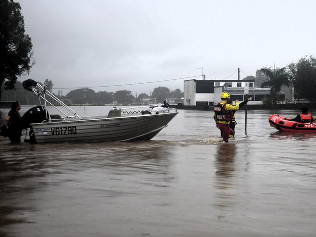
A moderate flood warning was issued at 5.15am on Tuesday for the Ross, Bohle and Black Rivers with further thunderstorms and periods of heavy rainfall forecast during the next few days.
Catchments remain wet from recent prolonged rainfall and minor flooding was occurring at Aplin Weir and Mt Bohle.
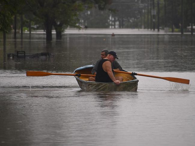
Any further localised heavy rainfall was expected to result in rapid river level rises and may lead to a return of more significant flooding across the Townsville area.
As advised by Townsville City Council, Ross River Dam will see controlled releases through the spillway which will contribute to flows downstream in the Ross River.
Ross River: Minor flooding was occurring along the Ross River, however, localised heavy rainfall may result in renewed moderate flooding.
The Ross River at Aplin Weir is currently at 1.21m and steady, above the minor flood level (1.1m), which was likely to remain above the minor flood level on Tuesday afternoon.
Further areas of localised heavy rainfall may cause renewed river level rises to the moderate flood level (1.6m) during the next few days.
Bohle River: Minor flooding was occurring along the Bohle River, however, localised heavy rainfall may result in renewed moderate flooding.
The Bohle River at Mt Bohle is currently at 4.16m and rising, above the minor flood level (4m) and was likely to remain above the minor flood level on Tuesday morning.
Further areas of localised heavy rainfall may cause renewed river level rises to the moderate flood level (5.50m) during the next few days.
Black River and Bluewater Creek: River and creek levels remain elevated across the Black River and Bluewater Creek catchments during Tuesday. The catchments will remain very responsive to any localised heavy rainfall over the next few days, with renewed rises possible.
Herbert River
A major flood warning was issued on Tuesday at 9.34am for the Herbert River.
The BOM said heavy rainfall had been observed across the Herbert River catchment since Saturday morning, particularly over the lower reaches of the catchment.
This rainfall has resulted in renewed river level rises and areas of minor to moderate flooding are occurring along the Herbert River, but at this stage, river levels were not expected to reach higher levels observed earlier this month.
Further heavy rainfall and thunderstorms were forecast for the remainder of Tuesday and into Wednesday.
Herbert River to Nash’s Crossing: Moderate flooding was expected to occur along the Herbert River to Nash’s Crossing.
No recent observations were available for the Herbert River at Gleneagle, but based on the nearby automatic gauge, the river level at Gleneagle was expected to be around the moderate flood level (8.5m) during Tuesday, with further rises possible due to forecast rainfall.
Herbert River downstream of Nash’s Crossing: Minor to moderate flooding was occurring along the Herbert River downstream of Nash’s Crossing, but a forecast showed localised heavy rainfall could result in renewed moderate to major flooding.
The Herbert River at Abergowrie Bridge is currently at 7.75m and rising, above the minor flood level (6m) and was expected to remain above the minor flood level during Tuesday.
The river level may reach the moderate flood level (10m) overnight Tuesday into Wednesday, with further rises possible with the forecast rainfall.
The Herbert River at Ingham Pump Station (alert gauge) is currently at 9.44m and rising, below the minor flood level (10m), which may exceed the minor flood level from late Tuesday morning.
Further areas of forecast heavy rainfall may cause further rises to around the moderate flood level (11m) overnight Tuesday into Wednesday.
The Herbert River at Gairloch (alert gauge) is currently at 8.89m and rising, below the minor flood level (9.5m) and may exceed the minor flood level from late Tuesday morning.
Further areas of forecast heavy rainfall may cause further rises to around the moderate flood level (10.5m) overnight Tuesday into Wednesday.
The Herbert River at Halifax is currently at 4.91m and rising, above the moderate flood level (4.50m) and may reach the major flood level (5m) from late Tuesday morning.
Further rises were possible with the expected rainfall.
More Coverage
Originally published as Bureau of Meteorology issues severe weather and flood warnings throughout NQ
Join the conversation
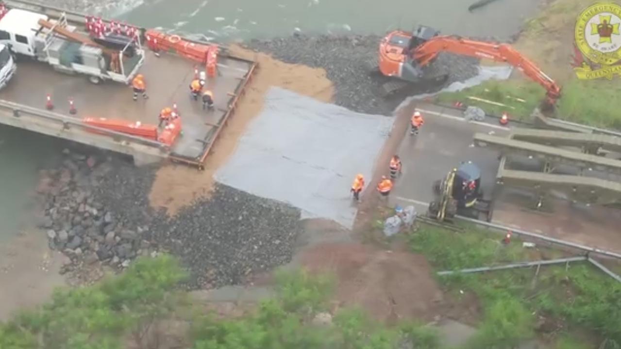
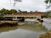
Now open: Ollera Creek bridge open to all traffic
A vital bridge connecting flood ravaged communities has officially been opened to the public, after previously only being available for freight, supply and emergency vehicles.
Read more

Qld tourism haven officially a hotspot for shark catches
Queensland’s most sharky beach has been revealed in the wake of the Sunshine State’s latest shark attack. SEE THE MAP
Read more