
Golden Age: Maps reveal the Gold Coast’s worst roads as they become more congested
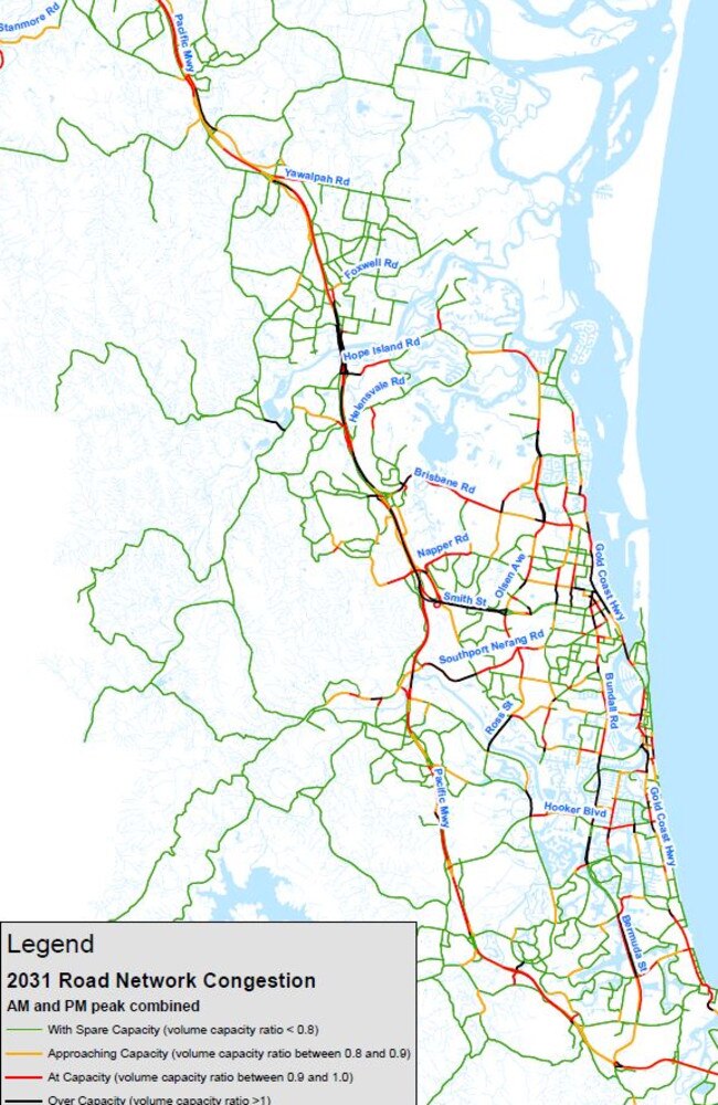
THE Gold Coast’s worst roads can now be revealed. New data showing what the city’s worst drives has been released and also show just how bad the city’s congestion will be by 2031. FULL LIST OF WORST ROADS.
Golden Age
Don't miss out on the headlines from Golden Age. Followed categories will be added to My News.
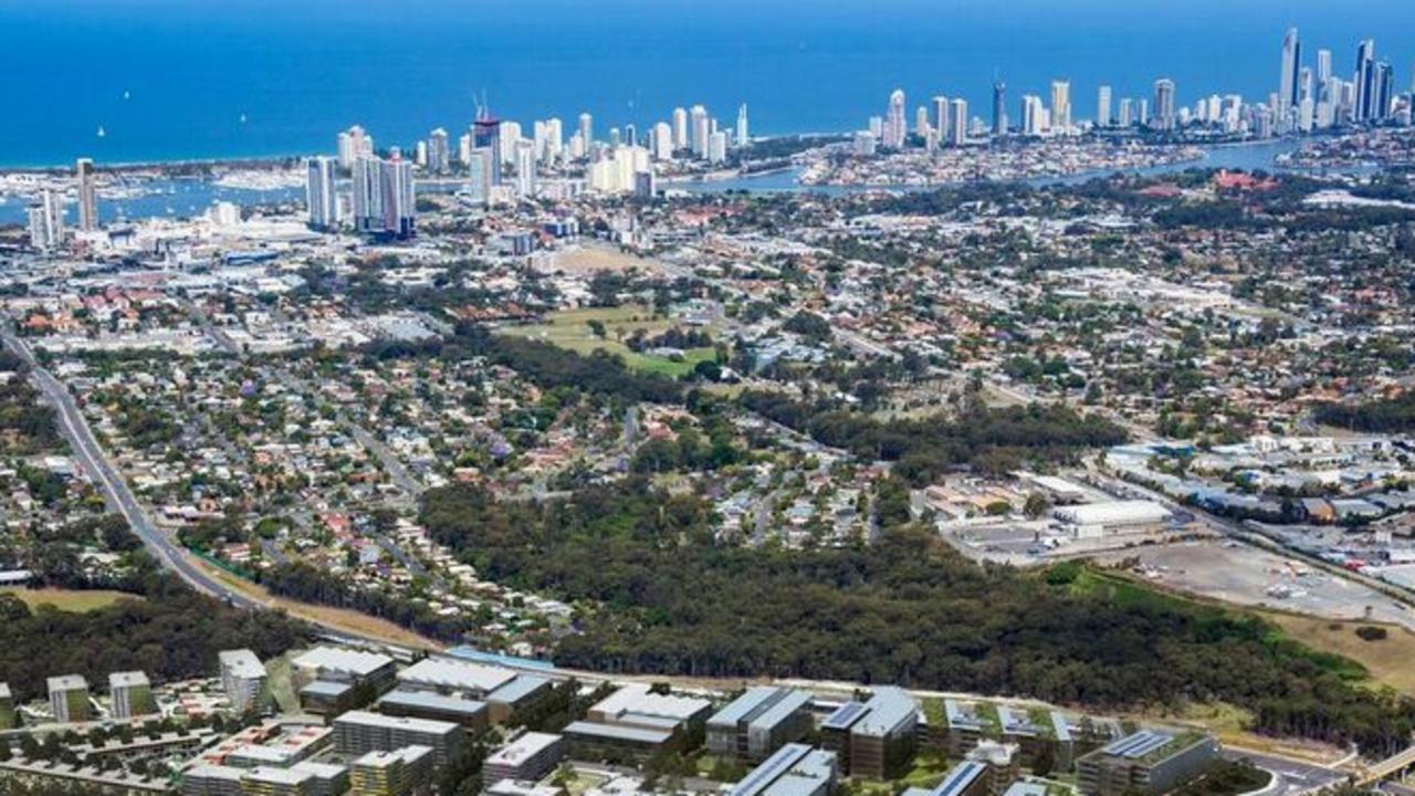
THE city’s major coastal highway and its east-west links are at bursting point and the entire network is destined to grind to a halt within 12 years.
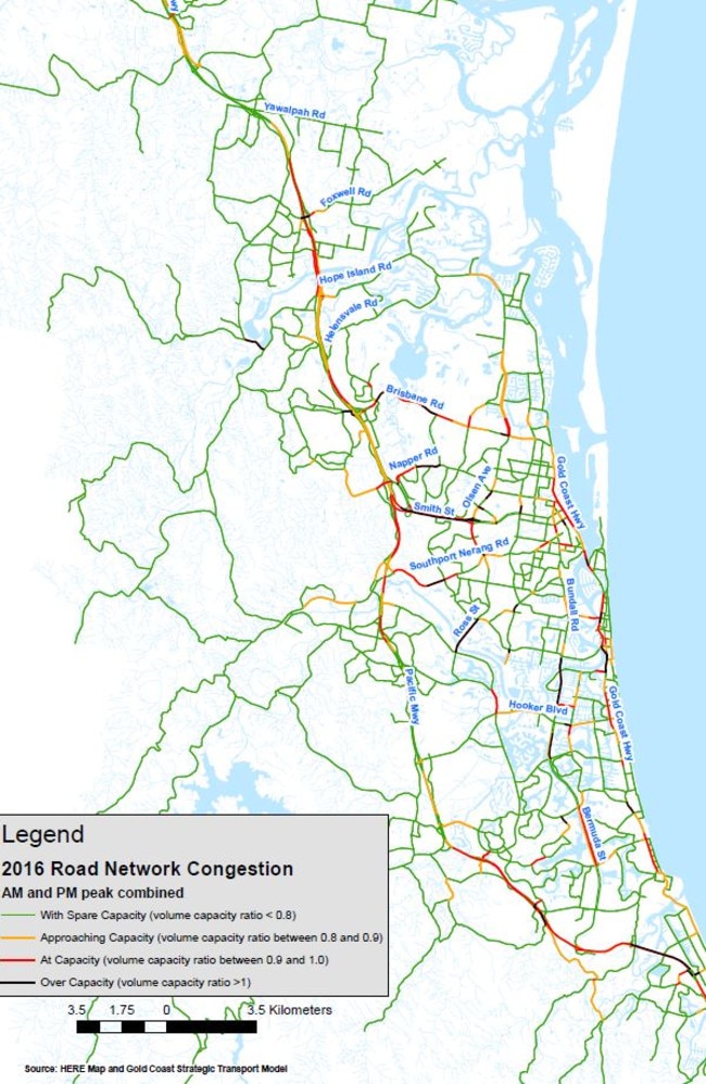
The Gold Coast Bulletin’s Golden Age campaign, council mapping and data from the government and RACQ shows for the first time the shocking extent of the city’s traffic congestion.
Respondents to the Golden Age survey regard the Gold Coast Hwy (29 per cent) as the city’s most shocking transport route, followed by Smith St (24 per cent), Bundall Rd (20 per cent) and Reedy Creek Rd (11 per cent).
GOLDEN AGE: TUNNEL PUSH TO SOLVE COAST’S TRAFFIC ISSUES
RACQ head of public policy Dr Rebecca Michael said major government funding had to be injected to ensure the city’s most congested roads did not clot.
“Higher traffic volumes are already being experienced around the Gold Coast, but specifically in the northern corridor which includes Ormeau, Pimpama and Helensvale,” Dr Michael said.
“Where higher traffic volumes lead to congestion there is typically an increased risk and number of crashes.”
In five years, 300 crashes occurred on the Pacific Motorway between Smith St Motorway and the NSW border, putting it in the high-risk AusRAP rating category for accidents per kilometre.
GOLDEN AGE: NEW ROAD NETWORK PLANNED FOR COAST SUBURBS
“When crashes occur here, congestion backs up for kilometres often grinding the nearby arterial roads like the Smith St Motorway to a halt,” Dr Michael said.
The state and federal governments last month agreed to cough up $2 billion to upgrade key M1 bottlenecks, but those works will not solve all traffic hotspots.
All divisional city councillors were asked to contribute and responses from seven – Donna Gates, Cameron Caldwell, William Owen-Jones, Peter Young, Glenn Tozer, Daphne McDonald and Dawn Crichlow – confirm the biggest challenge is the feeder roads connected to the M1 interchanges.
The other councillors did not reply.
GOLDEN AGE: WHAT GOLD COASTERS THINK OF THE M1
Cr Owen-Jones said the transport fix required co-operation between council and State Government with the priority being Exit 57.
“Exit 57, this has a knock-on effect to Oxenford Tamborine Rd, Hope Island and Dreamworld Parkway and the Old Pacific Hwy. All roads lead to Exit 57,” he said.
“I would prefer the State Government concentrate on an upgrade rather than a band-aid fix.”
Southern-based councillor Daphne McDonald nominated Exit 92 and Exit 85 and the feeder roads linked to the interchanges.
GOLDEN AGE: BUILD A BULLET TRAIN
“Palm Beach Ave and K.P. McGrath Drive go into that and it is an absolute bottleneck,” Cr McDonald said. “It is getting to the point where if you are coming at 10 in the morning it is choc a bloc. There is an impact on all the roads heading to the M1.”
Deputy Mayor Donna Gates said the priority was the on and off ramps and interchanges to the M1 at Exits 38, 41, 45 and 49.
“Without these improvements, duplication of local roads will still result in a bottleneck at the entries and exits to the M1,” she said.
Cr Gates listed several council-controlled roads where work was either progressing or required. These included Eggersdorf, Goldmine and Peachey roads at Ormeau and Yawalpah Rd at Pimpama.
The construction of a service road on the western side of the M1 connecting Rifle Range Rd North at Pimpama with Tillyroen Rd at Ormeau was major priority for northern Gold Coast.
Hinterland-based councillor Glenn Tozer nominated 10 roads in his division which either needed or were getting congestion fixes.
Work was continuing on Springbrook Rd and Beechmont Rd along with design plans on Tallai Rd and Old Coach Rd.
Cr Crichlow said the approach to Sundale Bridge continued to be a problem causing bingles.
Cr Caldwell said: “The M1 by far is the biggest issue in my division.”
Cr Young nominted five roads, including dangerous congestion hotspots such as the M1 off-ramp from Heslop Road into Binstead Way.
10 worst stretches of Gold Coast roads
* Gold Coast Highway — large coastal sections are at capacity, others cannot cope including the turn-off to Kirra, through the tourism heart of Surfers Paradise and just south of the Nerang River before Southport
*Smith Street — the stretch from Olsen Avenue west to the M1 is overcapacity and at a standstill at peak hour.
* Bundall Road — despite improvements in the northern section it is gridlocked in the south through Broadbeach Waters and Mermaid Waters, north and south of Hooker Boulevard.
* Reedy Creek Road — again has had upgrades but unable to cope with east-west traffic through to Burleigh
* Yalwalpah Road — rated by motorists as our slowest road in fastest-growing area at Pimpama with waits of up to 35 minutes.
* Foxwell Road — a nightmare dog track east of an upgraded M1 interchange as work continues next to it on the Coomera Town Centre.
* Brisbane Road — the eastbound exit at Helensvale off the M1 quickly slows to crawl as motorists make their way past the Coombabah wetlands.
* Napper Road — the section west from Olsen Avenue is at capacity with a large chunk in between around the primary school and medical centre over capacity.
* Palm Beach Ave and KP McGrath — Exit 93 off the M1 at Elanora is a notorious bottleneck with lengthy delays reaching the highway.
* Exit 57 on the Pacific Motorway — leads either west to Oxenford or east to Hope Island and cannot cope with traffic.
‘Still more work to be done on Coast’
CITY leaders have confirmed the city’s future is bright after the Bulletin’s Golden Age campaign — but there’s still work to be done. Here’s what they said.
Coast in its prime, ready for more
THE Gold Coast is in a state of prosperity and transformation, writes Annastacia Palaszczuk. But there’s more to come for the growing city.