
Tropical Cyclone Kirrily expected to form overnight, make landfall Thursday night
Tropical Cyclone Kirrily is now expected to make landfall as a Category 2, bringing destructive winds and potentially life-threathening flash flooding to much of the state.
QLD News
Don't miss out on the headlines from QLD News. Followed categories will be added to My News.
Tropical Cyclone Kirrily is forecast to start lashing the coast Wednesday afternoon, just hours after the Bureau of Meteorology expects it to form into a Category 1 cyclone in the Coral Sea.
SCROLL DOWN FOR MORE ON CURRENT LOCATION, STRENGTH
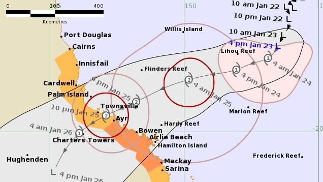
The cyclone is expected to cross the coast late Thursday between Cardwell and Airlie Beach as a Category 2, according to the Bureau of Meteorology’s latest advice, with great concern for the aftermath through much of Queensland.
‘BIG CONCERN’ FOR RAIN AFTERMATH
Senior meteorologist Felim Hanniffy said rainfall totals would hit well over 100mm, including in the South East, with some areas in the Herbert and Lower Burdekin region likely to receive totals of 400mm or higher following Kirrily’s crossing.
“Ranges inland of Mackay will get a lot more,” he said.
“The big concern is where it will go after that.”
Rainfall and flooding is expected to last for at least five days, with modelling suggesting the system could move southwest or southeast.
“The low will be slow moving over the central interior for a couple of days,” Mr Hanniffy said.
“The risk is you can get the system lasting for several days with widespread significant rain and flooding for broad areas.
“A lot of models show the low lingering for four to five days inland, there’s just uncertainty of where it will linger.
“A five-day span is a long time, a lot can change between day one and day five.”
Flooding also has the potential to intensify if the low meets a trough moving up over northern New South Wales and into Queensland.
“Any interactions with other troughs will help draw moisture into the system,” he said.
“There will be a building ridge behind that (NSW trough) which can move the low in a direction, depending on the strength.”
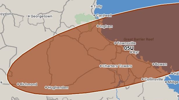
Mr Hanniffy said tropical low 05U had been slow to develop but would be named Kirrily by Wednesday morning.
Tropical Cyclone Kirrily was on Tuesday night positioned to make landfall at Ayr or Townsville.
Modelling showed Kirrily crossing would be a “high-end” Category 2 system but Mr Hanniffy said it still had the possibility to develop into a severe Category 3 system.
“It’s slowly getting organised,” he said.
“Landfall will be later on Thursday, in the late evening or overnight, maybe 10pm-ish.
“It will cross as a high-end Category 2 system but there’s still a risk of it being a Cat 3 if it gets going.
“The crossing focus is Ayr and Townsville.”
Mr Hannify said concerns were focused on the strong gale winds associated with TC Kirrily, which would start impacting coastal areas from Wednesday.
The Bureau will increase its advice to every three hours once an official cyclone warning is released.
Gold Coast Mayor Tom Tate has warned storm-weary citizens they need to prepare for the possibility the city will be smashed by Tropical Cyclone Kirrily on Australia Day.
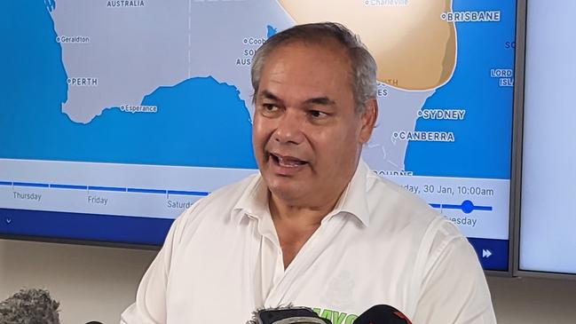
In a sombre briefing at council’s Disaster Management Centre on Tuesday, Mayor Tate said the city was at “response level three” and would be opening sandbag stations amid fears that Kirrily could bring torrential rain and destructive winds to the southeast.
He said council would consider cancelling citizenship ceremonies to ensure the safety of residents, and recommended people made plans for the worst if weather forecasts did not change.“As far as our disaster management centre is concerned we’re now on response level three. It means all hands on deck,” he said.
CYCLONE KIRRILY: WHERE, WHEN, HOW STRONG
In the Bureau’s latest forecast track map and advice, issued at 4.54pm Tuesday, the warning zone extends from Cairns to Ayr (not including Cairns).
The tropical low was at 4pm Tuesday sitting 760km east-northeast of Townsville with wind gusts up to 95kmh. It was moving 8kmh in a south-southwest direction.
Tropical Low O5U is expected to develop into a cyclone late Tuesday or early Wednesday, becoming Tropical Cyclone Kirrily.
Kirrily is expected to intensify and make landfall late on Thursday as a Category 2 before turning and making its way south and out to sea, weakening as it moves across land.
“In the longer term, the system is likely to track inland and south as a deep tropical low bringing heavy to intense rain to parts of central, western and southern Queensland,” the 4.54pm advice said.
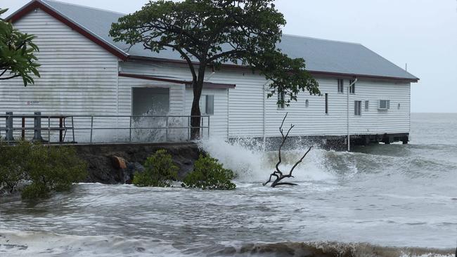
The latest advice said the cyclone would bring gales with damaging wind gusts to 120kmh about the Whitsunday Islands from Wednesday afternoon that may extend to mainland communities between Townsville and St Lawrence overnight Wednesday into Thursday morning.
It also said “gales with damaging wind gusts to 120kmh may extend northward to coastal and island communities between Cairns and Townsville during Thursday”.
“Destructive wind gusts to 155kmh may develop about coastal and island communities between Cardwell and Proserpine including Townsville and the Whitsunday Islands during Thursday,” the Bureau said.
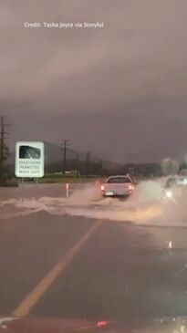
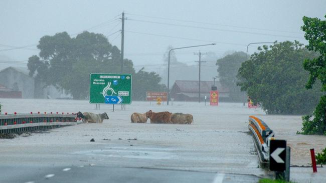
“Heavy rainfall which may lead to flash flooding may develop about coastal areas between Innisfail and St Lawrence from early Thursday before spreading to adjacent inland areas later during Thursday and continuing during Friday.
“Intense rainfall which may lead to dangerous and life threatening flash flooding is possible near and south of the system, most likely with the coastal crossing during Thursday. A flood watch is also current for these areas.
“During Friday, the system is expected to become a deep tropical low and heavy rainfall may develop across central and southern Queensland into the weekend as the system tracks inland and then south.”
HELP ARRIVES AS SYSTEM APPROACHES
Five fire and rescue strike teams have arrived in Townsville in anticipation of Tropical Cyclone Kirrily, with support crews to be deployed to impact zones by 10am Wednesday.
A convoy made up of seven utilities, trucks and a semi trailer carrying swift water rescue gear, extra boats and auxiliary gear for structural damage, pulled into Townsville’s Fire and Rescue Headquarters around 4.30pm Tuesday following a long day of travel from Brisbane.
Gold Coast Station officer Paul Dunn said truckloads of equipment had been hauled up from the south for the cyclone response.
“All the equipment we brought is for the impact of the cyclone and the damage that could come from the strong winds,” he said.
“Possible building collapses and roofs, we’ve got the semi that’s loaded fully equipment for that. Plus all the motorised boats.”
Disaster Assistance Response Teams and strike teams of swift water rescue technicians will be joined by additional support staff Wednesday.
The Bureau’s Morgan Pumpa earlier said the intensity of the cyclone when it crossed the coast was still uncertain, but it’s expected to be severe.
“We could still see some changes with the intensification of this system and its exact direction, as well as its timing as it moves towards the Queensland coast,” she said.
“This would mean the likelihood of very destructive winds – up to 200 kilometres per hour, potentially damaging properties and houses, destroying caravans, significantly damaging crops and knocking down trees and power lines.
“Whether it’s a category two or three … tropical cyclones can bring severe weather and life threatening weather.
“Get prepared now and then stay up to date with the latest information and follow advice.”
State disaster co-ordinator Shane Chelepy confirmed preparations were under way and urged residents to do basic preparations such as ensuring there is enough long-life food in their cupboards for 72 hours and to have mobile phone charging packs where possible.
“The first thing is you must stay in contact with the messaging,” he said.
“Your local council disaster management website is your best place for local information … but also our Get Ready Queensland website will give you some basic tips on what you can do to help emergency services prepare for this event.”

“We know that we have a lot of tourists travelling, we have a long weekend coming up – please reconsider your travel, particularly if you’re camping in these areas, it is not the time to be isolated in our campgrounds,” he said.
As the system approaches and crosses the coast, a storm tide is expected between Townsville and Mackay. Large waves may produce minor flooding along the foreshore. People living in areas likely to be affected by this flooding should take measures to protect their property as much as possible and be prepared to help their neighbours.
On Tuesday, the Bureau’s senior meteorologist Laura Boekel said it was too early to tell which areas would be worst impacted by the potential falls of up to 1000mm.
“We could see impacts within 48 hours,” she said.
PREMIER’S WARNING FOR LONG WEEKEND
Premier Steven Miles has sounded the alarm, saying conditions this weekend could be a repeat of the devastating Far North flooding and the Gold Coast Christmas Day storm.
This morning, he told the ABC the challenge was the “sheer amount of the state” in the firing line from either Cyclone Kirrily itself or the major rain event expected in its aftermath.
“Some of the models predict almost a metre of rain,” he said.
He urged Queenslanders heading out for the Australia Day weekend – including on camping trips – to keep up to date with weather warnings and “make sure they’re not putting themselves in danger”.
He admitted he was expecting the impending events to have a substantial impact on the state’s budget, as the wild summer of weather was already estimated to have cost billions.
“We’re effectively looking at a repeat of those two events (this weekend),” he said.
Mr Miles said “we are going to need to call upon other states and the Australian government if the worst case scenario” happens.
Disaster Recovery Minister Nikki Boyd said there had already been a call to interstate agencies for extra emergency services personnel, specifically swiftwater rescue teams.
HOT WEATHER CONTINUES
The turn in weather will provide some temporary heat relief for residents in the southeast which sweltered through ridiculously high apparent temperatures and stifling humidity levels on Monday.
Brisbane hit a “feels like” temperature of 41.1C by 11.30am – 6C hotter than the actual temperature of 35.4C – while western towns hit above 40C, including Birdsville which reached a staggering apparent temperature of 45.2C.
Humidity levels across the entire southeast measured above 60 per cent, and some exceeded 80 per cent by midday.
It caused thousands of power outages and prompted Queensland Ambulance Service medical director Stephen Rashford to issue a warning to vulnerable residents to remain hydrated and put off any unnecessary outdoor tasks, with the doctor stating medical incidents would undoubtedly increase.
Tuesday was expected to be another hot day about the southern inland and southwest after what was possibly the warmest night on record, as some temperatures remained in the mid 30s.
Birdsville had climbed to 39.6C by 9.20am Tuesday after an overnight minimum of 35.2.C
“The previous highest minimum temperature was on the 31st of December 2019 with 34.6C, so it’s gone up point-six degrees from that previous record to 35.2C,” Ms Pumpa said.
Birdsville will hit 46C on Tuesday, before a minimum of 33C on Wednesday morning and then top at 47C on Wednesday, and 48C on Thursday.
“It does make it very challenging overnight for people to cool down their bodies, especially for animals as well whether it’s your domestic pets,” said Ms Pumpa.
“It’s really important that people continue to take care of themselves for the southern inland and especially the southwest.”
“Even though we’re seeing an easing in the temperatures about the southeast coast, just keep in mind that it has been quite hot.”
Ms Pumpa said the southeast would see some relief in heatwave temperatures for the three days starting today, however it will still be hot and humid.”
“It has eased about the southeast coast but otherwise, people may be still feeling the impact of that heat, and the high dew point temperatures that we have seen about the southeast as well including around Brisbane with those muggy temperatures.”
“We’re just getting out of those severe heatwave conditions and as well with the humidity just stay hydrated, take breaks from the outdoors and from that heat as needed.”
RECORD DEMAND ON ELECTRICITY
The Australian Energy Market Operator has warned it has a lack of reserve electricity generation to meet record high demand in Queensland amid the hot and humid weather.
On Monday night 41,000 were without power, due to the incredible demand, as Energy Minister Mick de Brenni assured Queenslanders the system was “holding up well”.
But Energex spokesman Justin Coomber confirmed the outages were due to a “mixed bag of severe weather”, including the ongoing heatwave and a burst of storm activity.
Mr de Brenni this morning said “there were zero outages related to a lack of supply”.
On Tuesday morning 671 were without power in South East Queensland while 2322 faced outages in regional Queensland.
Cross River Rail workers exposed to soaring temperatures stopped work.
Staff at the Boggo Road site were spotted leaving work and The Courier-Mail was told workers exposed to the heat on the ground of the Gabba site had also gone home.
A spokesman for the Cross River Rail Delivery Authority confirmed on Monday morning workers left job sites in line with heat management policies as temperatures soared above 30C.
But those working in airconditioned cranes and other machinery, as well as those positioned underground where the temperatures were more manageable, continued to work.
It comes after workers walked off the major rail construction project last Friday amid soaring temperatures in Brisbane, with the CFMEU claiming a recent death may have been heat-related.
The Queensland Police Service said a report would be prepared for the coroner relating to the death of the worker, on December 28, and a spokeswoman confirmed the cause of death was yet to be determined.
More Coverage

Originally published as Tropical Cyclone Kirrily expected to form overnight, make landfall Thursday night

Kyrgios arrives for Brisbane International with cheeky dig at famous partner
Nick Kyrgios has offered a cheeky swipe at his ‘greatest of all time’ doubles partner Novak Djokovic as the pair prepare to take the court at the Brisbane International.

International stoush over parking app behind confusing emails to Brisbane motorists
Thousands of Brisbane motorists have become inadvertently tangled in a business stoush between an embattled parking company and an overseas tech giant.