
Queensland weather: 100mm forecast for state’s southeast due to northeast cloudband
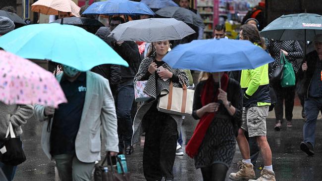
South East Queensland is in for a miserable week as a freak weather pattern develops over Australia, bringing cold temperatures, grey skies and rainfall totals up to 100mm.
QLD News
Don't miss out on the headlines from QLD News. Followed categories will be added to My News.
Parts of Queensland are in for a week of cold temperatures, overcast skies and drenching rain as a freak weather pattern develops over Australia.
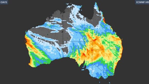
Heavy rain has been falling across parts of the state’s southeast and central regions since Monday, with 43mm near Rolleston in the Central Highlands.
Other notable rainfalls in the last 24 hours include 21mm at Myall Park Road, 20mm in Ipswich, 19mm at Charters Towers and 18mm at Hawkins Creek.
Brisbane received its highest rainfall total since early May, with 9mm.
The Bureau of Meteorology have warned areas such as the Sunshine Coast and Wide Bay region could receive isolated falls of 30-40mm today and 20-30mm in parts of Central Queensland.
Over the next 48 hours, Maroochydore on the Sunshine Coast is forecast to get 50mm in total, with another 50mm could fall from Thursday to Monday next week.
“There’s a bit more rain to come today, it’s definitely the peak, and then we will see it die back tomorrow but showers will persist partially on the coastline,” Harry Clark from BOM said.
A total of 15mm is forecast for Brisbane today with up to 5mm expected every day for the remainder of this until conditions intensify again on Monday, when 10mm is predicted.
The city’s maximum is not expected to climb above 17C today.
Meanwhile, the Gold Coast could get 30mm of rain over the next 48 hours.
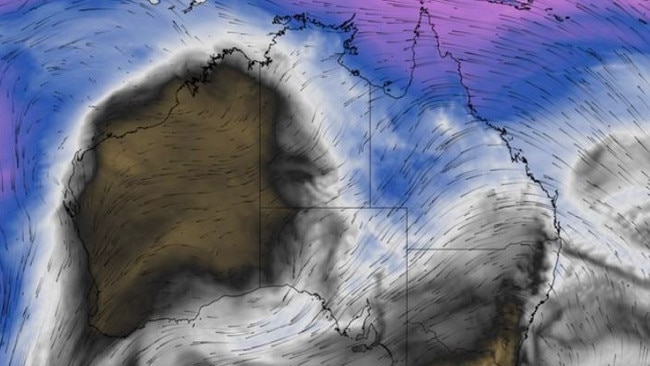
Weatherzone’s Ben Domensino says a rare “northeast cloudband” was causing Coral Sea moisture to clash with a cut-off low directly above Australia.
Mr Domensino said the band of rain-bearing cloud was unusual because it extended over Australia from northeast to southwest, mirroring the more typical northwest cloudbands that develop when Indian Ocean moisture flows from the northwest.
“It’s rare to see a ‘northeast cloudband’ over Australia,” he said.
Mr Domensino said a large high pressure system will deepen to the south of Australia later this week, causing a pool of cold upper-level air to become isolated over the Great Australian Bight.
“The strong high pressure system will also allow a long fetch of east to north-easterly winds to carry moisture-laden air from the Coral Sea towards southern Australia in the second half of this week.
“The combination of this cut-off low over southern Australia and the injection of tropical moisture will cause widespread cloud and rain over multiple Australian states, starting this Thursday and possibly continuing into early next week.”
Mr Domensino says outback communities could also be impacted, with 30-60mm of rain possible.
“While this rain will help fill inland water storages, it may also be heavy enough to impact outback road and rail transport networks,” he said.
“Flood watches and severe weather warnings will be issued later this week and early next week if necessary.”
Mr Clark from the Bureau of Meteorology agreed Queensland could see rainfall intensify into next week.
“Looking long term the next thing to keep an eye out for is another rainband developing in Western Queensland on Friday where we will see that rain come into the weekend and potentially early next week,” he said.
“That is more unusual for the middle of July as Western Queensland has picked up some rain already in the last few days and it’s going to get some more on the weekend.”
Originally published as Queensland weather: 100mm forecast for state’s southeast due to northeast cloudband

Dinner call: Church group’s unusual demands in trial over girl’s death by prayer
Members of a hardline religious group accused of the homicide of a little girl have issued a series of unusual demands ahead of their Supreme Court trial.
Man charged with drink driving after car smashes through fence
A Bracken Ridge family is repairing its driveway after a car rammed through their front fence overnight, with the driver charged with mid-range drink driving.