
Storms, floods, humidity: Qld to be smashed by week of wild weather
A fresh cyclone threat is on the cards for Queensland as another tropical low is expected to develop in the Coral Sea this week. It comes as the state’s south has been hit with heavy rain.
QLD News
Don't miss out on the headlines from QLD News. Followed categories will be added to My News.
A fresh cyclone threat is on the cards for Queensland, with another tropical low expected to develop in the Coral Sea.
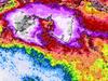
The low will form approximately 700-800km off the Queensland coast by the end of the week.
While the low will initially move east, away from the Queensland coast, according to the Bureau of Meteorology it will likely strengthen on the weekend and make a u-turn back towards the coastline.
The south-west direction change will increase the chance of a cyclone developing to 25 per cent come Monday next week.
“We will then see [next] Monday that the environment becomes a bit more favourable and once that monsoon starts to weaken it won’t be getting that push out to the Coral Sea,”
The Bureau’s Shane Kennedy said.
“That is what might allow it to drift back towards the Queensland coast.
At this stage there are a range of scenarios that the system could take, and Mr Kennedy said the Bureau could not pinpoint exactly which direction it would move in.
“It’s definitely a watch point over this week and next,” he said.
The monsoon system for the eastern parts of Far North Queensland will see a reprieve from the heavy rainfall as it starts to weaken.
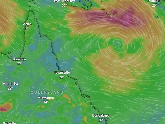
However, with the low bringing heavy rainfall to the Northern Territory, Western Queensland in parts of Cape York and the Gulf of Carpentaria could continue to see those significant totals.
“It’s a bit of a tail of two halves for the monsoon trough with Western Queensland picking up in the next few days, while the Eastern side is peaking about now and on a weakening trend later this week,” Mr Kennedy said.
The Far-north Tropical Coast can expect another peak in rainfall on Monday night with 100-200mm falls expected through to Tuesday morning.
“It’s still quite wet for the rest of the week,” Mr Kennedy said.
“We will see what happens at the end of this week and next with the 05U low, how deep it gets and if it moves south or south-west back towards the Queensland coastline.”
The cyclone warning comes as the state’s south was hit with more heavy rain, with Goolman recording 45mm in the 30 min to 1.59pm.
The BoM has issued a severe thunderstorm warning for people in parts of North Tropical Coast and Tablelands and Northern Goldfields and Upper Flinders forecast districts.
Isued at 5.57pm, the warning for heavy rainfall said “a very moist unstable environment is leading to heavy rainfall with storms about the North Tropical Coast inland”.
“Severe thunderstorms are likely to produce heavy rainfall that may lead to flash flooding in the warning area over the next several hours. Locations which may be affected include Atherton, Millaa Millaa, Ravenshoe and Mount Garnet,” it said.
A previous severe thunderstorm warning for damaging winds and heavy rainfall for people in parts of Maranoa and Warrego and forecast districts, issued early Monday afternoon, has since been cancelled.
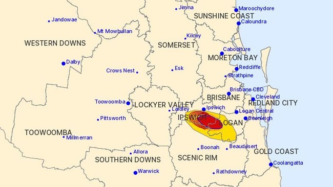
A previous severe thunderstorm warning, which BoM issued at 2.09pm for people in parts of Ipswich, Logan and Scenic Rim council areas, has been cancelled.
The warning had been issued after “a severe thunderstorm likely to produce heavy rainfall that may lead to flash flooding was detected near Bundamba Lagoon”.
The slow-moving storm had been forecast to impact the area south of Amberley by 2.30pm and Peak Crossing and Amberley by 3pm.
The Courier-Mail earlier reported southeast Queensland was set for a week of rain and thunderstorms as humidity across the region soars and wild winds continue to lash the coast.
Bureau of Meteorology senior metrologist Miriam Bradbury said it was keeping a close eye on a set of storms that will begin to roll in on Monday afternoon across the Sunshine Coast, Brisbane and Gold Coast regions.
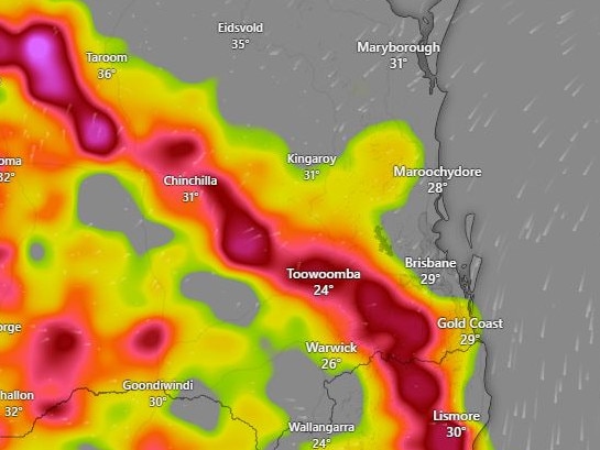
“We are expecting scattered showers moving through from Monday and until the later part of the week as well as the weekend,” Ms Bradbury said.
“While most of the storms are expected to be fairly patchy in nature there is a chance of up to 20 to 25mm if they become more concentrated.
“Most of the thunderstorms will hit around the mid afternoon to later evening time and it definitely worth keeping an eye on the radar.”
Severe thunderstorm warnings are possible to the west.
“Around the coast and in the cities this week we should see some tops of about 30C while inland it will hit that little bit hotter,” Ms Bradbury said.
“We should expect to see some severe thunderstorm warning out in the west, a little bit around the Darling Downs region but more so in that further inland region.
“The usually lightning, high winds and some rumbles are expected as well as some reasonable rainfall totals, especially in the west.”
Severe weather continues to plague the state, with those in southeast areas inundated with rain along with monsoon affected residents in the far north.
The hardest hit areas remain in the north, where some flood affected areas will be hit with up to 30mm of rain each day this week.
Flood watch remains in place for The Cape York Peninsula and parts of The Gulf of Carpentaria as flood warnings are enacted for the Paroo, Tully, Murray, Barcoo, Bulloo and Diamantia Rivers.
A major flood warning has been enacted for the Paroo River around Eulo, as the rain pushes river levels to rise “significantly.
“The Paroo River at Eulo is currently at 3.80 metres and expected to be rising slowly, with moderate flooding (moderate flood level 3.00 metres),” the Bureau warned.
“The Paroo River at Eulo may peak around the major flood level (4.00 metres) overnight Sunday into Monday.”
This week’s thunderstorms in the southeast are being powered by high humidity and an east-south-easterly breeze swinging in from offshore, which is expected to last well into next week according to BOM.
“The forecast will be fairly similar for the rest of the week and into next week so it is worth keeping an eye on the forecast if you are heading out because of these thunderstorms,” Ms Bradbury said.
More Coverage
Originally published as Storms, floods, humidity: Qld to be smashed by week of wild weather
Join the conversation

‘Keep your kids at home’: Bombshell call to parents ahead of teacher strike
The powerful Queensland teachers union has urged parents to “make alternative arrangements” as thousands of staff prepare to walk off the job next week for the first time in 16 years.
Read more

Driver trapped, lanes closed after motorway crash
A woman has been injured and the peak-hour commute thrown into chaos following a two-vehicle crash on the Ipswich Motorway.
Read more