
NT remains safe as Tropical Cyclone ‘Ilsa’ develops in Western Australia
An Easter weekend storm is set to become a cyclone just west of the NT. Here’s how it will impact the Top End.
Northern Territory
Don't miss out on the headlines from Northern Territory. Followed categories will be added to My News.
The weekend’s soggy weather is set to ease up as a tropical low moves further west into Western Australia.
The low is expected to develop into a cyclone on Monday afternoon.
Bureau of Meteorology senior meteorologist Billy Lynch said the system – to be named Tropical Cyclone “Ilsa” – would not impact the NT.
“It will have less and less of an impact from this point on,” he said.
Mr Lynch said the Top End would see its showery conditions continue on Monday and Tuesday, with little “breaks of sunshine” in-between.
“It’s back to normal wet season weather,” he said.
Tropical low to become a cyclone later today with gales and heavy rainfall possibly developing along the Kimberley coastal fringe. Cyclone Warning cancelled for Kalumburu to Kuri Bay this morning https://t.co/B1MVXBHUfhpic.twitter.com/s5QPoVKvnz
— Bureau of Meteorology, Western Australia (@BOM_WA) April 9, 2023
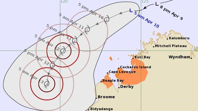
The Bureau of Meteorology at 6.51am Monday said the tropical low was developing at a slow rate, would intensify further in the next two days as it moves southwest along the Kimberley coast.
“There is a significant risk that this system will intensify into a severe tropical cyclone during Wednesday,” the Bureau said.
“It is expected the track will turn to the south during the middle of the week and a severe impact is likely along the coast between Port Hedland and Broome, during Thursday or Friday.”
The impacted region in Western Australia stretches from Kuri Bay to Beagle Bay, excluding Derby.
It is expected wind gusts of up to 90km/h and heavy rainfall will develop in the area, bringing abnormally high tides between Kalumburu and Kuri Bay on Monday and Tuesday.
“In some locations the tide may be close to the highest astronomical tide of the year,” the Bureau said.
Sunday, 12.24pm: Storms to continue as Cyclone ‘Ilsa’ intensifies
The Top End will continue to experience rainy and cloudy conditions for the rest of the long weekend as Tropical Cyclone Ilsa approaches the Kimberley region.
Bureau of Meteorology senior meteorologist Billy Lynch said Tropical Cyclone Ilsa would not have an impact on the Northern Territory, with the cyclone moving towards Western Australia.
“It’s moving away from the Northern Territory, it’s currently about 300km to the west of Darwin out in the Timor Sea, it will continue to move away from us.
“For the rest of today and tomorrow (in the Top End), it’s generally going to be cloudy and we’ll see scattered showers and thunderstorms coming through, with temperatures down as well.”
Mr Lynch said in the past 24 hours Croker Island experienced 141mm of rain, with 20mm to 30mm recorded in most other areas.
“For the rest of today tomorrow most of the Top End can probably expect 10mm to 30mm including Darwin, but it’s mostly around the coast and Tiwi Islands where we could see those high rainfall totals of maybe 80mm to 100mm.”
He said cloudy and rainy conditions would ease on Tuesday or Wednesday, although showers and thunderstorms would still occur less frequently.
But marine wind warnings have been issued for the Beagle Bonaparte and North Tiwi Coasts on Saturday and Sunday.
Stay up to date with the latest forecasts and warning this Easter long weekend via our website https://t.co/UPVY9cG3j0, BOM weather app and social media. pic.twitter.com/Z1RtNBuZRX
— Bureau of Meteorology, Northern Territory (@BOM_NT) April 6, 2023
It comes after warnings a tropical low was expected to move west into the Timor Sea on Saturday, strengthening to a moderate chance of a tropical cyclone off the northwest Kimberley coast Sunday and Monday.
The Tropical Cyclone Outlook currently has the likelihood of a tropical cyclone forming in the Northern region at High, or a more than 50 per cent chance, on Sunday and Monday.
The system will continue moving to the southwest early next week to sit offshore from the Pilbara coast during Tuesday or Wednesday.
Heavy rainfall and destructive winds nearby are expected from mid-next week, with active thunderstorms for the northern Kimberley from Sunday.
The Bureau’s senior meteorologist Sally Cutter said the biggest impact would be felt in Western Australia.
“We’re not expecting any impact in the Northern Territory other than perhaps some extra storm activity along the north coast,” she said.
“It’s a slow moving system and it’s gradually building, so if it does become a cyclone that will be Sunday night, Monday morning.”
While the possible cyclone path is not headed towards Darwin, the city will experience possible severe thunderstorms Friday and Saturday.
Thunderstorms are possible over the rest of the weekend and through the week.
Showers are also likely, bringing up to 20mm rain on Sunday and Monday.
“The showers and storms will be mainly along the northern parts of the Top End,” Ms Cutter said.
“You won’t see much storm activity south of Renner Springs.”
More Coverage


Originally published as NT remains safe as Tropical Cyclone ‘Ilsa’ develops in Western Australia
Join the conversation

‘Fundamental freedoms’: Controversial discrimination laws introduced
The NT's anti-discrimination watchdog warns new reforms will erode Territorians rights, while the CLP says it is 'restoring balance' between protections and free speech.
Read more

30+ photos: Racing fans enjoy Corporate Cup day
As racegoers and those in the action turn their eyes toward what will be a huge weekend of racing, the Darwin Cup Carnival celebrated the Dabble Corporate Cup. Check out all the photos.
Read more