
Mapped: our first taste of hot, dry season
Warm and dry conditions are set to dominate most of the country, with daily maximums spiking 10 degrees above average in some areas. Find out what’s in store.


Weather
Don't miss out on the headlines from Weather. Followed categories will be added to My News.
Australia: beautiful one day, perfect the next.
And the next. And the next.
A week of warm and dry weather across most of the country over the coming week will give Aussies a taste of the conditions expected to dominate this spring and summer.
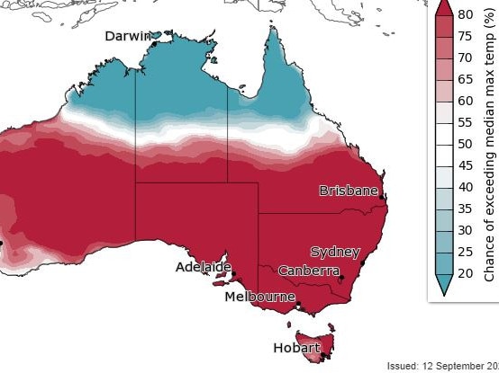
Most capital cities are expected to bask in warm and dry conditions until at least Tuesday, with daily maximums spiking 10 degrees above the historical monthly average in Sydney, Melbourne, Adelaide and Canberra.
It’s all thanks to an extremely large and slow-moving high pressure system sitting on top of the country right now, said senior meteorologist Dean Narramore from the Bureau of Meteorology.
“It’s almost the size of the country as a whole, and it’s taking almost a week to move to the Tasman Sea early next week,” he said.
“As it does it’s tending winds more northerly and then north westerly, which is dragging all that warmth which normally sits across northern and central Australia down into southeastern and eastern parts of the country.”
The system is so dominant that a cold front hitting Perth today will be forced down and eventually slide under Tasmania, missing everyone in the east and southeast entirely.
While daily maximums are not expected to hit new temperature records, the longevity of the warm weather is “definitely unusual” for this time of year, Mr Narramore said.
“Normally at this time of year you get one or two days before the next weather system moves in. Mainly it’s in autumn, or the end of summer, when we get these big runs of nice weather.”
The arrival of a prolonged spell of warm weather so soon in spring is also somewhat unusual, he said.
On Wednesday the Bureau again stopped short of declaring an El Nino event, despite international meteorological organisations forecasting one for the second half of 2023 as far back as July.
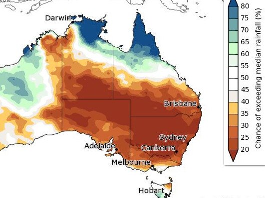
The Bureau’s latest Climate Driver Update revealed a positive Indian Ocean Dipole was now “very likely to emerge”, and this condition “typically decreases spring rainfall for central and southeast Australia and can increase the drying influence of El Nino”.
Mr Narramore said whether an El Nino was declared by the agency or not, the outlook was not going to change.
“We’re still looking at a warmer and drier outlook in the coming weeks and months,” he said.
Australia’s last El Nino was in the summer of 2015/16, while our last three summers have been dominated by the cooler, wetter La Nina climatic phenomenon.
El Nino events in Australia are associated with the increased likelihood of heatwaves, droughts, bushfire conditions and bleaching on coral reefs.
The Bureau’s Climate Driver Update stated that sea surface temperatures in the central and eastern Pacific currently exceed El Nino thresholds, and indications were they would stay that way until early 2024.
“If the atmosphere responds to this warming, an El Nino event would be expected to develop,” the Climate Driver Update stated.
HEATING UP: THE WEEK AHEAD
Maximum forecast temperatures for the period September 13-19.
Source: Bureau of Meteorology
SYDNEY
THURS 23°
FRI 25°
SAT 30°
SUN 28°
MON 27°
TUES 30°
Sydney September historical average: 20.1°
Sydney September highest on record: 34.6°
MELBOURNE

THURS 25°
FRI 25°
SAT 25°
SUN 22°
MON 25°
TUES 27°
Melbourne September historical average: 17.3°
Melbourne September highest on record: 31.4°
BRISBANE
THURS 24°
FRI 25°
SAT 26°
SUN 27°
MON 27°
TUES 27°
Brisbane September historical average: 25.6°
Brisbane September highest on record: 37.0°
ADELAIDE
THURS 28°
FRI 22°
SAT 24°
SUN 26°
MON 29°
TUES 25°
Adelaide September historical average: 18.4°
Adelaide September highest on record: 35.1°
HOBART
THURS 23°
FRI 20°
SAT 18°
SUN 16°
MON 19°
TUES 21°
Hobart September historical average: 15.2°
Hobart September highest on record: 31.0°
DARWIN
FRI 34°
SAT 34°
SUN 33°
MON 33°
TUES 33°
Darwin September historical average: 32.7°
Darwin September highest on record: 38.0°
CANBERRA
THURS 25°
FRI 24°
SAT 25°
SUN 25°
MON 26°
TUES 27°
Canberra September historical average: 17.6°
Canberra September highest on record: 30.2°
PERTH
THURS 20°
FRI 22°
SAT 22°
SUN 20°
MON 19°
TUES 20°
Perth September historical average: 20.5°
Perth September highest on record: 34.2°
Originally published as Mapped: our first taste of hot, dry season
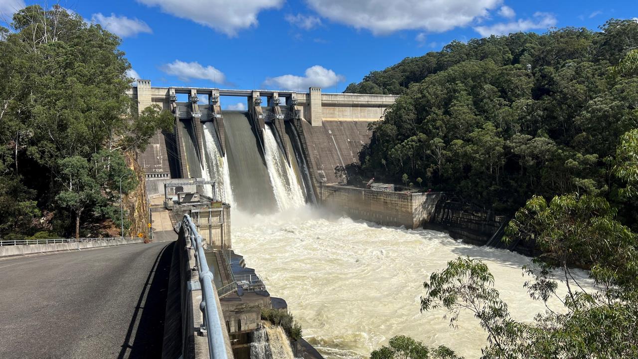
Warning to residents as major dam spills
Warragamba Dam has spilled in Sydney as the flood clean up got underway in other parts of the state.
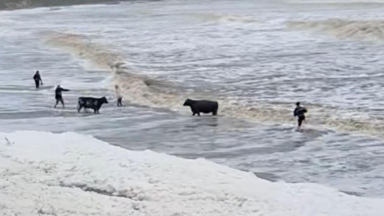
Flood chaos as cows wash ashore on beach
Hundreds of rescues have occurred across one state as about 16,000 are set to be isolated due to rising floodwaters and 150mm deluges dropping over six hours.