
Google Earth map shows true impact of bushfires across NSW
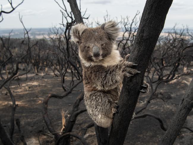
Satellite images of the areas of NSW annihilated by a bush inferno confirm our worst fears. The maps show more than five million hectares of the state has been razed, including one quarter of the koala habitat.

NSW
Don't miss out on the headlines from NSW. Followed categories will be added to My News.
A satellite map has for the first time unveiled the true impact of the devastating bushfires on NSW’s wildlife, while confirming fears a quarter of koala habitat is gone.
But the Google Earth vegetation map also reveals pockets of green where wildlife may have taken refuge during the fires, pointing the way for scientists and wildlife carers to help animals and plants recover.

More than five million hectares — 6.4 per cent of NSW — has so far been ravaged this bushfire season in blazes the state government now admits were “unprecedented” in their extent and intensity.
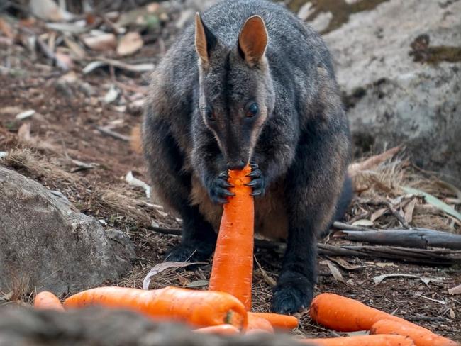
The exact toll on the state’s flora and fauna is emerging, with the habitats of 60 threatened species affected by fire.
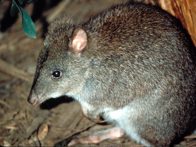
For six threatened species — the long-footed potoroo, the philoria pughi frog, Hastings River mouse, brush-tailed rock wallaby, parma wallaby and the Eurobodalla greater glider population — much of their habitat has been affected.
MORE FROM LINDA SILMALIS:
‘Weeding my garden gave me cancer’
Population of NSW set to reach 10 million by 2036
Flora has also been devastated, with a staggering 95 per cent of forests containing threatened plant species affected, while fire ripped through more than 80 per cent of the declared Blue Mountains World Heritage Area.
On the NSW east cost, more than 24 per cent of known koala habitat has been lost.
A joint initiative between the NSW Department of Planning Infrastructure and Environment Remote Sensing and Landscape Science team and the University of NSW, the Google Earth Engine Burnt Area Map (GEEBAM) will allow scientists and ecologists to determine exactly what fauna and flora has been affected by fire while aiding recovery efforts.
Using the NSW Rural Fires Service’s “Fires Near Me” app, the Google maps detail the level of impact each fire had on vegetation by identifying how badly an area’s tree canopy has been affected, including whether it has been destroyed. Destroyed tree canopies are evidence of the most intense fires.
The maps, which will be updated every two weeks, confirm the most devastating fires occurred on the state’s north coast, especially west of Coffs Harbour and north of Grafton, where little tree canopy remains within the firegrounds.
The next most destructive blazes occurred south of Goulburn, where the Currowan fire wiped out a large swath of forest.
To Sydney’s north, the Gospers Mountain and Grose Valley fires destroyed numerous bush areas that featured tree canopies.
A department assessment revealed 5.1 million hectares had been burnt as at January 10, including 34 per cent — 2.5 million hectares — of the entire national park estate.
The most affected vegetation was heathlands, with more than half affected by fire, followed by wet sclerophyll forests with more than 40 per cent burnt.
And in a sign of the intensity of the fires, 35 per cent of rainforest was burnt — although this was less than first feared.
Within the state’s national park system, fire affected 99 per cent of 55 reserves, and more than 75 per cent of another 70.
Of the 300 fauna species listed as “threatened” under the NSW Biodiversity Conservation Act 2016, the habitat of 60 were affected by these fires.
But in some good news, the maps reveal pockets of green within the firegrounds where tree canopies have survived the onslaught of flames, indicating areas that became possible refuges for wildlife.
The assessment report said the Google Earth imagery would enable the department to work out where the fire had “skipped over” a fireground, leaving it little affected, compared with areas where the tree canopy had been affected or completely destroyed.
It said the department was developing more detailed maps for each fireground.
“The intensity of the fires has varied widely,” the department report said.

Environment Minister Matt Kean said the maps have been made available on the SEED Environmental Data Portal to allow other scientists and experts to understand what has occurred and contribute to the recovery effort. As well as food drops, water, pest control and population surveys, the state government was working on a broader wildlife recovery plan to protect threatened species and unburnt areas of habitat.
“We are working closely with the federal and Victorian governments as well as experts in developing this plan, which will need to evolve as our understanding of the impact of the fires develops,” he said.
The map used imagery from July to August 2019 to determine the extent of green vegetation before the fire season commenced, with the first map documenting burnt areas up to January 6.
It is regarded as the most comprehensive information available to enable an understanding of the impact of fires on biodiversity.

The map will feed in to work under way at a national level, with a federal government panel of ecologists, conservation biologists and other experts determining locations of newly endangered or vulnerable flora and fauna.
Work on a national map is well under way, with $25 million set aside to help fund recovery efforts such as long-term habitat restoration.
Preliminary data from the expert panel confirms about 80 per cent of known locations of 50 threatened species in southern and eastern Australia have been impacted by fire.
Originally published as Google Earth map shows true impact of bushfires across NSW
Join the conversation
‘Dark days’: Mum’s heartbreaking ten-year ordeal before miracle bub
After a decade of IVF attempts, three crushing losses and spending a sizeable house deposit, one woman had a miracle bub through a low-cost model. But she says more needs to be done to help women in regional NSW.
Read more

‘Shocking failure’: Abbott slams PM over terror intelligence breakdown
Ex-PM Tony Abbott and security experts have blasted an “alarming breakdown” in communication between the state and federal government as Sydney narrowly dodged a ‘mass casualty event’ over a foiled anti-Semitic terror plot.
Read more