
Chances increase of a cyclone forming in Gulf of Carpentaria
Forecasters have said there is now an increased chance that a cyclone bringing as much as 200mm of rain could strike Australia.

It’s looking more possible that a tropical low in Australia’s north could strengthen into a cyclone on Thursday or Friday, forecasters have warned.
It comes after a freak storm on Tuesday left half a million homes and businesses without power in Australia’s south.
As of Thursday morning, tens of thousands are still in the dark.
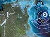
The Bureau of Meteorology (BOM) stated early on Thursday that tropical low 07U was in the Gulf of Carpentaria heading south towards eastern parts of the Northern Territory near the Queensland border.
It is estimated to be 160 km northeast of Borroloola and 295 km northwest of Mornington Island.

Increased chance
The Bureau has said there is “moderate chance” that it could strengthen to a cyclone overnight on Thursday or during the day on Friday.
That’s an increase from earlier forecasts which had suggested the risk of 07U becoming a cyclone was relatively low.
The system was “likely to bring strong winds and heavy rainfall to the southern Gulf of Carpentaria later Thursday and during Friday,” the BOM said.
Winds near the centre of the low are currently 45km/h with wind gusts to 85km/h. But as it nears land these winds could ramp up to around 100km/h.
On Friday, the system is expected to cross land. It will then probably head in a roughly south west direction passing north of Tennant Creek and into Western Australia.

“Damaging wind gusts could extend west to Port Roper in the Northern Territory and east to Burketown in Queensland during Friday depending on the movement of 07U,” said the BOM.
Heavy rainfall could also come down on the Gulf’s southern coast on Thursday and into Friday with locally intense rainfall.
Rainfall totals of 50-100mm over Thursday and Friday will be very normal in the affected areas with up to 200mm in some isolated pockets.
Residents of Borroloola and other communities are advised to have a plan in place for when the low approaches and keep up to date with BOM warnings.


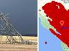
In Victoria, more than half a million properties were left in darkness on Tuesday after violent storms smashed Melbourne and surrounding areas.
The storm caused Victoria’s largest power station, Long Yang A, a coal plant, to stop producing electricity when transmission towers linked to it collapsed.
On Wednesday evening, 127,000 homes and business were still without power in the state.
On Thursday morning, CitiPower and Powercor stated around 500 customers in Victoria’s east remained without power. Tens of thousands of customers in the state’s east were still without power according to AusNet.
Originally published as Chances increase of a cyclone forming in Gulf of Carpentaria
