
Tropical Cyclone Alfred: Everything Gold Coasters need to know about impact of wet weather
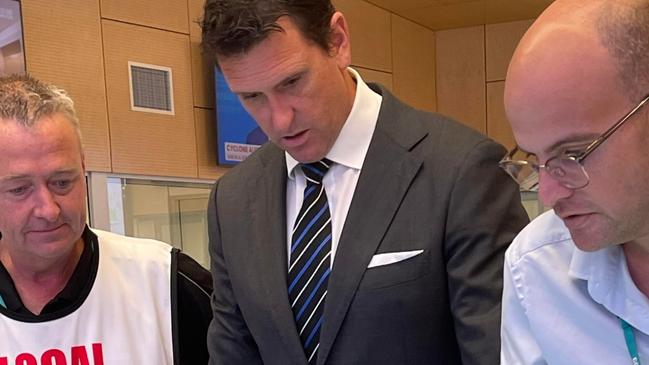
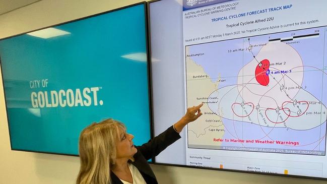
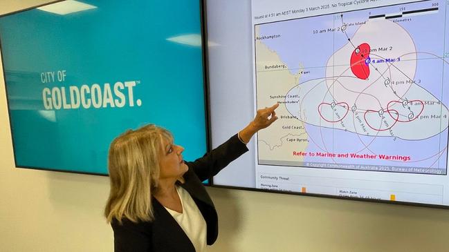
Mayor Tom Tate has outlined an ambitious timeline for fixing the Gold Coast’s beaches after enormous damage done by Ex-Tropical Cyclone Alfred. LATEST INFORMATION
Weather
Don't miss out on the headlines from Weather. Followed categories will be added to My News.
The Gold Coast’s badly-damaged beaches can be repaired in time for the April holiday season, Mayor Tom Tate has said.
The City is yet to put price tag on the beach fix after Ex-Tropical Cyclone Alfred, with the Mayor and CEO Tim Baker planning a helicopter flight later on Monday to survey the damage. However the cost is likely to be hundreds of millions of dollars.
“With the helicopter I want to check out the beach, the Greenheart and other areas, I’ll gauge it say, in comparison to (Cyclone) Oswald,” Mr Tate said.
“I’ve already got in place some of the solutions to fix our beaches very quickly. I give this undertaking – the beach will be recovered and ready for the April school holidays.
“It’s wide ranging. We’ve got our own equipment – we are yet to finalise dredging. If you can remember back in 2017, we brought in the dredge that we nicknamed Rainbowing, so you actually pump the sand outlying off the beach straight onto our beach and sweep it right up.
“First we will do our most popular beach and then we will go up and down to bring our beach back.”
City administrators believe some beaches can be repaired earlier than April.
“We will start to fix the access to our beaches from tomorrow,” Mr Tate said.
“Out in the Broadwater there are 20 sunken boats. So authorities are aware of these, my advice is to stay away from the waterways, there is no need to undertake recreational boating activities for now,” he said.
Asked if he had spoken to Premier David Crisafulli or Prime Minister Anthony Albanese about beach repair funding, Mr Tate replied: “We look at the rules on funding and that. But my instruction to the CEO is to get out there, let’s plan and fix the problem, how that funding comes and who pays for what we will sort that out later.”
Mr Tate said the city had 64,000 properties without power but he praised Energex in restoring electricity and welcomed the patience of customers.
“Water and sewerage is holding up. The quality of water is good,” he said.
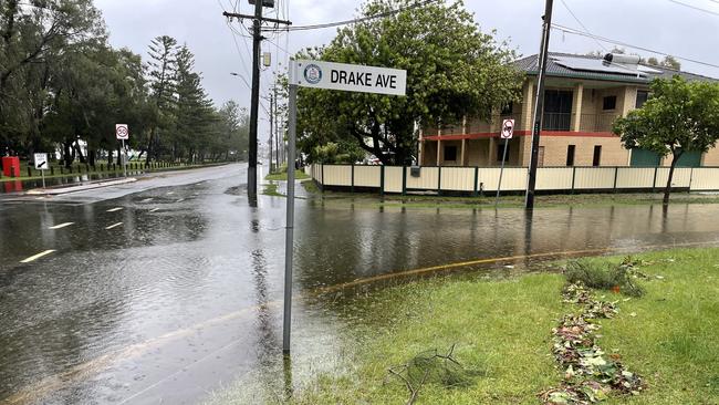
The City at 2pm on Monday was maintaining its red flood alert for some northern suburbs, which was for residents to stay in place.
But it had downgraded warnings for the south around Currumbin with residents asked to monitor flooding.
The general flood warnings for across the city have been downgraded. Residents are asked to check the City of Gold Coast Dashboard.
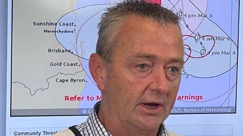
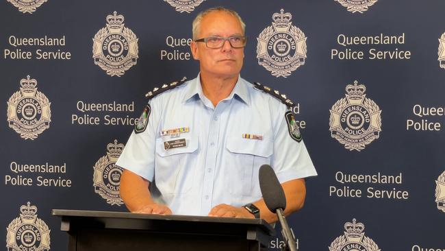
Acting chief superintendent Peter Miles said police from north Queensland were heading to the Gold Coast and Logan to assist with extra patrols.
“They were briefed this morning. They will hit the ground running. It boosts our numbers and sends a clear message we want to keep the community safe at all hours,” he said.
EARLIER ON MONDAY
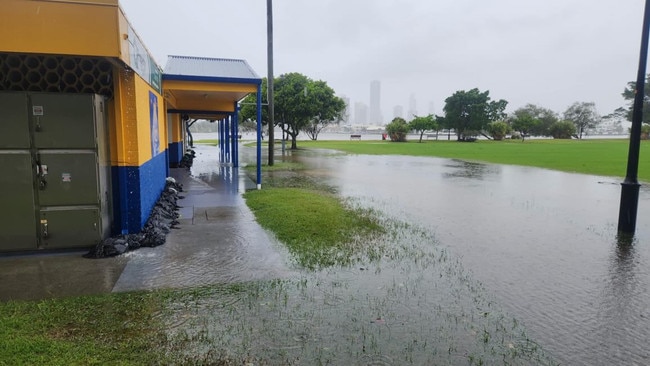
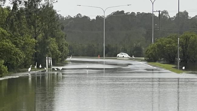
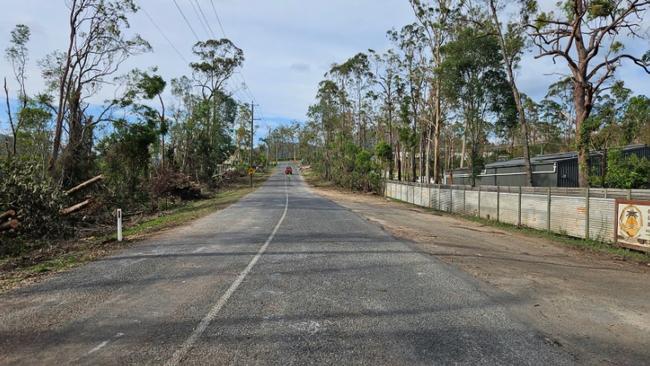
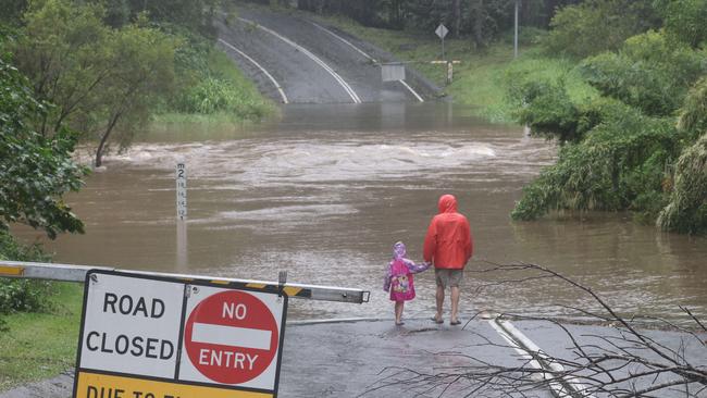
Swift-water rescues, record rain in some suburbs and more than 100 roads flooded has been the farewell delivered for the Gold Coast by Ex-Tropical Cyclone Alfred.
Mayor Tom Tate, in an exclusive update to the Bulletin, said three swift water rescues were conducted by Queensland Fire and Rescue overnight. Another was occurring at Parkwood just before 10am on Monday.
The final messaging from the City in multiple alerts after unrelenting final burst of rain overnight switched from the beaches and staying inside to preventing a flooding tragedy.
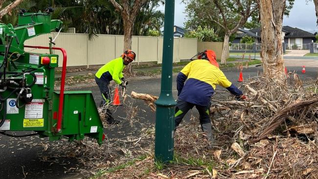
A full “restoration plan” — part of what council is calling Operation Clean-up 2.0 after last Boxing Day Tornado — is expected to be released on Monday.
“The Gold Coast has experienced a significant amount of rainfall overnight. If it’s flooded, forget it. Please don’t put yourself and others at risk,” the Mayor said.
In the last 24 hours, rainfall levels reached 316mm at Oxenford, 368mm at Wongawallan and 273mm at Springbrook. Most northern suburbs recorded in excess of 100mm, according to the Bureau of Meteorology.
“Heavy rainfall is forecast to ease on Monday,” Mr Tate said.
Only light showers are being predicted for the rest of the week.
City of Gold Coast sent out four warnings since early Sunday.
Flood emergency warnings were sent out for Luscombe, Yatala, Stapleton and Alberton in the City’s far north after residents were alerted from 1am.
“The top end has copped a thumping,” an Alberton resident said, trying to negotiate roads to get to work. The two roads into Jacobs Well were flooded.
Mr Tate said some roads would remain closed despite the water receding later in the day. At least 109 are closed for various reasons with 95 intersections lacking power.
An earlier warning overnight had been issued for Carrara, Benowa, Emerald Lakes, Clear Island Waters, Mermaid Beach and Merrimac.
Currumbin, Tallebudgera and Elanora were the other hot spots for flooding with water lapping around some club headquarters.
A warning was continuing through Monday morning for Arundel, Biggera Waters and Labrador, due to rising levels in the problematic Biggera Dam.
Sections of Napper Road at Parkwood, which is near the dam, had become a brown river including entry to the Titans training area.
Key takeaways from the latest update include:
* more than 71,000 properties remain without power. This is down from 84,000 from Sunday afternoon. Energex crews will attend to those in the next few days.
* the City has completed 545 work orders since Wednesday with 845 outstanding. More than 200 staff were on the ground on Monday.
About 604 jobs were underway, with 1100 to be processed.
* State Emergency Services (SES) completing 2400 jobs. Their volunteers are scoping flooded areas.
* at least 50 Australian Defence Force staff began helping with blocked roads. Additional emergency workers are on the way.
* normal bin services began on Monday with residents asked to put food and perishables in their general waste bin. Large skips are being provided.
* no water quality issues have occurred but residents are being asked to conserve water.
Mr Tate asked residents to drive to conditions, given the flooding and traffic lights being out on so many intersections.
“Before leaving the house, we encourage all residents to check the City’s dashboard for an up to date list of road closures,” he said.

EARLIER
Mayor Tom Tate has returned to the Gold Coast to start “Operation Clean-Up 2.0” as the aftermath of ex-tropical cyclone Alfred continues to lash the city.
A monster clean-up, expected to cost at least $1.8bn, will kick off on Monday as the city grapples with the damage caused by the now-tropical low.
The reopening of Gold Coast Airport and major shopping centres began on Sunday but other major services are still days away from resuming, with schools and the Tugun Health Centre to remain closed on Monday and bus and tram services still suspended.
The Mayor arrived back in the city via Melbourne just before midday Sunday – he had been trying to get flights back after a private trip to watch the NRL season kick-off in Vegas – as the council sent out flash flooding alerts for Currumbin Creek.
Mr Tate, when asked when the weather system would clear, replied: “Well mother nature is very unpredictable”.
“Where Alfred goes, only Alfred knows. I want to make sure Alfred is at a storm level,” he said.
“My own prediction is that it will keep going that way (out west), I don’t think there will be a U-turn.”
Mr Tate thanked Deputy Mayor Donna Gates for her “sterling effort” across the last six days leading a successful team campaign.
“Boy, as far as I’m concerned, when you get someone off the bench to do the job, they are even better than the person in the starting line-up,” he said.
The Mayor, in key updates on Sunday, said:
* 57 roads are closed due to flooding or blocked by trees or powerlines.
* 103,000 properties remain without power, down from 140,000 on Saturday.
* Evacuation centres have become relief centres for charging of medical equipment and essential communication devices.
* 503 work orders have been completed since Wednesday with 1400 outstanding.
* Around 160 sewerage pump stations are out of order but being addressed, with generators at the prime ones.
* 85 broken water mains but no issue concerning drinking water.
* More than 800 trees are down, and 43 per cent of traffic lights not working.
* 2010 SES jobs currently locked in and defence personnel are knocking on doors to check on people.
* Significant communication problems continue with issues involving Telstra and Optus towers.
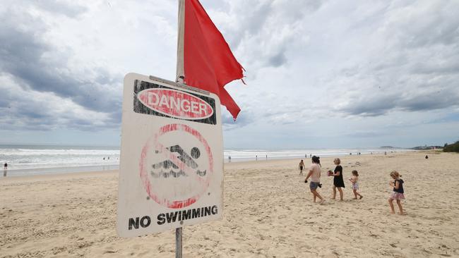
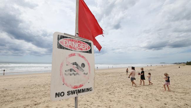
* Beaches are closed.
* Flooding was minor and localised to Currumbin and Tallebudgera creeks.
Prime Minister Anthony Albanese and federal Treasurer Jim Chalmers visited the city’s disaster management centre late on Sunday afternoon.
The pair met with Mr Tate and council CEO Tim Baker but did not take questions from media.
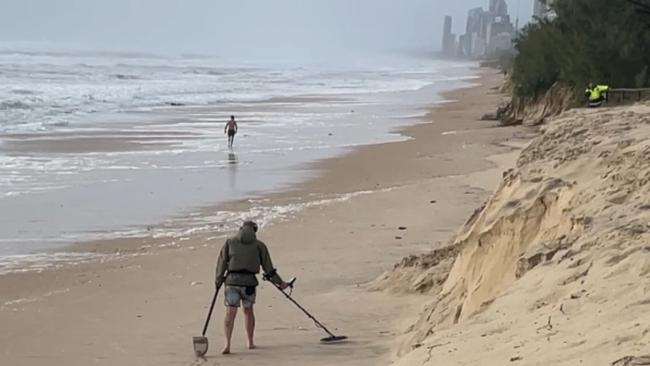
Mr Tate said urged the public to be careful on the heavily eroded beaches.
“The rain should subside by morning, so the temptation for people to go for the foreshore of our beaches – please stay away from that, just while we try to fix things up,” Mr Tate said.
At 1pm, the disaster management team headed by co-ordinator Mark Ryan along with Council Mr Baker met to kick in plans for what insiders are calling “Operation Clean-up 2.0”
They have been planning the operation for a week, skilled up on what was learned from the original operation clean-up following the shock Christmas night storm in December 2023.
A Council source said: “It’s Operation Clean-Up 2.0. We had 1.0 with the Christmas storms. It will be the same process with massive resources thrown at it from the ground.
“We will see skip bins out there. Council staffers will be out there cleaning up parks. We will be having staff redeployed to that.”
The Christmas storm which ripped through the city’s north in 2023 was as strong as a Category 2 cyclone causing $1.8bn in damage.
Council is yet to put a price tag on the cost of Alfred, but is it likely to be as much.
“You are talking hundreds of millions of dollars,” a Council source said, referring to damaged public infrastructure.
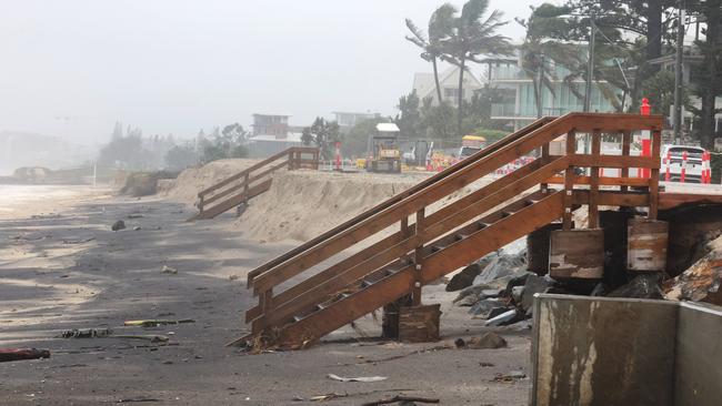
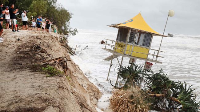
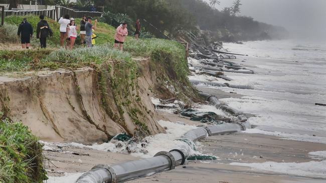
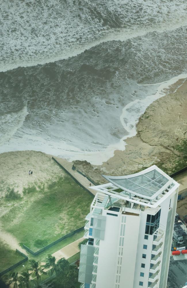
A major focus on the clean-up will be the Gold Coast’s most prized assets – its beaches. The first priority will be securing lifeguards stands and ensuring boardwalks on dunal systems are safe.
A council spokesman said residents would start to see “boots on the ground” as council crews work with state and federal agencies to begin the clean-up.
The city began gradually returning to normal on Sunday despite torrential rain and flash flooding.
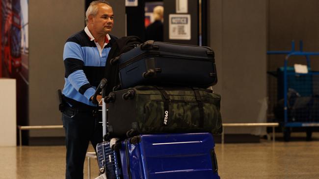
The Gold Coast Airport resumed services at 6am Sunday morning but there is expected to be disruption to travel schedules in the days to come
Queensland Airports chief operating Officer Marion Charlton said the decision to reopen had been made in consultation with airlines.
“As soon as it was safe, our teams returned to inspect the aerodrome, apron, and airport precinct to ensure we can safelyresume operations once weather conditions improve tomorrow,” she said.
“With the region now entering the recovery phase, it is essential for us to reopen as quickly as possible, not only for passengersbut also to provide critical access for emergency services and support agencies, including the Australian Defence Force.
“There will likely be some disruptions to scheduled services, so we encourage passengers to continue to monitor the status of their flight via their airline before heading to the airport.”
Public transport is yet to resume, with both buses, trains and the light rail remaining offline across the weekend. None will not resume on Monday.
Premier David Crisafulli said Gold Coast public transport would be reactived “as soon as possible”.
Many of the Gold Coast’s shopping centres have also reopened with reduced hours but many retailers remained shuttered on Sunday.
Residents and visitors are urged to ensure they are staying up to date with the latest updates as the Gold Coast is expecting strong winds with significant gusts and possible heavy rain into Monday.
“For everyone’s safety keep an eye out for hazards, drive to conditions and stay alert to current warnings,” a council spokesman said.
The Council will assess damage to trees and infrastructure and crews are continuing to respond to priority incidents when safe to do so.
Since Wednesday at 3pm there have been more than 450 incidents reported to the Council.
Mr Tate was booked to fly into Brisbane late on Friday night in a bid to return from his private holiday – he was in Las Vegas for the start of the NRL season – before Cyclone Alfred made landfall.
At one stage, council sources said the Mayor was considering getting a flight from Melbourne to Sydney and even driving to the Coast.
A council source said: “The Mayor got to Melbourne at 7am yesterday (on Saturday). He got a flight to Sydney arriving at 2pm yesterday.
“He stayed overnight in Sydney and got a flight to the Gold Coast this morning arriving at 10am.”
Arrangements were then quickly made for the Mayor to hold the media briefing at the Disaster Emergency centre at Southport from 2pm.
Earlier media reporting suggesting City CEO Tim Baker had been with Mr Tate overseas was incorrect. Mr Baker has been at disaster management since the event began.
Deputy Mayor Donna Gates has been fronting the media conferences daily since the Cyclone Alfred has south-east Queensland in its sights.
Asked earlier about the Mr Tate’s location, Ms Gates said:
“The Mayor has made several attempts to get home but unfortunately all those flights have been cancelled.
“He is as up to date as I am on all cyclone developments. I have personally spoken to him several times and sent him every situation report as they come through multiple times daily.”
Asked if it was a gamble for a mayor to go to Las Vegas during a cyclone season, Mr Tate said: “Hindsight is a wonderful thing,” he said.
“With looking at the effort with Alfred the plan was to be back last Tuesday. A myriad things with a cyclone, it wreaked havoc with aviation.
“It’s not just national airlines but other airlines as well. I did my best to get back as quickly as possible.
“In one instant I was happy to pay $9500 to go on a flight a day earlier. Then that got mechanical problems as well.
“Now I’m here – came via Melbourne and Sydney, and was intending to drive last night.
“My chief of staff said “don’t do it just drive this morning”.
SUNDAY MORNING
The Gold Coast is making a slow recovery from the impacts of Cyclone Alfred with up to 20 roads closed from flash flooding, more than 112,000 homes without power and drenching rain expected to continue.
Mayor Tom Tate, who has been attempting to get back from the United States after a private holiday, was expected to arrive back in the city at 10.30am after Gold Coast Airport was reopened overnight.
Acting Mayor Donna Gates has been based as the Disaster and Emergency Centre providing daily updates.
Asked about the Mayor, Ms Gates said he was “really sad and deeply concerned” about what had happened to the city.
Good morning from a very wet #goldcoast where ex #TCalfred continues to batter the coastline. @gcbulletinpic.twitter.com/tF6RpsWoAD
— Andrew Potts (@GCS_Pottsy) March 8, 2025
“Things are slightly improving, it’s the first time I’ve been able to say that,” she said.
Only 60mm of rain since 4pm on Saturday had hit the city but 100mm still possible later today along with thunderstorms, she said.
Gold Coast City Council said in a statement on Sunday morning that there would be “boots of the ground” as crews began the mammoth clean-up effort.
“Gold Coasters and visitors will start to see more crews on the ground today with City crews working with members of state and federal agencies on the clean-up,” the statement read
“The City will assess damage to trees and infrastructure and crews are continuing to respond to priority incidents when safe to do so.
“Since Wednesday at 3pm there have been more than 450 incidents reported to the City.
“Nearly 1700 request for assistance have been made to SES with 621 resolved since the start of the event.”
The Bureau of Meteorology is predicting winds of between 50 to 60km/h. The concerns are those gusts can remove larger waterlogged trees.
“The end is in sight. It is still another 24 hours,” a BOM spokesman said.
Ms Gates said schools were expected to remain closed and no public transport would be operating on Monday.
Runaway Bay, Pimpama, Burleigh Waters and Nerang centres operated by council would remain open where people could recharge their mobile phones.
Some services are resuming. Bin collection begins on Monday along with landfill, Ms Gates said. City workers are checking the beaches.

Hundreds of Energex crews are working to restore power with their immediate jobs on essential infrastructure and services like retail shops.
At least 112,303 properties are without power and could remain so for days. This is down from 140,000 homes without power.
The worst impacted suburbs are Labrador (5201), Miami (3900), Burleigh Heads (3624), Tugun (3337), Runaway Bay (3090) and Reedy Creek (2444).
Intense and heavy rainfall is expected to continue blanket the Coast throughout Sunday leading to more river rises and flash flooding.
The heaviest falls have been recorded across the Gold Coast Hinterland with 219mm recorded at Upper Springbrook between 9am on Saturday and 6am on Sunday. Over the same period 205mm has fallen at Little Nerang Dam and 193mm at Hinze Dam. Closer to the coastline, 89mm has fallen at Pacific Pines in 24-hours, Coombabah has recorded 83mm, while Monterey Keys and Helensvale have also seen about 68mm of rain.
The Bureau of Meteorology has flood warnings in place for the Coomera, Pimpama and Nerang Rivers, it also includes creeks across Mudgeeraba, Tallebudgera and Currumbin.
Flash flooding has closed a number of roads:
– Gold Coast Springbrook Road, Mudgeeraba
– Pimpama Jacobs Well Road, Pimpama
– Somerset Drive, Mudgeeraba
– Gold Coast Highway, Arundel / Coombabah
– Berrigans Road, Mudgeeraba
– Hotham Creek Road, Willow Vale
– Gunsynd Drive, Mudgeeraba
– Ruffles Road, Willow Vale
– Hope Island Road, Biggera Waters
– Siganto Drive, Helensvale / Oxenford
– Piggotts Road, Guanaba
– Billiau Road, Guanaba
– Tarata Road, Guanaba
– Birds Road, Guanaba / Maudsland
– Old Coach Road, Reedy Creek / Tallebudgera Valley
– Hardys Road, Bonogin / Mudgeeraba
– Clagiraba Road, Clagiraba
– Cheltenham Drive, Robina
A number of other roads remain closed from damage and downed power lines. There are more than 170 individual unplanned power outages across the Gold Coast affecting thousands of residents.
SATURDAY
The Gold Coast has dodged a bullet with Brisbane now to cop the worst from Cyclone Alfred, according to city leaders and disaster managers.
From 2pm on Saturday, the Gold Coast City Council dropped the order to “shelter in place” and eased emergency requirements on residents and visitors
Asked if the Australian tourism capital of the Gold Coast had dodged a bullet, Ms Gates said: “It’s been the most unpredictable system. I think you are right. Brisbane is now going to get some aftermath that we were expecting here as the southernmost tip.”
Soon after, Premier David Crisafulli revealed the Gold Coast University Hospital’s full power had been restored after it had to rely on a back-up generator. “We’ve got that back to main power which is the difference to getting back to full service or not.”
On whether businesses should reopen, Mr Crisafulli said he “had faith” operators would make the right decision for themselves based on the information at hand. He added: “If you are on the Gold Coast getting around might be a little more difficult than on the Sunshine Coast but you will make the right decisions. Drive to the conditions.”
Two of three Gold Coast evacuation centres had lost power but that was being looked at. Four people had to be taken to hospital with carbon monoxide poisoning from using personal generators inside.
Ms Gates said: “If you have a generator, it needs to be appropriately ventilated and outside. Those people are fine by the way so that’s good.”

There had been no rescues required on the Gold Coast in the last 24 hours, she revealed adding “people were sheltering in their homes and safe and that’s the best news we could have”. Ms Gates on the latest messaging added: “We are not saying stay in place now, simply use your common sense.”
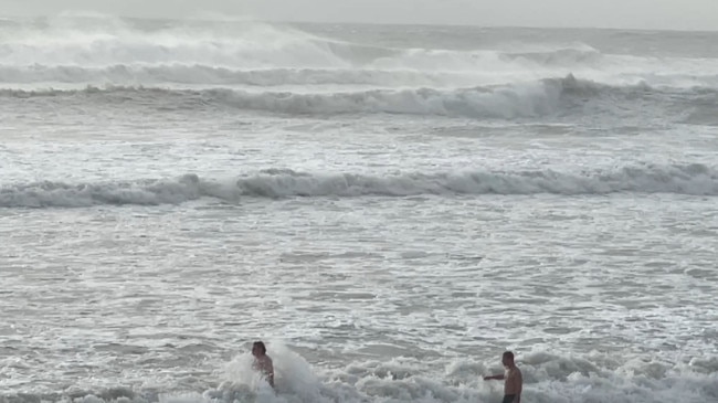
Gold Coasters are being asked to keep an eye out for hazards, as thousands of residents have come out to play after Alfred reached landfall north of the city.
The Bulletin witnessed families taking their young children to walk on Kurrawa beach despite unsafe dunes due to scarping. Others were splashing in suburban skate parks where large trees were unstable.
Major link roads resumed being busy as intersections in Southport, Surfers Paradise, Labrador and Ashmore were chaotic without traffic signals. Some residents visited bowls clubs and craft bars which reopened.
Acting Gold Coast police superintendent Peter Miles urged Coast residents to be careful on the roads. At least 150 signalised intersections are not working.
“There’s a lot of water on the roads. Please do not drive where there’s flooded roads, it is dangerous,” he said.
“We don’t want people coming out early and going to the beaches. It’s still quite vulnerable, that oceanfront.”
Both Supt Miles and Council disaster co-ordination chief Mark Ryan said residents had followed directives overnight which led to no major incidents.
Mr Ryan said: “Thank you Gold Coast. Thank you for heeding our warning and being on that journey.”
In the latest update, once the electricity is restored to the John Flynn Hospital, the Gold Coast Airport will begin operating. The Coombabah wastewater treatment was a priority, currently working off generators.
Other key latest takeaways from disaster managers are:
* Conditions are still dangerous. Heavy rains are expected to continue over the weekend. *Expect more flooding of waterways and in low lying areas as heavy rain continues to fall.
* More than 119,000 properties on the Coast are without power.
Police have closed The Spit due to hazardous conditions. People are stay away from coastal areas for your own safety.
* About 500 incidents were reported to the City since Thursday with staffers beginning to respond to the incidents.
* 801 requests for assistance made to SES since Thursday afternoon.
* Widespread power outages continue to grow with about 131,000 households impacted currently.
* At least 122 people were in evacuation centres overnight.
In a welcome step towards restoring normality, the Gold Coast Airport will reopen at 6am Sunday morning after being closed for three days.
Queensland Airports chief operating Officer Marion Charlton said the decision to reopen had been made in consultation with airlines.
“As soon as it was safe, our teams returned to inspect the aerodrome, apron, and airport precinct to ensure we can safely resume operations once weather conditions improve tomorrow,” she said.
“With the region now entering the recovery phase, it is essential for us to reopen as quickly as possible, not only for passengers but also to provide critical access for emergency services and support agencies, including the Australian Defence Force.
“There will likely be some disruptions to scheduled services, so we encourage passengers to continue to monitor the status of their flight via their airline before heading to the airport.
“For anyone driving to and from the airport, please be careful on the roads.
The Council says there are currently no issues with the quality or continuity of drinking water on the Gold Coast.
Major assets like the Coombabah wastewater treatment plant and Gold Coast University Hospital are working off generators and remain a priority for power fixes.
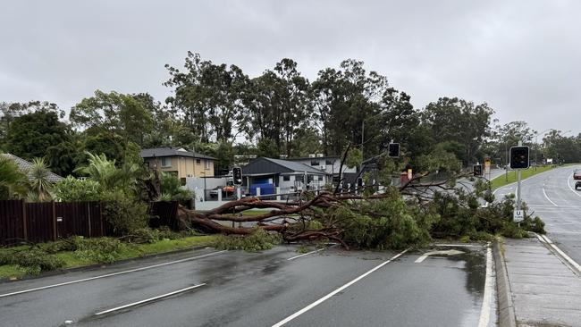
Meanwhile, the Council has received hundreds of reports of fallen trees blocking roads and minor flooding has occurred resulting in road closures across the city.
Both Currumbin and Tallebudgera creek catchments were significantly impacted and council is monitoring catchment areas, given the Hinze Dam is overflowing. There may be further alerts about flooding there.
Residents can report damage to trees, roads or sewerage and water infrastructure via Report a problem or the City of Gold Coast App.
Residents have been spotted removing tree debris. Disaster teams are concerned some of the rubbish may have power lines under it.
Fallen power lines should be reported immediately to Energex.
The City has three evacuation centres at:
* Runaway Bay Indoor Stadium, Sports Drive, Runaway Bay
* Burleigh Waters Community Centre, 111 Christine Ave, Burleigh Waters
* Pimpama Sports Hub, 139 Rifle Range Road, Pimpama
EARLIER
Acting Gold Coast Mayor Donna Gates has warned the worst is still to come after the city experienced a horror cyclonic blast of wind and rain overnight.
“The next 24 to 36 hours could be worse. So we are not through this yet. That’s really important. People are already out starting to walk,” she said.
At first light on Saturday morning, the winds had dropped and only light rain occurring in many Coast suburbs.
Cyclone Alfred was crossing the Coast, headed north of the Coast and the fear for City disaster teams is residents will no longer “shelter in place”.
Wind gusts intensified dramatically after 10am or so whipping up debris and creating dangerous conditions.
At Kurrawa Surf club police were forced to shut old Burleigh Rd as a large piece of metal from a tower construction site swung in the breeze, threatening to break loose and fall.
Down the road at the Langham Hotel bystanders watched on as a window on the top floor had broken free and was flapping violently in the wind.
The Gold Coast Seaway is recording wind gusts of more than 75km/h, similar conditions are unfolding along the Coastline.
Despite the dangerous conditions, parents are still taking their children down onto the dangerously eroded beaches at Surfers Paradise. “It’s going to get worse, that’s what it (all the weather information) tells us. It was also suggested the southern impacts would be worse before and after,” Ms Gates said.
She said the heavy rain would continue on Saturday and Sunday and the combination on the “southern side” of the unprecedented weather system create the potential for “heavy rain, huge thunderstorms and possibly up to 250mm of rain in six hours”.
“That’s massive,” Ms Gates said. “Areas are already saturated, that’s a problem. And the thunderstorms could create wind gusts in excess of 120km/h.”
Ms Gates again warned residents and visitors not to go down to the beach “to take selfies”.
“A lot of the infrastructure has been undermined. We haven’t lost our lifeguard towers yet, but we are pretty close. The structures might look all right on the top but underneath the foundations are gone. “We just want people to stay safe.”
Ms Gate confirmed 25 residents were evacuated from Labrador overnight.
Police evacuated a damaged Frank Street complex.
About 122 people have sought shelter in three evacuation centres across the city, Ms Gates said.
Major riverine flood alerts occurred for Tallebudgera and Currumbin creeks overnight but those warnings have been lifted.
“It’s now just watch and act. It’s eased there as well,” Ms Gates said.
City crews will attend to removal of debris and Energex crews to attend power outages when “safe to do so”.
Photographs on social media show major link roads like Smith Street covered with debris.
Premier David Crisafulli in an update before 8am said Energex crews with up to 1200 workers were “ready to rumble”.
“We are currently approaching a quarter of million homes without power.
That’s the single biggest loss we have in over a decade since (Cyclone) Oswald.
“The work needed to reconnect that is significant, but the ability and desire of the men and women who will do it is without peer,” he said.
The Premier said several key pieces of public infrastructure remained a priority including the Gold Coast University Hospital which was working off generators. He said it was important to urgently reconnect power to the hospital.
He added that no homes had storm tide flooding with homeowners being spared from that danger.
Mr Crisafulli said he wanted to thank residents who had never confronted a cyclone before and “did exactly what was needed” by staying inside.
“There remains a real risk of flooding in the days ahead. But this isn’t anything this part of the State hasn’t dealt with before,” he said.
“It’s a challenge that Queenslanders have risen to time and time again. And it’s a challenge they will rise to yet again this time.”
City of Gold Coast has issued a “too dangerous to leave” alert for Tallebudgera residents with “unpredictable flooding occurring near Tallebudgera Creek.
Southern Coast residents are also advised to monitor conditions for flooding in the Currumbin Catchment.
“Destructive winds from Tropical Cyclone Alfred are easing, however flooding may occur across the weekend,” City of Gold Coast said, in its latest update.
Residents can get full details by visiting dashboard.cityofgoldcoast.com.au.
The BOM on Saturday morning advises:
Damaging wind gusts of up to 120 kilometres per hour are occurring now.
Destructive wind gusts of up to 155 kilometres will persist until early Saturday morning. These will start along coastal areas of the northern Coast.
Heavy to locally intense rainfall may lead to dangerous and life-threatening flash flooding which is likely to develop from this afternoon. This will continue during the weekend.
Abnormally high tides and damaging surf could cause flooding following last night’s high tide.
The hinterland was swamped with rain overnight.
Springbrook recorded 245mm and Upper Springbrook recorded 224mm with Tallebudgera receiving 211mm of rain.
Just after 5am, the Bom said Tropical Cyclone Alfred had weakened and the cyclone warning had “dropped for the Gold Coast”.
Alfred had become a category 1 system about 55kms north east of Brisbane and in by 6am was expected to be below a cyclone threat.
“It doesn’t mean the threat has eased with severe weather warnings are current for much of southeast Queensland for heavy to intense rainfall and seriously damaging to locally destructive winds to thunderstorms in this evening,” a Bom spokesman said.
Almost 100 roads have been closed on the Coast.
The City is warning residents to continue to “shelter in place”.
The Coast overnight has copped the brunt of Alfred heading towards landfall.
At least 119,022 homes have lost power, out of total of 239,564 properties in southeast Queensland.
Burleigh MP Hermann Vorster reaching out to residents overnight on social media was told horror stories.
“My patio roof looks like it going to let rip. Got front view watching all the trees lined up on parkways shifting violently Let’s hope it holds,” a resident said.
At Tugun, a resident described the weather as “wild and scary” with power checking in and out. Another watched a Norfolk Pine tree at Palm Beach being “shredded” with debris across the street.
EARLIER, 9PM FRIDAY: Chaotic damage is lashing the Gold Coast amid widespread power outages, flooding and falling trees as incoming Cyclone Alfred’s blasting of the Australian tourism capital begins.
Gold Coasters were urged to get inside and shelter by 4pm via a Gold Coast City Council emergency alert ahead of high winds inbound and warnings of heavy rain, wild wind and potentially fatal flash flooding as the tropical Category 2 cyclone bears down on the southeast Queensland coastline.
An emergency alert for dangerous flash flooding has been issued on Friday night for Currumbin Valley – with residents told it is too late to leave and they must get to higher ground where they are.
The dangerous flash flooding is impacting Currumbin Creek with Currumbin Creek Road cut by floodwaters in several sections.
Water at the Currumbin Creek water level gauge is now at 46.66m and rising – more than 1.9m above usual creek level.
By Friday evening, wind gusts of up to 107km/h had been recorded at Gold Coast Seaway and 100/h at Coolangatta.
The intermittent showers from earlier in the day had also made way for unrelenting sideways rain.
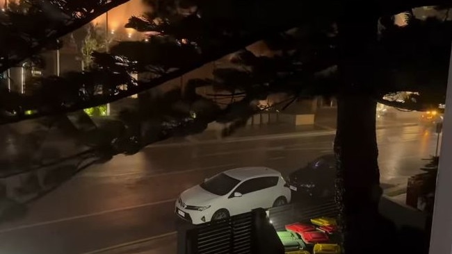
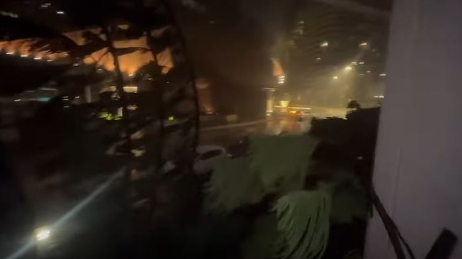
Widespread damage is being reported in Surfers Paradise.
A Gold Coast Bulletin reporter heard a loud ripping noise and saw a corrugated iron roof had blown into a car park only meters from their balcony on Friday night.
Lou James posted on the Surfers Paradise Facebook page: “Huge bang just now in car park outside Mantra on View. Unsure what it is that’s broken into pieces.”
Harrison King responded: “Rain got into a car and exploded the wiring in the building across from it and I saw it happen.”
Mickey Ross added: “I can see parts of the dome on top of the Moroccan breaking.”
Photos show large chunks had been ripped from the domepiece.
Multiple residents are reporting flashes of green and blue momentarily lighting up the sky in what are suspected to be power outages impacting large parts of the city.
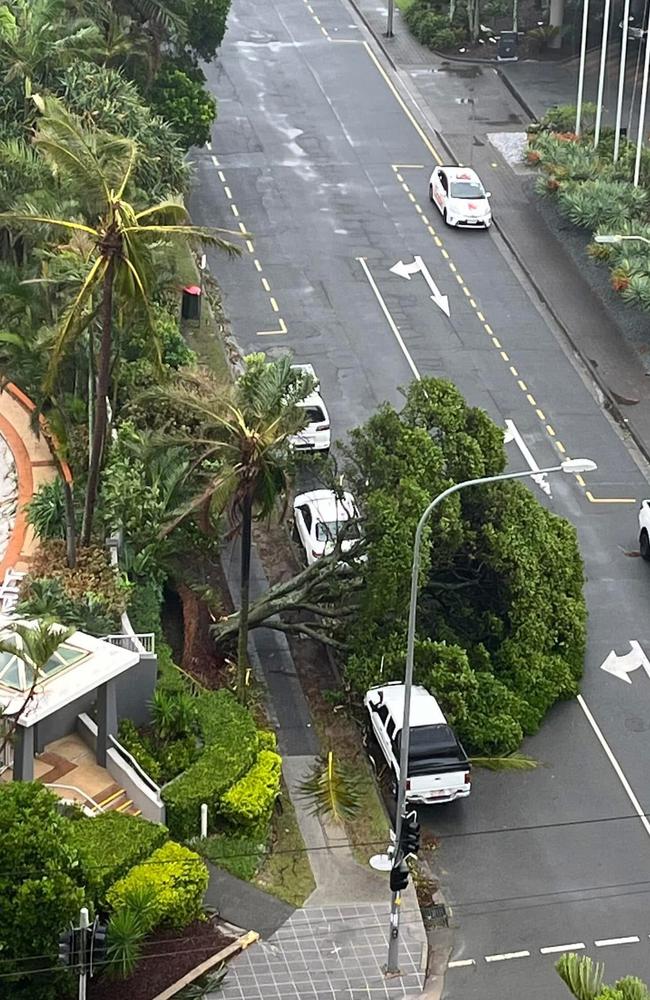
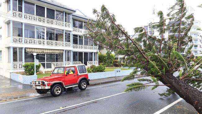
On Old Burleigh Road a 100ft Norfolk tree has fallen into a block of apartments near Jewel – Michael Spurge posted a video showing the harrowing experience to Facebook.
“Looks like our tree is about to fall down. It’s coming down, get ready to run, don’t know where too but …”
Video showed dramatic footage of the huge tree crashed into Mr Spurge’s balcony.
Sounds of screaming could be heard followed by “where’s the puppy grab the puppy.”
“Holy f*** the trees down!”
EMERGENCY NUMBERS
● FOR EMERGENCY HELP IN FLOODS AND STORMS, CALL THE QLD SES ON 132500.
● FOR FALLEN POWERLINES, SHOCKS CALL ENERGEX ON 132 962
MORE TO COME
EARLIER: RED ALERT TO GET INSIDE BY 4PM:
Gold Coasters have been asked to shelter in place immediately as disaster chiefs warn the city is headed to a “red emergency situation” as Cyclone Alfred closes in on the coast.
Local Disaster co-ordinator Mark Ryan issued the warning at a media update at 2pm on Friday with everyone required to be indoors by 4pm.
People have still been out and about around the city, with a Bulletin reporter in Surfers Paradise noting “still a surprising amount of people out” just after 5pm. One chap sat on the beach edge staring at the wild surf conditions for 30 minutes just before dusk.
In wild scenes, at about 7.30pm in Surfers Paradise, multiple people were filmed walking along the beachfront amid high-strength winds, three hours after the alert to stay inside.
Mr Ryan said Cyclone Alfred was expected to cross the coastline at midday on Saturday after hitting Moreton islands in the morning, but destructive winds and rain would begin to ramp up later this afternoon on the Gold Coast.
“In the next hour or so the Gold Coast will move towards an emergency warning, our red highest level warning.
“We are asking people to shelter now. It’s possible we are going to ask people to shelter for 24 to 36 hours.
“That’s because particularly around coastal areas we could see destructive gusts of over 155km/h before, during and after this system crosses to the north of us.”
● ARE THE GOLD COAST’S HIGHRISES/CRANES CYCLONE PROOF?
● MAN SWEPT AWAY IN NORTHERN NSW FLOODWATERS
● WHERE IS MAYOR TOM TATE? ACTING MAYOR GATES OPENS UP
● CYCLONE PROMPTS PRIME MINISTER TO CAN ELECTION
Winds had reached 120km/h in coastal spots. Despite the warnings, dozens of people, many of them tourists, were on Surfers Paradise beach taking photographs with their mobile telephones.
At 4pm, in an update, a City spokesman said: “Already, the City has received approximately 285 incident reports, mostly for fallen trees, the SES has received 348 requests for assistance and Queensland Police have received around 60 requests.
“There are more than 60 road closures current due to fallen trees and localised flooding and this number will increase in coming days.
“The City asks anyone to report damage to trees, roads or sewerage and water infrastructure to www.cityofgoldcoast.com.au/ReportAProblem or the City of Gold Coast App.
“If you see a fallen powerline, report it immediately by calling Energex. Do not touch a fallen powerline directly or with another object.”
Multiple Gold Coast surf lifesaving towers were on the cusp of falling into the ocean, with huge escarpment of the beach edge – with a Spit lifeguard tower teetering midafternoon.
More than 39,000 people have lost power across the city. Many are accessing evacuation centres.
Meanwhile, dozens of mobile network towers have been knocked out of action due to power outages leaving thousands without mobile or internet access on Friday afternoon.
Telstra has confirmed some of its mobile phone sites do not have back up generators and may not be restored until the lines are repaired. The issue has also affected the Optus network.
Suburbs where coverage is affected include Mudgeeraba, Tugun, Currumbin, Varsity Lakes, Bonogin, Merrimac, Worongary, Carrara and parts of Burleigh.
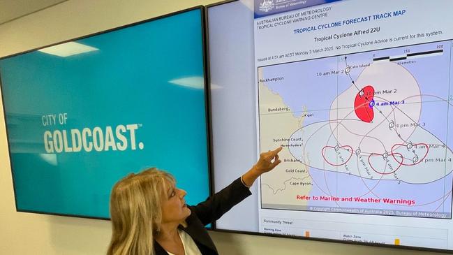
Acting Mayor Donna Gates said: “I can tell you that the width of eye has been measured, and Tropical Cyclone Alfred is now 88 kilometres across the western end of the eye, and 40 kilometres away from the coastline.
While the majority of the people were doing the right thing, Mr Gates said it was unbelievable that some people were removing sandbags holding up signs to stop traffic from accessing a dangerous road at Main Beach.
“We are in an emergency situation here. Everyone has been so good, all the agencies in doing everything they can, and for people to put other people’s lives at risk is just pure stupidity,” she said.
“We have seen it in the water, and now we are seeing it where signage warning people of road closures, because a road is underwater, is blowing away because the sandbags are being removed.
“You can’t imagine what enters someone’s head to think that’s an okay thing to do in these circumstances.”
The City has three evacuation centres open as a last resort with 68 people at them at last count. They are at:
* Runaway Bay Indoor Stadium, Sports Drive, Runaway Bay.
* Burleigh Waters Community Centre, 111 Christine Ave, Burleigh Waters
* Pimpama Sports Hub, 139 Rifle Range Road, Pimpama.
A City spokesman said anyone attending an evacuation centre should ensure they have basic toiletries, medication, personal identification and other documents, a change of clothes, sleeping bag or blanket, water bottle, towel, snacks and light meals, games for their kids.
“You can bring your pets with you, but they will be kept in a separate location and cared for by Animal Management,” the spokesman said.
All beaches are closed and people were again warned to stay away from the foreshore.
8000 homes at risk of flooding
More than 8000 Gold Coast homes are at risk of flooding from Cyclone Alfred.
The City of Gold Coast released new mapping late on Thursday and, in a worst-case scenario, 8200 properties are forecast to be impacted.
The mapping, which aims to give residents notice before the cyclone crosses the coast, previously showed about 6000 homes could expect some water entering their property.
By 2pm on Friday, 68 people were in evacuation centres.
The most impacted suburbs remain in the north, with Paradise Point, Southport and Surfers Paradise facing the brunt of flooding.
Acting Mayor Donna Gates said the City was keeping a watch on those suburbs along with Elanora in the south. Roads were flooded in the hinterland by midmorning Friday.
The suburbs most impacted by outages include Coolangatta (3980), Burleigh Waters (2055), Mudgeeraba (2377), Bilinga (1119) and Reedy Creek (963).
Premier David Crisafulli said the system had “packed a punch” overnight on the southern Coast with winds of 100km/h.
“We believe it’s a system as a State we can handle,” he said, in an update on Friday morning.
He said water rather than wind was the big future challenge and was the “sting in the tail”.
Water spilt over the Hinze and Little Nerang dams overnight after creeping towards 100 per cent late in the week.
The level at Hinze Dam is 100.8 per cent and 100.3 per cent at Little Nerang Dam. Hinze is ungated and waters spills over once the dam reaches capacity.
Residents in those potentially flooded catchment areas are being urged to keep watch and remain off the roads.
Hinterland-based councillor Glenn Tozer said more than 4500 homes had lost power in his council division which extends west of the Pacific Motorway from Mudgeeraba to the border.
He has received numerous reports from residents after trees fell on their homes.
A large tree had smashed a granny flat on a property at Benogin overnight.
“No-one has been injured. The family have been offered emergency accommodation,” Mr Tozer said.
Residents on his Facebook page asked if they could visit opened shops.
“Please stay at home if you can. Lots of danger currently from flying branches,” Mr Tozer told them.
Queensland Fire Department crews overnight responded to reports of trees down on a house and cars at Tallai around 8.15pm.
The City spokesman in updated advice to residents warned there would significant damage to infrastructure and trees across the Coast in the coming days.
“City crews are not able to respond to impacts from TC Alfred at this time due to safety concerns. Crews will respond to priority incidents as soon as it is safe to do so,” the spokesman said.
Residents can report any damage to trees, roads or sewerage and water infrastructure to cityofgoldcoast.com.au/ReportAProblem or via the City of Gold Coast App.
“It may take days or weeks to respond to all reported impacts. We appreciate your patience at this time,” a spokesman said.
Police began closing down major hinterland roads. Somerset Drive was blocked off from after 9am due to large amounts of water across the road.

Gold Coast Acting chief superintendent Peter Miles said: “I’m staggered to see some of the footage I’m seeing of kids.”
At least 2909 homes are without power, most in the hinterland. Energex was working to restore power until it was unsafe for workers.
Ms Gates urged residents to “fill their bath tub” because there could be an interruption to water supplies or contamination. “It’s going to be important you’ve got fresh water.”
City beaches were being eroded, up to 2.5m in some locations, with Surfers Paradise to Narrowneck worst affected.
Mr Ryan said the preparation window was about to close with movement now into a response phase.
“Do not focus on the crossing time for Gold Coasters. It’s not a good guide based on our threat,” he said.
“Our threat will start to begin from (Thursday), escalate into tomorrow, and into Saturday and likely not to ease until late Saturday evening or into Sunday.”
At 2.30pm a prepare to shelter warning was again issued, with the recommendation that by 7pm people “bunker down for the event”.
Council CEO Tim Baker, in a briefing with Police Minister Dan Purdie at Southport’s Disaster Co-ordination Centre, earlier on Thursday pointed to the seawall and its reliance as being a vital test as Alfred approaches the Gold Coast.
Mr Baker singled out Narrowneck in the north as a hot spot for beach erosion. Other areas include the gaps at Mermaid Beach and Palm Beach where there aren’t certified walls.
“We need to steady ourselves for weeks – no matter what happens,” he said.
Mr Baker pointed to the importance of the boulder wall, approved by the State Government in 1967, which runs parallel to sand dunes along the entire Coast coastline. Since the 1980s the council has aimed to build a continuous beachfront protective wall along 52km of coastline, apart from the headlands. To achieve it requires about 8.9 km of private seawalls be built.
“This is our first test of the A-line, how it will hold. We as a City as doing continual work with it,” Mr Baker told Mr Purdie. “We are copping it the most – this is Narrowneck. It is going to fall back to the A-line.”
Mr Purdie told Mr Baker and Local Disaster co-ordinator to “keep up the good work”.
The City provided the following updates:
● Non-critical City of Gold Coast services including waste collections closed on Wednesday will not reopen until at least Monday due to the expected impacts of Tropical Cyclone Alfred.
● The Nerang evacuation centre closed with council opening up at the more modern Pimpama Sports Hub facility. Other centres are the Runaway Bay Indoor Stadium and Burleigh Waters Community Centre.
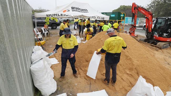
● More than 45,000 sandbags have been distributed with stations open to 5pm on Thursday.
Gold Coast City Council has extended its closure of services until at least Monday after initially only planning a two-day suspension through Friday.
The Coast’s remaining major shopping centres closed their doors late on Thursday afternoon ahead of the heavy downpour expected on Friday before Alfred makes landfall in the early hours of Saturday morning.
However many supermarkets and smaller venues are expected to remain open for the time being on Friday.
Tropical Cyclone Alfred’s path slowed significantly overnight, pushing back its expected landfall time, with experts saying the slowdown was “most likely bad news”, as billions of dollars worth of damage is expected.
EARLIER:
The Gold Coast acting Mayor Donna Gates is warning complacent residents to stay off beaches and heed warnings as Cyclone Alfred slows its approach – but remains as intense as ever.
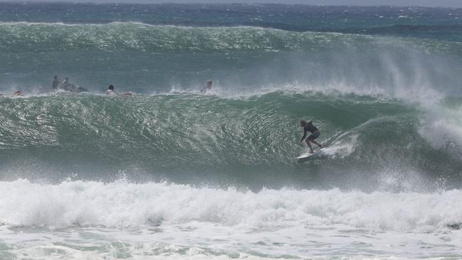
Swimmers were risking their lives at beaches on Thursday morning after record breaking waves reached more than 15 metres overnight, as Cyclone Alfred stalled off the Coast
The City and Queensland Police Service have responded by warning officers will hand out on-the-spot fines of up to $16,000 for reckless behaviour.
Acting Gold Coast Mayor Donna Gates said Cyclone Alfred had not lost intensity and people need to stay away from the beaches.
“Definitely don’t go in the water. Stay away from the beaches, stay away from the rock walls, and listen to us,” she said.
“This morning there was a 12.3 metre wave at Main Beach. It’s incredibly dangerous. The highest wave off the Tweed was 15 metres yesterday.”
Premier David Crisafulli on Thursday morning confirmed a 12.3m wave had been recorded off Main Beach overnight.
The predicted crossing late into Thursday was now extended to Friday, he added.
“They are standing on the edge of the shore. The sand has given way to erosion.”
Ms Gates said there had been significant beach erosion on the Gold Coast.
“We were advised last night that there were waves up to 15.2 metres high at the Tweed. That is staggering. The swell is huge. The beaches are closed along the coastline. Please don’t go to them.”
The messaging from authorities has been to shelter in place but with better weather many are venturing out, to get final supplies.
But hundreds of Gold Coasters are using the window of delayed bad weather to visit headlands.
Crowds were packing Burleigh Heads where pro-surfers were testing the waves.
“The messaging changed a little overnight. We were urging people to shelter in place. But overnight it was suggested that people should monitor the weather as far as going to get shopping, then travel in accordance with the weather,” Ms Gates said.
The wind speeds are expected to get to 120km/h late on Thursday afternoon.
“That will be a time when people need to stay home,” she said.
The City on Thursday opened up DIY sandbag sites. The hours are 11am to 5pm.
The sites are at the Carrara Sports Precinct and Tugun Village Community Centre.
Residents need to bring their own shovel and fill the sandbags. Up to 10 bags per customer are available.
“Please only travel to sandbag stations if it is safe to do so,” the City said.
Key warnings from City of Gold Coast on beaches:
* the Coast is currently subject to a Disaster Declaration which gives police additional powers to ensure community safety. Reckless actions by members of the community may result in them facing a fine of up to $16,100.
* everyone should stay away from the water’s edge and the rock walls and piers after a series of close calls.
* No photograph or video is worth your life. Increasing winds will see conditions deteriorate further and become more dangerous.
* all beaches are closed because of these dangerous conditions
* police will continue to conduct patrols of these locations to prevent this sort of dangerous behaviour.
EARLIER:
Significant flooding is about to occur to Gold Coast waterways with the potential storm surge from Tropical Cyclone Alfred now likely to be greater than a metre.
The latest disaster briefing at 2pm said the cyclone was 315km east of the Coast and expected to cross just north of Brisbane on Friday morning.
It means the city will be one of the worst impacted with the cyclone’s southern part to have the strongest winds and rainfall.
Weather models show winds of “around 90km/h to 130km/h” and a “worst case storm surge of over a metre”.
Premier David Crisafulli after visiting businesses at Paradise Point in his Broadwater electorate in the afternoon said the message was clear to residents.
“And that is do to the preparation now, and I want to thank those businesses that are heeding the warning and I want residents to do the same,” he said.
Mr Crisafulli said Alfred was continuing to head towards the Coast as predicted, and likely to cross in the late hours of Thursday into the early hours of Friday.

“I want to stress why it is so important to do the preparations now. There is the prospect this cyclone could cross the Coast in the middle of the night with a high tide. That is not the time to be making your evacuation plan.
“Now is that time. If you do so, I have every faith that Queenslanders will be safe.”
The Premier said the arrival of 176 police officers on the Coast was a sign of how serious the cyclone was being taken by authorities.
“In many cases those police will be going door to door. They will also be there to make sure the logistics that are needed are on the ground,” he said.
“If someone turns up to your door — they are there because it’s important, and you are important. Of course you should do all the preparations to protect your property — humans are worth more than any other material possession.”
Acting Mayor Donna Gates said the cyclone would be a “high end Category 2” with wind gusts similar to a Category 3.
“The system is intensifying,” she said, adding Alfred would make landfall between Caboolture and Tweed Heads early Friday morning.
“The gale force winds are likely to increase tomorrow night, we need people to make sure they are safe in their homes from six o’clock night. They also need to plan for power outages.”
The beaches remain closed and residents along with visitors are being warned to stay away after some took to the surf on Wednesday.
“Conditions tomorrow are going to be awful, with gale force winds and heavy rainfall,” Ms Gates said.
“Much of the focus for rainfall will be between Southport and Byron Bay.”
An emergency alert for Gold Coast residents on Cyclone Alfred warns that significant flooding could occur from 6pm on Wednesday. It would start during the evening.
Local Disaster co-ordinator Mark Ryan said the warning strategy had moved to the next stage in releasing alerts about flooding. Residents can go to the Gold Coast City dashboard and sign up for the alerts which will give immediate notice of floodwaters.
“This has allowed the push notification to be sent and received by all of those in the coastal area, It’s another warning strategy we’ve done, it’s from tonight,” Mr Ryan said.
The warnings, across the southeast Queensland coast include six hourly rainfall of between 60mm and 110mm and 24 hour totals between 80 and 180mm.
This may lead to “dangerous and life-threatening flash flooding,” authorities warned.

The Queensland Police Service in early afternoon said 176 extra officers were being deployed on the Gold Coast for Cyclone Alfred.
Acting Police Commissioner Shane Chelepy praised the co-operation between officers, staff, volunteers, and emergency services partners.
“With Tropical Cyclone Alfred still approaching, QPS has already mobilised 176 officers and recruits to assist on the Gold Coast, and we stand ready to deploy further resources as required,” Acting Commissioner Chelepy said.
Meanwhile, Transport and Main Roads announced rail services would be suspended after the last scheduled runs this evening.
Passengers were being encouraged to visit TransLink for updates. Residents were again advised not to use roads on Thursday.
At least 663 schools have been closed, including State campuses and independent schools on the Gold Coast. Details are available at https://closures.qld.edu.au/
The QPS and the City of Gold Coast released warnings on flooding. Hot spot suburbs for flooding are Paradise Point, Surfers Paradise and Elanora.
The QPS in its alert said: “Significant flooding along waterways is expected to start tonight. Check the Disaster Flood Risk Map. If you are in a risk area, decide now where you will take shelter.”
Gold Coast City warned Cyclone Alfred was moving towards the Queensland coast and destructive wind gusts and significant flooding was forecast to start by 6pm.
“Everyone should take shelter at home or in a safer place by 6pm,” the City said.
“If you have been told to evacuate or you do not feel safe in your home, ensure you are in a safer place by 6pm, ideally with family or friends.
“Evacuation Centres should be a last resort, shelter with family or friends first. If you are not in a flood risk area, your best option is to shelter in your home.
EVACUATION CENTRE LOCATIONS
* Runaway Bay Indoor Sports Centre (Sports Drive, Runaway Bay), open now.
* Nerang Bicentennial Community Centre (833 Southport Nerang Road, Nerang)
* Burleigh Waters Community Centre (111 Christine Avenue, Burleigh Waters). Both open from 5pm.
EARLIER:
Gold Coasters must brace themselves for three distinct hits from Cyclone Alfred – starting Wednesday with high winds before a tidal surge and heavy rain leading to flooding by weekend.
The latest briefing just after 8am on Wednesday included advice that cyclone will cross just north of the Coast with “models bringing it further south” than before.
Both the storm tide surge risk and wind velocity has been upgrade.
Mudgeeraba councillor Glenn Tozer at an earlier private disaster management briefing asked City officers how the unprecedented weather event will unfold across in the next few days.
He was told of there would be “three distinct stages”.
The first will be high winds, from midmorning on Wednesday continuing until Friday.
Latest overnight modelling shows winds strengthening, predicted to be between 120km/h to 155km/h.
“The next stage will be a tidal surge and rain at the same time,” Mr Tozer told the Bulletin.
The storm surge is expected on Thursday after midday and will continue into Friday, after Alfred makes landfall.
“It will be bucketing down with rain when the tidal surge occurs,” Mr Tozer said.
The flooding will then kick in because the flood waters – particularly in hot spot suburbs like Paradise Point, Surfers Paradise and Elanora – cannot escape.
“All the water that normally flows out to the ocean will sit for a stage. People will be flooded,” Mr Tozer said.
This final phase is expected to last from Thursday through to Sunday.
“The good news is all modelling seems to indicate the cyclone will pass over and head out west without hovering over the city for an extended period of time. Rain and wind conditions are expected to subside by Sunday,” Mr Tozer said.
Acting Mayor Donna Gates on Wednesday said overnight updates suggested there would be increase in storm tidal surge.

“It will still remains a watching brief. It is not looking good for our city,” she said.
Evacuation centres will open on Wednesday afternoon.
“I’m sure this is not being exaggerated in any way. This is very real,” Ms Gates said.
“Coming off line with the Premier (David Crisafulli), he is urging every agency to try and get the message through that this is a major system, heading our way and it will most definitely cross the Coast. It is inevitable, and we need people to understand that.”
The City has evacuated three families form South Stradbroke Island. At least 65 people remain there.
“There is still work going on, over there, getting people off the island. Today is the last opportunity for voluntary evacuations,” Ms Gates said.
The City in its latest update says waste collections will be suspended on Thursday and Friday as winds are expected to be strong enough to blow bins away and create debris.
From Sunday the City will locate skip bins in areas that missed their Thursday or Friday collections as an option for excess waste, weather permitting.
Residents are urged to be prepared to shelter in place for some time and ensure power banks and devices are fully charged.
More information about how you can prepare for a cyclone can be found on the Get Ready website – www.getready.qld.gov.au/news/tropical-cyclone-alfred-march-2025.
For the mapping and to stay up to date visit dashboard.cityofgoldcoast.com.au.
EARLIER (TUESDAY UPDATES) ‘It’s Scary’ – Acting Mayor assessment:
The Gold Coast is set to cop a greater hit from Tropical Cyclone Alfred than Brisbane or the Sunshine Coast as the city braces itself for the most severe weather event in more than 70 years.
The forecast, which Acting Mayor Donna Gates warned was “scary”, shows the Gold Coast in line for more than 700mm of rain across three days, with up to 1000mm expected to fall in the Hinterland.

FULL CYCLONE COVERAGE:
DAYS WITHOUT POWER, 600K HOMES AT RISK, METRE OF RAIN: TC ALFRED’S PATH OF DESTRUCTION
FLASHBACK: WHEN CYCLONES DEVASTATED GOLD COAST’S BEACHES
CYCLONE ALFRED: WHICH GOLD COAST EVENTS HAVE BEEN CANCELLED
WHAT SHOULD I PACK? HOW DO I PREP HOUSE? QLD CYCLONE SAFETY GUIDE
MUST SEE: NEW MAP SHOWS ALFRED’S IMPACT ON PROPERTIES
WE ASKED FOUR EXPERTS ABOUT TC ALFRED. THEY ALL AGREE ON ONE CONFRONTING SCENARIO
At least 6000 homes in the firing line for either flooding or storm surges, new council flood modelling shows.
Ms Gates said the cyclone, which is expected to make landfall between Brisbane and the Sunshine Coast on Thursday night, was expected to be the city’s worst weather event since the “great Gold Coast cyclone” of 1954.
“This is expected to be the most significant system since 1954 – it’s not a good outcome for the Gold Coast,” she said.
“It’s important that the community have a good understanding of what we are dealing with. We don’t want people to be lulled into a false sense of security.
“Every scenario that has been modelled indicates it’s not a good outcome for our city.
“It’s scary. All the modelling indicates Alfred with turn back to the Coast here. There are not scenarios where this will not occur.”
Local Disaster Co-ordinator Mark Ryan stressed that residents needed to have their plans in place by 5pm on Wednesday.
“The scenarios are now shaping up that we will take the southerly impact of this cyclone and it will be a significant event for the Gold Coast,” he said
“The impact is going to be severe – in fact, we were advised that we’re likely to be the most severely impacted area.”
Premier David Crisafulli asked Queenslanders to “stay on their guard” as Alfred intensified to a Category 2 cyclone.

“There is still an element of the population that hasn’t yet fully understood the magnitude of this system,” he said.
“And that’s completely understandable because it has been many decades since Queensland has been here in this part of the state (in terms of a cyclone crossing the coast).
“And I know that people in the South East may not have experienced a cyclone before but they’ve been tested with floods and they’ve come through with flying colours every time.”
The latest tracking path from the Bureau of Meteorology shows the predicted path taking the centre of the Category 2 system over Brisbane’s northern suburbs, with the most intense rainfall expected to the south.
The Gold Coast was on Tuesday battering down the hatches for the tropical cyclone.
In the latest:
* Schools remain open on Wednesday.
* Winds are predicted to be between 130km to 140km. All property owners are being asked to remove outside furniture, with council especially warning high rise residents to clear their balconies.
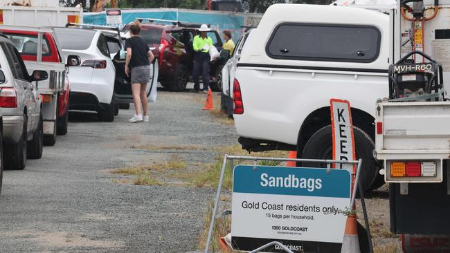
* Opening hours have been extended at sandbagging stations to 6pm on Tuesday – with limits on the number per household. Councils trying to source another 50,000 bags as supplies start to run low.
* Bins will not be collected on Thursday and Friday, with the City asking residents to store them safely. Collections will resume the following week.
* Twenty-six families were evacuated from South Stradbroke Island on Tuesday.
* Police are door knocking homes across northern suburbs, with recruits in the southeast corner conducting door knocks to check on residents in “vulnerable areas”.
* Construction of the light rail’s Stage 3 will pause for the rest of the week in preparation for Tropical Cyclone Alfred’s impact.
The tram network is expected to continue to run through the wet weather but a GoldlinQ spokesman said changes were possible.
“Preparations are underway to manage impacts from severe weather on the Gold Coast Light Rail Stage 3 alignment and to G:link operations,” he said.
Businesses across the city are also taking precautions.
Village Roadshow announced late on Monday afternoon it would close its Gold Coast attractions – Warner Bros. Movie World, Sea World, Wet’n’Wild, Paradise Country, Australian Outback Spectacular and Topgolf – between Wednesday and Friday. Dreamworld is also closing for the period.
The company said in a statement Sea World Resort would remain open.
“We will have critical support team members working over this period to ensure the welfare and wellbeing of the animals in our care,” the statement read.
Parks are expected to reopen on Saturday, with a decision to be made later in the week.
Paradise Country Farmstay will close on Tuesday, while Australian Outback Spectacular’s Friday show has been cancelled.
Gold Coast boat owners are being urged to act quickly, with Acting Chief Superintendent Peter Miles from Gold Coast police stressing that safety must come first as the storm intensifies.
“We do acknowledge that these boats are these people’s lives,” he said.
“But we want to stress boats can be rebuilt, houses can be rebuilt – lives are more important here.”
With conditions expected to worsen by Thursday, Supt. Miles urged boaters to secure their vessels now, not wait until the last minute.
“We ask boaties to look at their situation now and not leave it until tomorrow or Thursday, when things are going to get quite rough,” he said.
Acting Supt Miles said people who live aboard their boats were especially vulnerable, with more than 200 people understood to be residing on boats in the Gold Coast district.
He urged them to check their pumps, secure items on deck, and move boats to safer areas if possible, such as rivers or estuaries that provide natural wind protection.
For boats that cannot be tethered or anchored, Acting Supt Miles advised reaching out to authorities, who are ready to assist and will “try to work out an alternative.”
MONDAY MORNING
“It’s scary. All the modelling indicates Alfred with turn back to the Coast here. There are not scenarios where this will not occur.”
This is the sobering update on Tropical Cyclone Alfred delivered by Acting Mayor Donna Gates early on Tuesday.
“It will be the most significant weather system event since 1954,” she added.
On 20 February 1954, a tropical cyclone crossed over Coolangatta — later called the Great Gold Coast Cyclone — causing serious structural damage to buildings with the surge of waves at Kirra bringing three metres of water onto the highway washing cars from the road.
Authorities are now forecasting Alfred poses a similar threat. The Bureau of Meteorology (BOM) advises it is currently moving southeast, but expected to slow and turn west towards the Queensland coast later on Tuesday.
Alfred is forecast to cross the southeast Queensland coast at category 2 strength late on Thursday or early Friday morning
The latest update from City disaster managers reveals:
* The Gold Coast will be dumped with up to a metre of rain — the predictions are 800mm to 1000mm across three days — from Thursday to Saturday.
* Winds are predicted to be between 130km to 140km. All property owners are being asked to remove outside furniture, but the City’s big warning is to high rise residents to clear their balconies.
* Plans are underway for voluntary evacuation of South Stradbroke Island. Council officers will arrive by barge from 3pm today and encourage residents to leave.
* Extra sandbagging stations are being brought online. Residents can self serve and fill bags at the Carrara Sports Precinct and Tugun Village Community Centre.
* The wait at Pimpama on Tuesday morning was about an hour, with the line-up of vehicles two kilometres long at 8am.
* Bins will not be collected on Thursday and Friday, with the City asking residents to store them safely. Collections will resume the following week.
While City leaders say they are avoiding “being alarmist” their messaging in the past 24 hours is forcing residents to be more prepared than during the shock 2023 Christmas weather event.
Shelves are bare in many shops as residents panic buy essentials. Other retail outlets have been stripped of items like batteries.
The Coast’s disaster and emergency managers along with City leaders overnight have been given a blunt assessment of weather options.
“All current indications are Alfred will turn back to the coastline. There are no scenarios where this does not occur,” the advice says.
Ms Gates told the Bulletin: “All of the modelling says Alfred will cross the Coast.”
Ormeau resident Alison Morrison said she arrived at the Pimpama depot just before 7am and still had a lengthy wait to reach the front of the queue.
“That’s OK – that’s not so bad – I expected it. At least I can see the sign to the entrance,” Mrs Morrison said.
“We flood on a good day. (We’re) preparing and panicking.”
Mrs Morrison said she was taking the warnings seriously and had made the decision early to keep her son home from school to help with preparations.
“We’ve got a lot of outdoor furniture and stuff that we’re packing up and pot plants and things like that. Everyone is telling us now we should be taping up the windows and packing emergency kits if we need to leave the house,” she said.
“You’re better to be safe than sorry, why not prepare? I’m hoping for the best.”
The City will make a decision later on Tuesday on whether is keeps sand bagging depots open from 5pm.
The main locations to get filled bags are:
196 Old Pacific Highway, Pimpama (next to the City of Gold Coast Coomera Depot)
42-44 Boyd Street, Bilinga (next to the City of Gold Coast Tugun Depot)
61 Hutchinson Street, Burleigh Heads (at the Reedy Creek Waste and Recycling Centre)
MONDAY
The Gold Coast is bracing itself for the “worst possible” impact from Tropical Cyclone Alfred with the added fear 130km/h winds and half a metre of rainfall will combine with a night-time tidal surge.
Acting Mayor Donna Gates on Monday said the latest briefing forecasted the cyclone would be a Category 1 or 2 and cross at the Sunshine Coast or Moreton Bay on Friday morning.
“There will be widespread flooding and wind gusts of 90 to 130 kilometres per hour. Now is the time to prepare — clear gutters and secure outdoor furniture,” Ms Gates said.
The Council closed all beaches on Monday morning.
Just 30 people turned up to sand bagging stations on the weekend but a line-up of vehicles had arrived by mid-Monday morning.
A “watching brief” is being kept on major events like the Green Day concert at CBUS Super Stadium on Wednesday, the Gold Coast Festival of Golf and the Gold Coast Suns season opener on Saturday night against Essendon at Carrara.
Ms Gates revealed Cyclone Alfred crossing north of Brisbane left the Gold Coast exposed to stronger wind and rain damage than other areas in southeast Queensland.
“That is the worst possible outcome for our city than if it crossed directly across the Coast,” she said.
“Because the system, the southern impact, is far worst for us than if it crossed north. It’s a watching brief. It can change but it’s not looking good for us.”
Local disaster co-ordinator Mark Ryan agreed that a cyclone system crossing north of the Coast was the worst outcome.
“We know that the worst weather that comes from a cyclone is on the southerly side of the cyclone. We could see 300 to 400 millimetres of rain on one model – if it adjusts we could even see a three-day total exceeding 600 millimetres of rain. That’s a significant concern for the Gold Coast,” he said.
Before releasing more detail, the Disaster team is working on several scenarios including impacts on exposed areas like South Stradbroke Island and canal communities.
The flood modelling will look at high tides with an extra half a metre of water.
“People can get on our website now, on to our City Plan, and actually looks at what our modelling looks like,” Mr Ryan said.
The City was also checking on beach erosion, with no significant impacts so far.
“However, the team have looked at forecasts and are quite concerned about significant amounts of erosion should the forecasted conditions come through,” Mr Ryan said.
Asked if the north suburbs of the City would be more impacted, he replied: “No, the entire city will feel the effects of this system.”
Disaster management teams were keeping a close watch on night tide forecasts.
“It elevates the water further. Some of the detail monitoring we do today will add the rain into that scenario,” Mr Ryan said.
Details of flood evacuation centres are likely to be made available on Tuesday.
“Where you go is the next question. They are typically pretty crowded places. So we would also say, if you have friends and family or others you can stay with you will be a lot more comfortable,” Mr Ryan said.
Businesses across the city are already taking precautions.
Village Roadshow announced late on Monday afternoon it would close its Gold Coast attractions – Warner Bros. Movie World, Sea World, Wet’n’Wild, Paradise Country, Australian Outback Spectacular and Topgolf – between Wednesday and Friday.
The company said in a statement Sea World Resort would remain open.
“We will have critical support team members working over this period to ensure the welfare and wellbeing of the animals in our care,” the statement read.
Parks are expected to reopen on Saturday, with a decision to be made later in the week.
Paradise Country Farmstay will close on Tuesday, while Australian Outback Spectacular’s Friday show has been cancelled.
Police are urging residents to start preparing their homes now with the weather event already beginning to lash the region with strong winds and scattered showers.
Acting Gold Coast Chief Superintendent Peter Miles said: “If we get that rain, and there are talks of up to 600 millimetres of rain, that is a lot of rain already in areas where we have catchments that are fairly full and dams that are full.
“We’re not trying to be alarmist but we are trying to be realists and that is the potential
“Now is the time to act. Don’t leave it till Wednesday or Thursday, it will be here before we know it and you really need to start looking at what you need to do now.
“Look at a 72-hour kit that you can stay off grid should you lose power. Charge everything up now.”
Residents in low lying areas are urged to considering getting sandbags and homeowners should secure any loose items around their properties.
Chief Supt Miles said it was a good idea to reach out to neighbours and have a plan to lookout for each other.
“If you don’t know your neighbours, introduce yourself. You just never know that you might be helping them onto their roof, or whatever assistance they require,” he said.
“We are fairly confident this is going to bring a lot of rain – it’s going to cross land and we need to be prepared.”
Residents living along canals and waterways were of immediate concern to emergency service, police are also closely monitoring conditions for property owners at Couran Cove on South Stradbroke Island.
Additional officers – including recruits – are on standby to assist over the next few days. Chief Supt Miles urged residents to begin conversations with employers around the possibility of working from home to keep unnecessary traffic off the roads.
“It’s that serious, if you don’t need to be out and about please stay at home,” he said.
“Your lifestyle for a couple of days may dramatically change because of where you live of what you do for a living. If we prepare for the worst and hope for the best – I think that is the best attitude to have.”
EARLIER
All Gold Coast beaches were closed early on Monday morning – with early messaging from the City advising of the potential for gale-force winds.
A Council spokesman on Monday said: “All Gold Coast beaches will be closed to swimming today due to a large swell and hazardous conditions. Please heed the advice of lifeguards and stay out of the water.”
The city’s SMS alert system sent messages to locals at 11.30am on Monday, warning them to “prepare now” as “Cyclone Alfred could cross the coast of southeast Queensland from Wednesday”.
Meanwhile, the only Queensland show by ‘90s rock legends Green Day, scheduled for CBUS Stadium on Wednesday night, was still going ahead as of 11am Monday.
On Monday two trees fell at the Gold Coast, one crushing two cars and another causing hours-long outages for hundreds of Energex customers.
Just after 6.30am, a tree fell at the Gold Coast Aquatic Centre and crushed two cars.
A spokeswoman for the Gold Coast City Council said they were aware of the incident and were talking with the owners of the vehicles.
“Nobody was injured and the tree is being removed this (Monday) morning,” she said.
At 8.25am, a tree fell onto powerlines at Bonogin causing widespread power outages.
A Queensland Fire Department spokesman said a fire and rescue crew was quickly on the scene at Smith St, Bonogin, and said some smoke was coming from the site.
The incident caused outages for 104 customers, an Energex spokeswoman said.
She said Energex hoped to have the power restored by 3pm on Monday, but that as Cyclone Alfred approached Queensland’s coast, residents should be prepared for longer outages.
“The combination of gale force winds and flooding can cause extensive damage to the overhead and underground electricity network,” she said.
“Cyclonic winds can blow tree branches and other debris into powerlines, so now is the time to check your yard for anything that could become a dangerous projectile. By securing or stowing items like trampolines and outdoor furniture, you will reduce the risk of property damage and serious injuries.
“Protracted severe weather events can delay our crews, so people need to think about what their household would need to get through a week without power.”
Gold Coast City Council has opened up three sandbagging stations at:
* 196 Old Pacific Highway, Pimpama (next to the City of Gold Coast Coomera Depot).
* 42-44 Boyd Street, Bilinga (next to the City of Gold Coast Tugun Depot).
* 61 Hutchinson Street, Burleigh Heads (at the Reedy Creek Waste and Recycling Centre).
Vehicle line-ups at Reedy Creek were long just hours after opening, at 10am. Residents are being urged to watch for Gold Coast Alerts by visiting the Gold Coast disaster dashboard.
Acting Mayor Donna Gates said: “As a precaution, we’ll be opening the sandbagging stations at Burleigh, Bilinga and Pimpama. It’s suggested that anyone with concerns should get their sandbags ready. We just want residents to be prepared.”
The council said the Gold Coast is experiencing hazardous surf conditions, with abnormally high tides expected in the coming days. “The City is planning for a range of scenarios to allow the community to prepare for any of the severe weather affects which may affect the Gold Coast, no matter the track that Alfred takes.”
Meanwhile, the plumbing peak body is urging residents to inspect their homes as flooding and pipe breakages surge under severe weather conditions.
Master Plumbers Association Queensland (MPAQ) CEO Penny Cornah said it was critical for residents do this as soon as possible to protect their homes.
“Issues such as flooding, pipe breakages and blockages are common in storms, but often overlooked until they cause severe damage and cost homeowners massively in repairs,” she said.

Join the conversation

Alfred’s silver lining: How to get your home checked for free
Gold Coast homeowners can now access free resilience assessments to help better prepare their properties for extreme weather. How to get involved:
Read more

‘Two arms’: The surprise solution to Coast’s eroded beaches
The Gold Coast City Council is investigating a shock solution to protecting the beaches from further erosion after revelations it will be years before they are restored to their pre-cyclone glory.
Read more