
When the Gold Coast’s beaches reopen for swimming after Ex-Tropical Cyclone Seth
Holidaymakers rejoice! Council has opened beaches on the southern Gold Coast for swimming – but say to take extra precautions. SEE WHERE
Gold Coast
Don't miss out on the headlines from Gold Coast. Followed categories will be added to My News.
Gold Coast City Council has opened all beaches south of Burleigh for swimming, but says to take extra caution.
On Wednesday morning council announced all beaches north of Miami would remain closed until noon due to incoming king tides.
It said lifeguards would continue to monitor conditions and close/open beaches as required.
JANUARY 4: Gold Coast City Council says it will reassess beaches later in the week once the conditions following ex-Tropical Cyclone Seth ease.
On Tuesday the council closed all beaches on the Gold Coast for the third day and issued a hazardous surf warning at 4pm.
“There was minor scarping at northern beaches and south Burleigh,” a city spokesperson said.
“Sand nourishment works undertaken by the city in recent years have increased the volume of sand along the coastline, allowing beaches to better withstand erosion during severe weather events.
“The City will commence beach reprofiling works later this week once high tides and swell conditions have eased.
“The City has begun the removal of marine debris that was washed ashore during the event.”
Meteorologist Helen Reid said on Tuesday morning while wave heights had eased, she did not want people thinking it was safe to hit the beaches.
“The highest astronomical tide will be problematic until 12pm,” she said.
“The wave heights had eased and were around two metres and picked up to three metres.
“The worst of the previous couple of days has passed. The power behind the waves is still hazardous.
“The coastline will also be different with the sandbars changing. There is a lag in the swell which takes a while to ease off.
“Everyone listen to surf lifesavers and keep your wits about you.”
The Bureau of Meteorology continued the hazardous surf warning and a severe weather warning for the state on Tuesday.
She said in coming days conditions would ease as the intensity from ex-Tropical Cyclone Seth decreased.
“We still need to be mindful of what the water power can do,” Ms Reid said.
“The wind warnings will be easing tomorrow and by Thursday it should become more of a memory.”
She said tides were expected to stay high through to Wednesday.
MONDAY JAN 3
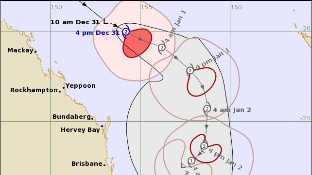
DANGEROUS surf, abnormally high tides and gale force winds will likely continue on the Gold Coast throughout Tuesday as Ex-Tropical Cyclone Seth lingers off the coast.
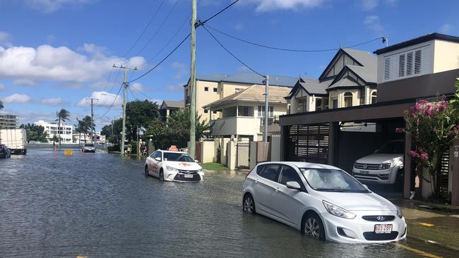
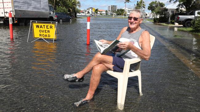
Monster waves have lashed the coastline and some city suburbs have been inundated by floodwater.
Surf Life Saving Queensland Gold Coast duty officer Brent Imrie said there had not been any rescues on city beaches as of midday Monday.
There had been about 500 “preventive actions” to stop beachgoers running into trouble statewide.
Mr Imrie praised the public for their co-operation, particularly holiday-makers disappointed they could not swim at the Coast’s famed beaches.
The Bureau of Meteorology (BOM) warned on Monday afternoon there was a “high degree of uncertainty around exact movements” of the weather system during the week.
It was not clear whether Seth will cross the Queensland coast, but it is expected to weaken.
The BOM has warned that a “large and powerful south-easterly swell” from the system would “coincide with tides around HAT (highest astronomical tide).
Forecasters have predicted shower and thunderstorm activity will ramp up midweek due to the presence of the system.
A king tide of two metres was predicted just before 8.30am on Monday and on Sunday night waves off up to seven metres were reported off the Coast.
All beaches were closed across the city as the system crept closer on Monday, according to Gold Coast City Council.
Early on Monday morning, Currumbin Vikings Surf Club receptionist Sam Dick said water had already risen into their car park.
“We have set the barricades up downstairs and got everything off of the floor in the pool room,” he said.
He said while they had contingencies in place they would continue to trade if the conditions deteriorated.
“We will continue on. People will be able to get through to the club for a fair bit of time and then we will make a track across the carpark,” Mr Dick said.
Currumbin Surf Clubs carpark was flooded by about 6.30am, reportedly sending kegs of beer into the ocean.
Water crept up to the bumpers of vehicles parked on the street at Budds Beach.
Budds Beach resident Bryan King said the community had been trying to talk to council about drainage problem in the area for 30 years.
“When we get a king tide, it goes up the storm water drains and back washes into the street,” he said.
“We have been discussing this with council for years and we came up with a solution years ago.”
He said relatively fresh councillor Darren Taylor was the only person who made it his mission to fix the problem.
“It’s only in the last six months the council have agreed to put one-way valves on storm water drains,” Mr King said.
“It should have been attended to by council 30 years ago.”
Mr King said Budds Beach usually floods three times a year – three times too many.
“It only lifts it ugly head when there are king tides, when it is too late,” he said.
“When there are cars parked in the street it gets into the brakes and if not the brakes, into the doors.
“It’s a very expensive operation for people staying in high rises or anyone in the community.
“The Mayor often makes comments whenever there is a weather event, that Budds Beach is going to flood.
“I mean they know its going to flood, why didn't they do something about it?”

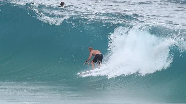
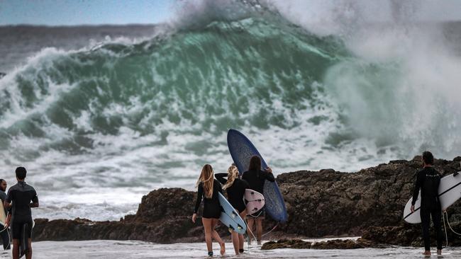
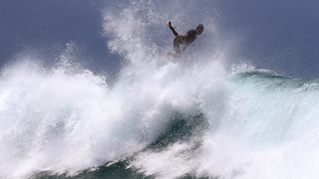
Surfers have been rushing to city beaches, despite mass closures, and some boardriders were seen being towed into huge waves at Burleigh, Currumbin and Kirra, with spectators watching on.
Queensland Police Service Commissioner Katarina Carroll said the number of people still venturing into the surf on the Coast when beaches were closed was extraordinary.
“It’s a severe weather system, with abnormally high tides and powerful and dangerous surf,” she said.
“I spent a couple of days down on the Gold Coast the past two or three days.
“The beaches are all closed and the amount of people still in the water was extraordinary. With surf life savers driving up and down the beaches telling people to get out.

“And as soon as they drove past people were getting back in the water.”
Commissioner Carroll said a Sunshine Coast dad, 49, had already died in the surf while trying to save his son from drowning.
“Can I please ask can you listen to authorities when they say the beaches are shut? They are shut.
“You are not only putting yourself in danger but our surf lifesavers.”
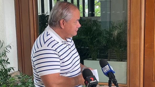
Gold Coast Mayor Tom Tate said the city would continue to watch and wait as Ex-Tropical Cyclone Seth weakened, but the system was still expected to pack a wallop.
The council’s disaster management team have been keeping an eye on flooding and the impact on city beaches, he said.

“We are prepared. The good news is that the system has weakened slightly from 48 hours ago. The beaches are being hit hard with large swells,” Cr Tate said.
“Our disaster management staff have just done a coastline inspection. The report is that scarping is occurring in places like Burleigh, Narrowneck and Main Beach.
“It is pointless trying to address that scarping now as any sand we locate there will be washed out to sea.
“Our role is to ensure safety of the beaches and visitors.”
Cr Tate warned gusts of up to 100km/h could occur this afternoon, continuing into tomorrow.
Ex-Tropical Cyclone Seth swell: 50+ photos, all beaches closed
Earlier: Gold Coast beaches remain closed on Monday, despite Cyclone Seth being downgraded to a subtropical low.
The system is expected to track west to north-westerly and approach the Queensland coast early this week.
“All Gold Coast beaches are closed today due to dangerous surf, a Gold Coast City Council statement read.
“Please listen to lifeguards and lifesavers, and stay out of the water.”

Nevertheless, surfers were expected to flock to the water again to take advantage of waves whipped up by the subtropical low.
On Monday morning, the Bureau of Meteorology (BOM) warned Ex-Tropical Cyclone Seth was in the southern Coral Sea and “generating seas and swells that are impacting exposed areas of the southeast coast”.
The BOM warned surf and swell conditions were “expected to be hazardous for coastal activities such as a rock fishing, boating and swimming”.
Forecasters expect hazardous conditions will continue through Monday as the low “drifts closer” to the coast before easing during Tuesday “as the system weakens”.
The BOM stated the hazardous surf conditions extend into northern New South Wales, including the Tweed.
A separate weather warning has also been issued for damaging wind gusts, which could reach 100km/h along the coast and ranges across southeast Queensland.
Additionally, the highest astronomical tide of the year is expected to impact the Coast and across southeast Queensland
Wave heights were predicted to reach four metres or higher on Monday.
Erosion has already occurred at city beaches and was expected to worsen in the wild weather.
The council has warned of “potential flooding in low-lying Gold Coast areas due to upcoming abnormal high tides”.
Monday is forecast to be partly cloudy, with a maximum temperature of 29C and a slight (30 per cent) chance of a shower, accompanied by southerly winds between 35-50 km/h.
Tuesday is also expected to be partly cloudy, with a temperature range of between 22-30C and winds ranging between 25-35 km/h.

There’s a medium (60 per cent) change of showers, and the city could be hit by a thunderstorm.
City sandbagging stations will be open from 6am-10am at 232 Old Pacific Hwy at Pimpama, 46 Boyd St at Bilinga and 61 Hutchinson St at Burleigh Heads.
Surf Life Saving Queensland has advised:
– People should consider staying out of the water and avoid walking near surf-exposed areas.
– Rock fishers should avoid coastal rock platforms exposed to the ocean and seek a safe location that is sheltered from the surf.
– Boaties planning to cross shallow water and ocean bars should consider changing or delaying their voyage.
– Boaties already on the water should carry the appropriate safety equipment and wear a lifejacket.
– Boaties should remember to log on with their local radio base and consider their safety management plan.
Cyclone Seth swell: Mayor issues warning
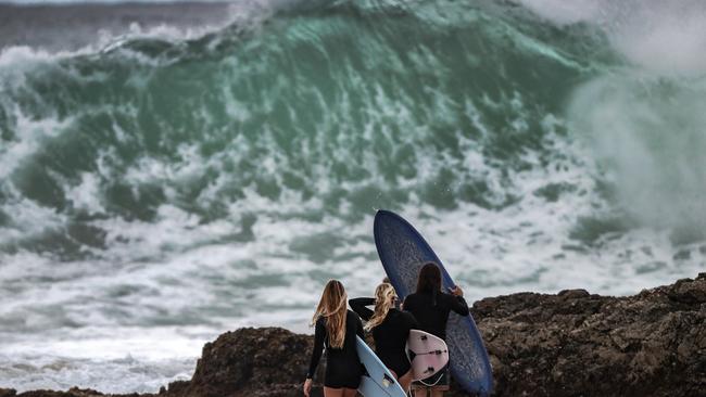
Sunday, January 3: The Gold Coast is on high alert for Cyclone Seth which is expected to hit in coming days, with hazardous surf reaching 3m.
Beaches across the Gold Coast are closed as dangerous surf fired up by the category one Cyclone batters the coastline.
All beaches from North Burleigh to The Spit are closed today with dangerous conditions in the water.
Some of the Gold Coast biggest names in surfing hit the huge swell off the beaches across the city on Sunday.
Former world champions Mick Fanning and Mark Occhilupo headed out to catch some waves at Snapper Rocks.
The category one cyclone was sitting 700km northeast of Brisbane on Sunday morning and the Bureau of Meteorology said it was expected to weaken to a subtropical cyclone throughout the coming days.
The weather bureau has issued a severe weather warning for abnormal high tides and dangerous surf affecting the Gold Coast, with an abnormal high tide expected Monday morning potentially bringing flooding to low-lying areas.
Metrologist Shane Kennedy said the surf could reach up to 3m across the next three days.
“The Gold Coast could see the deep water wave height getting up to 4m as well,” he said.
“The coastline is also at risk of some erosion.”
Mr Kennedy said the city would see high tides with the Gold Coast Seaway recording swells of just under 2m on Sunday morning.
“We would see some tides up to half a metre above the high tide level in coming days.
“Potentially, as the system gets closer, we could have a need for a severe weather warning for damaging wind gusts for exposed locations including the Gold Coast,” he said.
Mr Kennedy said the Gold Coast was expected to have light showers throughout the early days of the week, with a potential thunderstorm on Tuesday and Wednesday.
He said all weather conditions were dependent on where the Cyclone tracked.
Scarping is occurring on some Gold Coast beaches with more expected in coming days
Council has opened three sandbagging stations at Tugun, Reedy Creek and Pimpama.
More than 140 were picked up on Saturday afternoon from the council stations.
City on cyclone alert – Mayor suggests bowling and dining out
The Gold Coast is on high alert to see if Tropical Cyclone Seth will devastate our beaches after a barrage of wild weather inundated the city over New Year’s Eve.
Mayor Tom Tate said the city was keeping a close eye on evolving weather conditions as heavy rains and coastal swells started to impact the Gold Coast.
Beaches from Tallebudgera Creek to Southport were closed Saturday morning.
“We are doing some modelling today to see what impact tomorrow’s high-tide will have on low lying areas like Budds Beach,” the Mayor said.
“The high tide is due on Sunday morning and is predicted to be around .5 of a metre higher than normal high tides for this time of year.
“I advise everyone to keep their kids away from stormwater drains and local creeks such as Loders Creek and the main rivers feeding into our broadwater.
“So far, the beaches are holding up well and there is little scarping but we expect it to get worse over the next three days.”
The Mayor said coastal swells would build in the next 48 hours and the wind direction would play a significant part in how much erosion would occur.
He also asked families to take care when going to Gold Coast beaches, urging the public to follow all lifeguard directives and warnings.
“Please swim between the flags. Even if you’re a strong swimmer it’s nasty out there.”
Mayor Tate said “there are better activities to engage in” rather than go out in the wet weather.
“There’s wonderful restaurants open and there’s plenty of other things you can do.”
The Mayor even suggested “going bowling” was a better idea.
Tropical Cycle Seth originated in the Coral Sea, just northeast of Mackay on Friday, packing wind gusts up to 110km/h.
The storm has been downgraded to a category 1 but could intensify to a category 2 moving into Sunday.


Join the conversation

Body found at Gold Coast beach
A crime scene has been declared at a popular Gold Coast beach after a body was found early Saturday morning.
Read more

Southport to become the new Parramatta in suburb revamp
Southport is to be reimagined as the new Parramatta of Australia, with councillors headed on a trip down south to discover the suburb’s secret in becoming a thriving CBD.
Read more