
Redland to review massive bush clearing months after landmark court ruling
A Bayside council is investigating after a massive tract of bush on North Stradbroke Island was cleared just three months after a man was fined $20,000 for an unrelated clearing incident.


Logan
Don't miss out on the headlines from Logan. Followed categories will be added to My News.
A local council is investigating after a massive tract of bush on North Stradbroke Island was cleared late last month, three months after a court fined a man $20,000 for illegal clearing in an unrelated case on the island.
Residents of the island township of Amity lodged concerns about the land clearing after images emerged showing large tracts of exposed swamp where bush and large trees were felled in May.
Redland City Council said it was reviewing the clearing to determine if further action may be necessary.

The council said it had not received any reports of illegally cleared land at Amity in the period from May 13 to 30.
But residents, who did not want to be named, said the clearing had been reported after it had taken place two weeks ago at the end of Kindarra St, Amity.
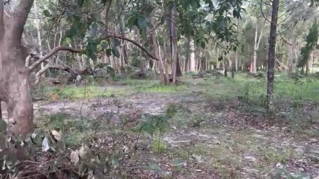
They said the bush had been cleared exposing large tracts of swampy land about 600m from the foreshore.
Residents said they were originally told the land was being cleared for private purposes before they were later told it was to be part of a fire break behind the township.
Native title maps of the area show the cleared land as “conservation zone” or “recreation and open space” zone.

In a statement about the clearing, Redland city Council said: “Council notes that some land in this area is owned by the Queensland Government and some is subject to the Queensland Government’s Temporary Local Planning Instrument – the Quandamooka Land Aspirations Area (TLPI No. 1 of 2023).”
The state government was contacted for comment about the land clearing.
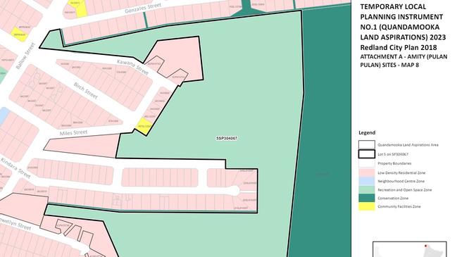
In September, Queensland’s then Deputy Premier Steven Miles introduced a planning measure to suspend and alter the operation of Redland City Council’s town plan over parcels of land on the island.
The move effectively means the usual council regulations and guidelines outlined in the Redland City Plan would be overridden on the specified parcels of land, known as the Quandamooka Land Aspirations Areas.
In an entirely separate incident in February, Brisbane Magistrate Ross Mack found Quandamooka man Darren Burns guilty of illegally clearing land at East Coast Rd, Point Lookout on North Stradbroke Island/Minjerribah in 2020.
It is not suggested that Mr Burns is linked to recent land clearing at Amity.

A second charge of carrying out an assessable development without a permit was dismissed.
The court fined Mr Burns $20,000 plus costs and ordered him to revegetate the land.
According to a public statement by council, Magistrate Mack also found that the state government planning laws were applicable to the land and the clearing of native vegetation, carried out by Mr Burns, contravened section 162 of the State Planning Act, which is a development offence.
The court did not accept the defence that being a native title holder, Mr Burns was exempt from State Government Planning Laws and Council’s Planning scheme, the council statement said.
The court also acknowledged the clearing of native vegetation, in this instance, was not consistent with a traditional customary practice.
More Coverage


Originally published as Redland to review massive bush clearing months after landmark court ruling
Join the conversation

‘Boobie brigade’ raises $1.7m for breast cancer
Not even Cyclone Alfred could stop Queenslanders, who turned streets pink and raised $1.7m for breast cancer research and care, proving resilience has weathered the storm.
Read more
Seen this car? Cops’ new lead in alleged kidnapping, torture murder case
Detectives have released an image of a vehicle they believe could assist with investigations into the alleged kidnapping, torture and murder of a 52-year-old South East Queensland father in January.
Read more