
City targets west and northern hinterlands suburbs for fire hazard burns as fuel load increases
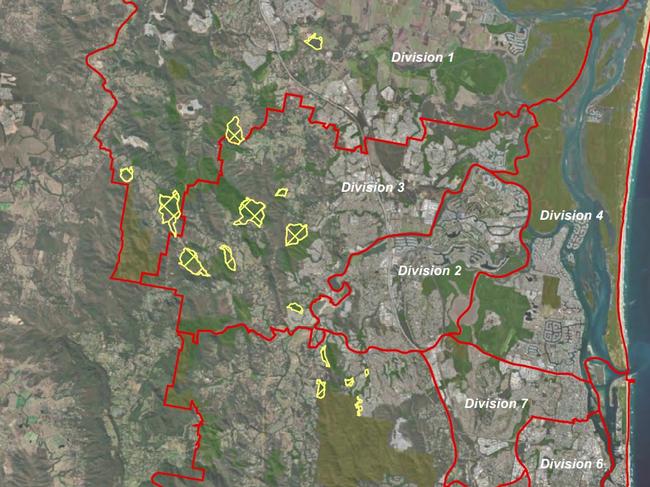
Fourteen Gold Coast areas are being targeted for hazard reduction burns amid fears more than 40,000 homes could be at risk. See the full list of areas impacted.

Gold Coast
Don't miss out on the headlines from Gold Coast. Followed categories will be added to My News.
The Gold Coast’s western and northern hinterland suburbs are being targeted for hazard reduction burns with the City closely monitoring increased fuel loads after rain events.
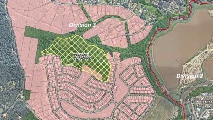
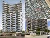
Some of the controlled burns planned will include parklands around fast growing suburbs like Upper Coomera.
A report two years ago first warned the Coast has a “considerable residual bushfire risk” and there would be days — during extended dry periods — when fires were uncontrollable across the city.
Planning maps showed at least three quarters of the city is exposed to some fire risk.
Since 2019 at least 42,000 structures were regarded as being exposed to a fire threat with 51,051ha, or 37 per cent of the Coast’s total area being mapped as “very high, high or medium bushfire hazard”.
Councillors at a lifestyle committee meeting on Thursday were briefed on the City’s current safety burn program for bushland which will continue until the end of the year.
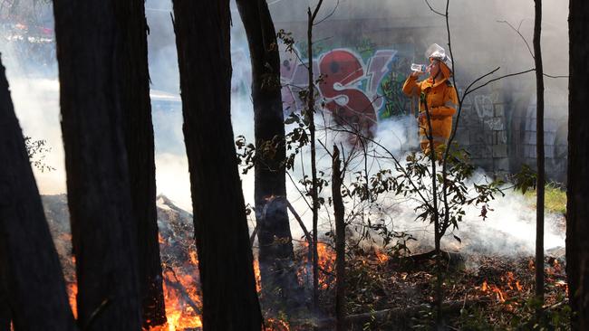
City officers say residents who have respiratory and other health issues are on a priority list and notified of the burning program days before it occurs.
Lifestyle committee chair Glenn Tozer said he had received community feedback about concerns on increasing fuel loads after the city greened up after Tropical Cyclone Alfred and rain events which followed.
An officer told the committee: “In general, we are overseeing what the fuel load is like in conservation areas. We are constantly monitoring.”
Mr Tozer, who is based in a hinterland division, said: “During the really heavy rain a lot of fire trails were eroded – the fire trails almost work as a drainage route as well. They’ve been quite impacted.”
Officers said rangers and staffers were conducting an audit of fire trails to ensure they were open for emergency vehicles.
Mr Tozer asked officers about future special budget discussions, where funding may need to be increased for more burns.

Officers believed there was room in existing budget funding for this year to cover extra costs.
The City in 2024 conducted burns in 19 sites and had to notify almost 4500 residents about potential smoke hazards.
Areas targeted like Pleasant Parklands in Upper Coomera are surrounded by housing estates.
“We are making sure we are doing everything we can to make the city safe as we head into the next bushfire season,” Mr Tozer told The Bulletin.
Disaster managers said the 2025 Hazard Reduction Burn Program, which started in March, would continue until the end of the year “subject to suitable conditions”.
Fourteen sites have been nominated with the focus in the north on Cedar Creek, Pimpama, Kingsholme Wongawallan and Upper Coomera,
Further south, the suburbs targeted include Maudsland, Pacific Pines, Mudgeeraba, Reedy Creek and Springbrook.
“The timing of each hazard reduction burn is dependent on a number of factors, such as vegetation types, topography, burn objectives, potential smoke impacts and weather conditions,” managers said.
All burn sites are continuously monitored throughout the season to identify when conditions might be favourable for a particular site. Wet weather had delayed some burns.
“Due to the dynamic nature of the weather, the decision to burn can often only be made a few days prior, however, we will endeavour to notify (the public) as soon as it is possible to do so,” disaster managers said.
In 2019 fires raged across the hinterland, continuing for a week at Canungra in what firefighters described as “catastrophic conditions”.
THE 14 LOCATIONS PINPOINTED BY COUNCIL
Below are the 14 burns which are proposed for the Hazard Reduction Burn Program 2025. The breakdown is for suburb, the council division and amount of hectares for the “burn area”.
* Upper Ormeau Conservation Area - Kingsholme - Division 1 - 57.7.
* Wongawallan Conservation Area Kingsholme Section - Kingsholme - Division 1 - 91.9.
* Timberview Reserve Eastern Section - Wongawallan - Division 3 - 62.0.
* Crystal Creek Reserve - Willow Vale - Division 3 - 17.0.
* Gladrose Reserve - Wongawallan - Division 3 - 18.7.
* Caballo Road Reserve - Guanaba - Division 5 - 46.0
* Lower Beechmont Conservation Area - Clagiraba - Division 5 - 65.4.
* King Parrot Reserve - Guanaba - Division 5 - 26.1.
* King Parrot Reserve (Southern Section) - Clagiraba - Division 9 - 16.2.
* Austinville Conservation Area Mudgeeraba Creek Section - Austinville - Division 9 - 107.7. * Bonogin Conservation Area (Smith Street) - Bonogin - Division 9 - 89.7.
* Numinbah Conservation Area Numinbah Valley - Division 9 - 14.4.
* Bally Mountain Conservation Area Rosegum Section - Bonogin - Division 9 - 94.5.
* Bonogin Conservation Area Telstra Track Northern Section - Bonogin - Division 9 - 25.4.

‘Appalled’: Bush turkey dies after being struck by arrow
A bush turkey has sadly died after being struck by an arrow in a sickening attack on the Gold Coast.

Road rage incident ends with bat through car window
The passenger of a car involved in a road rage incident has been sentenced after he took a baseball bat to a vehicle that had two children inside. Read what happened here.