
Climate change: Gold Coast suburbs at risk of being washed away as sea levels rise
Most of the our iconic beaches and tourism hotspots could be washed away unless swift action is taken. LIST OF SUBURBS AT RISK >>>
Central
Don't miss out on the headlines from Central. Followed categories will be added to My News.
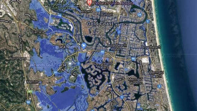
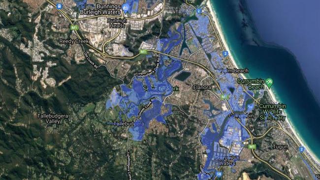
MOST of the Gold Coast’s pristine coastline, iconic beaches and tourism hotspots face being washed away unless swift action is taken on climate change, new mapping shows.
Bond University environmental science expert Daryl McPhee said the new data had used a “worst case scenario” approach, indicating by year 2100 global sea levels could have increased by 0.84m.
The alarming map shows vast swathes of the Glitter Strip under water, including parts of Biggera Waters, Labrador, Paradise Point, Runaway Bay, Coomera, Carrara, Palm Beach, Currumbin and Tweed Heads.

Large sandy stretches of iconic beaches could also be washed away, including Burleigh Heads, Byron Bay, Agnes aater, Noosa and Whitehaven.
The Coastal Risk Australia interactive web mapping is based on the latest scientific modelling to show how rising sea levels are potentially predicted to impact communities.
It is based on a new climate change report from the Intergovernmental Panel on Climate Change, incorporating significant advancements in modelling the behaviour of ocean ice sheets.
Dr McPhee said low-lying areas and those around the Nerang River were most at risk of being inundated.
These include Clear Island Waters, Bundall and Coombabah.
“If you have a waterfront property, expect water to be in your loungeroom in the future – according to this mapping,” he said.
“It’s a long-term issue for the property market.
“There could be changes in lending patterns from banks for low-lying areas at risk of inundation during the life of a home loan.”
But Dr McPhee urged property owners to take into account the “pessimistic” nature of the modelling, adding “no one should be selling up tomorrow because of these maps”.
He said the city needed to ensure the Coast’s A-line sea wall continued to be protected and for development planning to take into account climate change and rising sea levels.
FrontierSI and NGIS Australia developed the Coastal Risk Australia tool which provides the mapping.
“The advances in science confirmed in the IPCC Sixth Assessment report show that sea levels will continue to rise for future generations, impacting on Australia’s coastal infrastructure,” NGIS Australia executive director Nathan Eaton said.
“We wanted to communicate how the new projections would impact Australian coastal communities.
“By 2050, sea level change of 15 to 30cm will be unavoidable, this means that coastal flooding will become worse during storm surges.
“Scenarios beyond 2050, however, become increasingly sensitive to choices and actions made by global communities to reduce emissions.”
More Coverage


‘Really good bloke’: Well-known Gold Coast real estate agent dies
A long-time Gold Coast real estate agent is being remembered as a “really good bloke” who was “a lot of fun to be around”. READ THE TRIBUTES

State’s busiest ED boosts capacity amid rise in life-threatening cases
Gold Coast University Hospital is taking action to address a growing challenge in its emergency department.