
How the trams will change the size of your suburb under new council planning maps
THE Gold Coast’s own light rail is changing the look of the city’s suburbs as it moves further south — impacting and even overriding density planning for the area.

Council
Don't miss out on the headlines from Council. Followed categories will be added to My News.
SPECIAL light rail mapping used by the council is showing how low-density suburbs along the tram corridor can be rapidly transformed into high-rise.
A “light rail urban renewal map” was a key factor in the city council’s planning committee approving a Main Beach beachfront tower in a medium-density area this week.
Planning officers noted “the Main Beach light rail station was approximately 750m walk to the southwest of the (development) site” — effectively setting a distance on the tram line’s wider impact on development applications. As the mapping is developed, councillors and protesting residents are predicting a similar outcome for Burleigh and Palm Beach as the light rail route is extended south to the Gold Coast Airport.
COAST SKYLINE DEBATE: HOW MAIN BEACH IS ABOUT TO BE TRANSFORMED
The decision has sparked a political war, with Main Beach unit owner and leading Sydney radio host Ray Hadley yesterday targeting council planning chairman Cameron Caldwell.
“Cameron, you have abrogated your responsibility to the residents of Main Beach — I hope you pay a significant penalty at the next election,” Hadley said.
“It’s simply a disgrace that the eastern side of Main Beach Parade is not being protected. If this is your legacy, it’s a shocking one.”
COUNCIL APPROVES CONTROVERSIAL MAIN BEACH TOWER
Cr Caldwell replied that community expected the City Plan to be followed, the approval was compliant and “personal attacks on councillors are not helpful in dealing with community concern”.
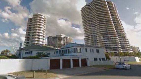
Councillors at a full meeting on Tuesday are expected to back the committee’s decision to approve the 20-storey tower by developer Hapsburg on a slender 1261 sqm block in Main Beach Parade.
NEVER MISS A MINUTE WITH THE GOLD COAST BULLETIN APP
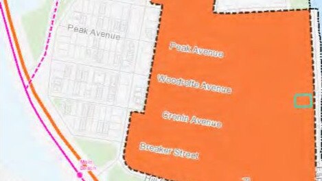
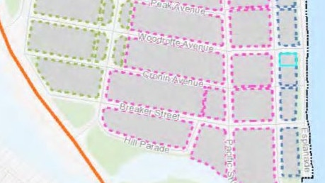
The council officer planning report included a density overlay map that shows the section of the exclusive suburb between the Southport Surf Life Saving Club and Narrowneck caters for one bedroom per 33 sqm.
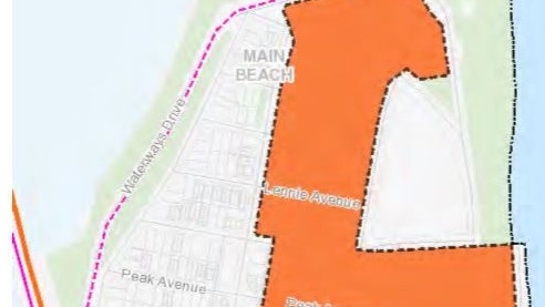
The light rail overlay section covers the existing apartment block area closest to the beach, excluding homes between Waterways Drive and Tedder Ave, but residents fear that could change if amendments are made to the City Plan.
Main Beach has many high-rise towers but it is renowned for those apartment blocks being built on larger sites to accommodate ground-floor pools and landscaped gardens.
The report also included a light rail overlay map covering the same 11 street blocks, which ultimately saw a majority of councillors support more than tripling the density under the City Plan for the beachfront site.
SUBSCRIBE TO THE BULLETIN AND GET A FITBIT
Outside the meeting, Cr Caldwell was asked if light rail played a major factor.
“Yes, because it’s situated in the light rail frame area,’’ he said. “So that light rail frame area almost overrides that density provision. It’s a more higher level of importance, if you like.”
The planning chairman backed Robina-based councillor Hermann Vorster, who argued the importance of increasing the city’s development focus east of the M1.
“We can’t keep pushing the urban fringe of our city out and out, we’ll end up eating all of our green space,” Cr Caldwell said.
“We can’t service it with infrastructure so we need to turn our focus to the centre of the city and make sure we are developing in places that can handle the population, which are also places people want to live.
“Beachfront apartments have a long history on the Gold Coast of being a great place to live.”
Main Beach Association spokesman David Hutley warned southern residents along the planned light rail route.
“The council took more notice of light rail than the density zoning. That could impact for the people down south, all the way down. For those suburbs it will be a real problem,” he said.
Bemused MP’s slapdown for council on parking fines
A Gold Coast MP has questioned why council is writing to the state to get parking rules relaxed – claiming legislation not only allows them to do so, but councils including Logan already take advantage. Watch the video of how Logan do it.

‘Shoe print on his head’: Family of teen bashing victim speak out
An evening walk to grab an ice cream took a shocking turn for a couple of Gold Coast teens, allegedly brutally bashed in a gang attack and left with shocking injuries. Now their parents have revealed the devastating toll.