
Blood red map: where animals are killed on Gold Coast roads
New mapping has revealed where kangaroos and koalas are being hit by cars most often on the Gold Coast. SEE OUR LIST OF THE WORST ROADS

Council
Don't miss out on the headlines from Council. Followed categories will be added to My News.
NEW mapping shows the Gold Coast is the horror hot spot for road deaths of native animals in south-east Queensland.
A report to council reveals that between 2017 and 2019 more than 3000 native animals in the city were struck by a vehicle.
Wildcare Australia Inc and the Currumbin Wildlife Hospital provided the data on kangaroos, koalas, possums, snakes, turtles, bats, pademelons, bandicoots, frogs, gliders, lizards and echidnas.
A map shows koala kills are worse in the south, around the Currumbin Valley, while most kangaroo fatalities occur just further north west of the Pacific Motorway.
The Glitter Strip suburbs close to the beaches record only a handful of animal fatalities.
Hinterland councillor Peter Young, an environmentalist, apologised for becoming emotional in an address to the planning committee today, explaining he had just spoken to a traumatised family.
“On the way here there was an incident with a koala taken away which died on its way to Currumbin wildlife hospital,” he said.

“I think there is a real sense of urgency about this kind of stuff. We got clear evidence that in three years there were 3000 recorded cases for the species mentioned. That’s nowhere near where the real total probably is — it must be many times that.”
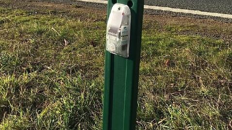
Cr Young received unanimous support from colleagues about backing a report which could fast forward a trial on new virtual tracking technology which involves signals and sounds being sent out to warn off animals from roads.
He said he was also concerned about accidents involving feral animals like deer in Nerang.
“These are big animals. They cause huge impacts and damage to vehicles. There’s probably been loss of life with some of those incidents,” he said.
“I think that we are in the hot spot of south-east Queensand. We live in this incredibly biodiverse city and it’s incumbent upon us to do the very best we can for these creatures who can’t defend themselves, speak for themselves.”
The highest clusters of kangaroo and wallaby vehicle strikes occurred at:
• Pine Ridge Road, Coombabah and Runaway Bay
• Currumbin Creek Road, Currumbin Valley (State controlled)
• Brisbane Road (Gold Coast Highway), Arundel and Coombabah (State controlled)
• Napper Road, Arundel and Parkwood
• Helensvale Road, Helensvale
• Simpsons Road, Elanora/Currumbin Waters
• Pacific Pines Boulevard, Pacific Pines

For koala vehicle strike data, the roads which were the worst included:
• Pacific Motorway, Burleigh Heads-Pimpama-Coomera (State controlled)
• Brisbane Road (Gold Coast Highway), Helensvale-Arundel-Coombabah (State controlled)
• Tallebudgera Connection Road, Currumbin Valley-Tallebudgera (State controlled)
• Smith Street, Molendinar-Parkwood-Southport (State controlled)
• Guineas Creek Road, Elanora-Tallebudgera
• Galleon Way, Currumbin Waters
• Captain Cook Drive, Arundel
• Simpsons Road, Elanora-Currumbin Waters
• Napper Road, Parkwood-Arundel
• Oxley Drive, Runaway Bay (State controlled).
MORE NEWS
‘Give us a date Premier’: Tourism boss makes plea on border
Police charge three men after marina blaze
Major breakthrough for Ashmore Plaza retailers
The council has introduced fauna exclusion fencing and underpasses, static wildlife signage, koala speed awareness devices and community education and awareness messaging.
Vehicle warning systems for wildlife is an emerging technology used in Tasmania and Victoria, with several other Queensland councils trialling it.
Virtual fencing costs about $8400 per kilometre based on 40 units per kilometre.
Depending the finding of the council report, the trial could start in 2020-21.

Poop ponderings: How will city dispose of cableway visitors’ waste?
The Springbrook cableway project could attract 580,000 visitors annually, but the problem of what to do with all their waste has raised its head.

Millionaire’s Row vs Cane Fields: Gold Coast’s bitter housing divide
The Gold Coast’s biggest development fight is where to fit one million people. The choices made will have lasting consequences, writes Paul Weston.