
Cat 2 Tropical Cyclone Errol intensifying off the northwest Kimberley coast
The Category 2 cyclone is expected to intensify through the day, and could make landfall later this week. See the latest update.

News
Don't miss out on the headlines from News. Followed categories will be added to My News.
Tropical Cyclone Errol is intensifying off the northwest Western Australia coast with the Bureau of Meteorology warning residents in the Kimberley to stay alert as the weather system moves towards the mainland.
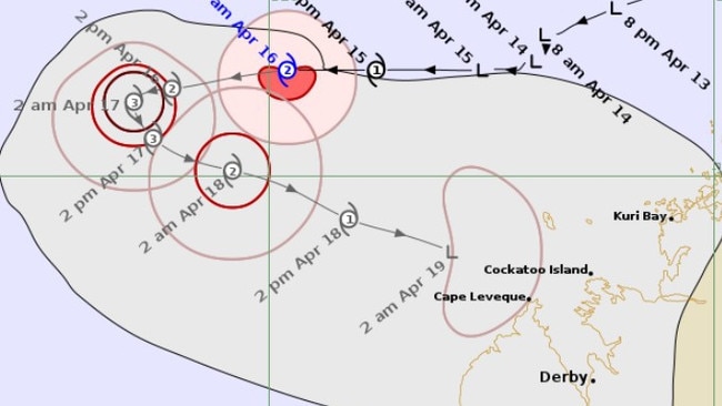
As of early Wednesday morning, Errol was a Category 2 cyclone, sitting 510km north of Broome.
Sustained winds near the centre of the storm are at 95km per hour, with wind gusts reaching has high as 130km per hour.
Errol is moving west, and is expected to intensify through Wednesday, becoming a Category 3 that night.
The Bureau forecasts that the cyclone will weaken as it moves towards the mainland, becoming a Category 1 on Friday, and petering out back to Tropical Low in the early hours of Saturday.
“From Thursday Errol is expected to turn southeast towards the coast and peak in intensity as a severe tropical cyclone,” the Bureau said in a statement.
“By Friday Errol should weaken as it approaches the west Kimberley coast.”
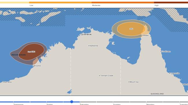
Meanwhile Tropical Low 30U off the Northern Territory coast continue to lie over the northeastern Arafura Sea.
From Thursday or Friday the system may move to the east or southeast.
There is a low chance (15 per cent) it could develop into a tropical cyclone from Wednesday through to Sunday, if it remains over the water.
“There is considerable uncertainty in both the track and development, so communities in the region should stay up to date with the latest forecasts,” the Bureau said.
More Coverage
Originally published as Cat 2 Tropical Cyclone Errol intensifying off the northwest Kimberley coast

Unbeaten Palmerston to take on Sharks test in NRL NT Round 3
Strong inclusions have helped the Palmerston Raiders to the perfect start to the season, but they will be put to the test against a Sharks outfit eager for a first win. Catch up on the latest NRL NT action.
Lest we forget: Alice Springs gives standing ovation to those who served
Alice Springs has delivered a standing ovation for armed service members past and present, as veterans share what Anzac Day means to them. See the pictures.