
Far North southern region hit with heavy rain and damaging winds
The North Queensland strike zone has narrowed after Tropical Cyclone Kirrily officially formed overnight, with southern areas of the Far North preparing for strong gales and heavy rain.
Cairns
Don't miss out on the headlines from Cairns. Followed categories will be added to My News.
The North Queensland strike zone has narrowed after Tropical Cyclone Kirrily officially formed overnight, with southern areas of the Far North preparing for strong gales and heavy rain.
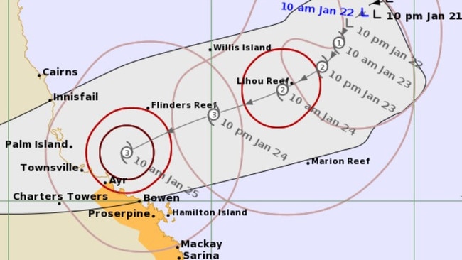
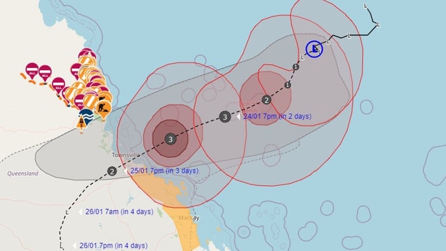
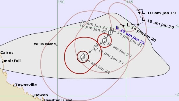
TC Kirrily, officially named overnight, will likely hit the coast between Ingham and Bowen, most likely near Townsville, on Thursday night as a category 2 system and will bring gale force winds and heavy rain to areas between Innisfail and Ayr from this afternoon, according to the Bureau of Meteorology.
Damaging winds of up to 120km/h are expected to reach up to Innisfail from the cyclone’s impact point into this evening while gales with damaging winds of up to 90km/h are forecast to extend inland to Charters Towers overnight and into Friday.
Heavy rain, potentially leading to flash flooding, is likely to affect areas between Innisfail and Sarina this morning before moving inland later today.
As TC Kirrily crosses onto land, heavy rain is possible across the Far North with showers developing for the Cairns, Mareeba and Atherton regions and possible showers for areas around Port Douglas.
WHAT IT MEANS FOR THE FAR NORTH
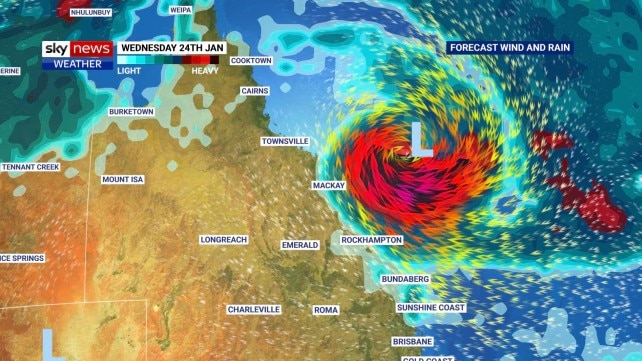
Tropical Cyclone Kirrily will bring thunderstorms, a heatwave and damaging winds to large parts of the Far North coast this weekend, as Townsville stares down the barrel of a direct hit.
The Bureau of Meteorology now predict tropical low 05U will cross the Queensland coast as a category 2 tropical cyclone rather than a category 3 system which is expected to impact much of the weekend weather across the state.
BOM Meteorologist Adam Blazak said the downgrade would cause the cyclone to “take a new path”.
“We were expecting the tropical low to go inland and turn back towards South East Queensland,” Mr Blazak said.
“Now the modelling has it moving inland and staying inland around Georgetown and Cloncurry area.”
Mr Blazak added the weather system would draw in winds from the coast, potentially bringing rain and thunderstorms from Cooktown to Innisfail over the weekend.
“Currently, the Cairns forecast has zero to two millimetres of rain predicted – I would keep an eye on that,” he said.
“I wouldn’t be surprised if those forecast change between now and the weekend and we start seeing larger totals between 20 to 40mm of rain over the weekend.”
The meteorologist also warned the region would experience an extended heatwave through to Monday due to the tropical low’s position.
“Not only will those winds bring in storms from the northwest, they’ll also bring in hot weather,” he said.
“We’ll likely see hot day time conditions and very warm night time conditions as well.”
While thunderstorms were a possibility, Mr Blazak said it would not impact the region as severely as recent rains.
“The storms should be fairly fast-moving which should keep rain totals down a bit, but it will be quite heavy rainfall,” he said.
“But it is nothing out of the ordinary for the region.”
As the cyclone crosses on Thursday, heavy rain is predicted for south of Innisfail; destructive winds of up to 140km/h may develop from Cardwell to Proserpine and damaging winds of up to 90km/h are predicted for Lucinda to Innisfail and inland to Charters Towers.
“From Thursday night and into Friday there will be westerly winds from the cyclone coming down from the escarpment and causing damage,” Mr Blazak said.
He warned the wider Cairns region may also experience damaging winds throughout the weekend.
“The other time you may see damaging wind gusts is in the afternoon accompanying the thunderstorms on Friday, Saturday and Sunday,” he said.
“These could be large enough to bring down tree branches and even bring small trees over.”
EARLIER
A tropical low is now predicted to reach the Queensland coast as a category 2 system, bringing damaging and destructive winds to parts of the Far North from Thursday.
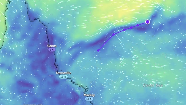
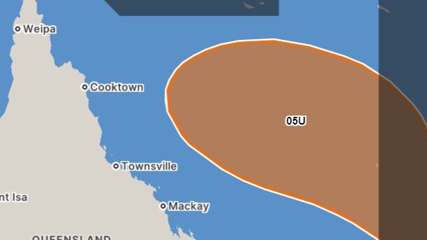
The Bureau of Meteorology has predicted tropical low 05U, 590km northeast of Mackay on Wednesday morning, will hit the coast as a category 2 cyclone on Thursday night between Cardwell and Bowen.
The tropical low is expected to reach cyclone status later tonight and is no longer predicted to reach severe tropical cyclone level (category 3).
Damaging winds of up to 120km/h are forecast from Ayr to Sarina along the coast from Thursday while winds of 90km/h could still be felt from Lucinda to Innisfail if the cyclone where to track north during this time.
Destructive winds of up to 140km/h may reach up to Cardwell and down to Proserpine during Thursday.
Innisfail to Sarina will most likely receive heavy rainfall potentially leading to flash flooding from early Thursday morning before spreading inland from late Thursday, as predicted by the BOM.
A warning zone between Lucinda and Sarina has been established by the BOM while Innisfail to Sarina is still being considered a watch zone by the organisation.
EARLIER
Tuesday’s advice from the Bureau of Meteorology showed the slow moving tropical low 05U around 840km east north east of Townsville with development into a tropical cyclone, to be named Cyclone Kirrily, predicted for Tuesday night or during Wednesday.
It is set to hit the Queensland coast between Cardwell and Airlie Beach overnight on Thursday.
While the chance of a severe tropical cyclone on landfall remains, it has decreased overnight as the system slowly moves towards the coast.
“[The decreased chance] is due to the slower development of the system into a tropical cyclone,” a Bureau spokesperson said.
“A slower development is likely to mean a lower intensity.
“It’s hard to quantify the exact probability number in terms of percentages [of the decreased chance] but if the system was to develop into a tropical cyclone overnight Tuesday and maintain a slower approach to the coast, then this would increase its chances of reaching a severe tropical cyclone on landfall,” the spokesperson said.
The Bureau warned damaging winds of up to 120km/h could reach up to Cairns on Thursday and destructive winds of up to 150km/h could develop across the coast between Cardwell and Bowen in the same time period.
Heavy rainfall leading to flash flooding is predicted for the Far North to Cairns during Thursday and Friday.
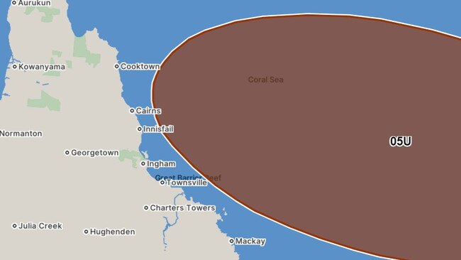
Cairns remains outside of the potential cyclone strike zone which currently extends from just below Cairns to St Lawrence.
EARLIER
On Monday, a new area spanning 400km was identified as a watch zone by the Bureau of Meteorology as the slow moving 05U tropical low intensified and lined up a coastal strike area between Innisfail and Bowen.
At 7am on Monday the system, expected to be named Cyclone Kirrily on Tuesday, was sitting 800km north west of Cairns and was forecast to start moving to the southwest later on Monday, towards the Queensland coast.
“A severe impact is likely, particularly if the system crosses near or south of Townsville,” the update states.
If the cyclone were to cross the coast, it was then expected to weaken to a tropical low and move further south over land.
Cairns-based Bureau community information officer Daniel Hayes said forecast models were beginning to align in terms of where the system would cross the coast.
“The storm is starting to get going,” he said.
“The modelling seems to be lining up, we did see a lot of variation the last few days in terms of the track.
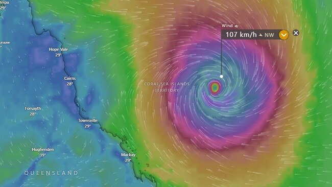
“We are talking about 120-160km/h winds and gusts of up to 220km/h, we are talking destructive wind gusts.
“And we are looking at heavy rainfall and flash flooding and even in those areas away from the coast and we could get quite significant impacts across large parts of the state.”
There has been little variance between the latest track map issued at 12pm and the earlier 9am update.
And the Bureau’s newest information has a category 3 system hitting midway between Ayr and Townsville.
Mr Hayes said a storm tide was possible from St Lawrence to Ayr and the storm tide would be more pronounced on the southern flank of the system.
“We will probably see the bulk of the rainfall in that south flank and that’s where we will see the biggest storm surge impact,” he said.
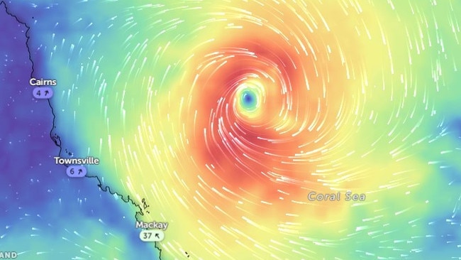
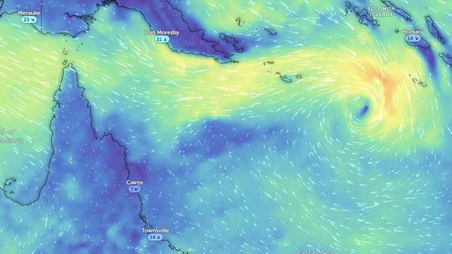
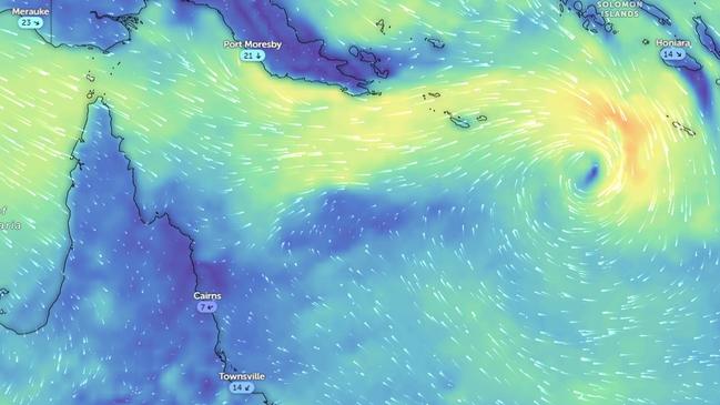
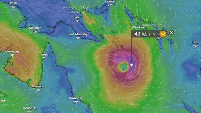
Tropical low's 03U and 05U swirlling over WA and the Coral sea respectively this morning. #CycloneKirrilypic.twitter.com/39dexaeGzb
— James Holbeach⛈🌪 (@opplevelse) January 22, 2024
In terms of impacts to Cairns and the Cassowary Coast Mr Hayes said saturated catchments throughout the Far North meant not much more rain was needed to make an impact.
“We have minor flooding of the Tully and Daintree and the catchments in the north are quite saturated and we are hoping for southerly crossing,” he said.
“There is some potential for some downslope winds and as the wind comes in they come back down the slopes so there’s potential for damaging winds around the Cairns area.
“We could see some enhancement of the winds up this way.”
Downslope wind or katabatic wind are a drainage airstream that carries high-density air from a higher elevation down a slope under the force of gravity.
Communities on the east coast of Queensland are advised to stay up to date with forecasts and warnings.
SUNDAY
The Bureau of Meteorology has issued a warning that a Coral Sea tropical low will likely form into a cyclone late Monday or early Tuesday and is “most likely” to cross the coast between Cairns and Mackay in the middle of the week.
A senior forecaster at BOM said there’s a “high probability” the tropical low will become a category 3 or 4 cyclone.
The 05U system is forecast to begin to move to the southwest late Monday, towards the Queensland coast.
BOM says a coastal crossing is likely around the middle of the week, with the most likely zone between Cairns and Mackay.
BOM Senior Forecaster Steve Hadley said there is a “high probability” that the tropical low will become a category 1 cyclone by tomorrow afternoon, possibly even as early as tomorrow morning.
“I would say it is likely that it will become a category 3 cyclone with a possibility it may become a category 4” Mr Hadley told Newscorp.
Mr Hadley explained that the longer the system is out in the ocean the more it will be able to increase its winds.
Within 72 hours I expect the system to become a category 3” Mr Hadley said.
He said the cyclone will hit the coast somewhere between Cairns and Mackay in the middle of the week.
Mr Hadley said the system is moving faster than the last time it crossed the coast.
“A severe impact is possible, particularly if the system crosses near or south of Townsville,” the latest Bureau update stated.
“If the cyclone were to cross the coast, it is then expected to weaken to a tropical low and move further south over land.
“This would bring heavy rainfall to areas well south of the crossing zone late in the week or over the weekend.”
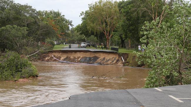
Minor flood warnings have been issued for the Daintree and initial minor flood warning Barron River after more than 2000mm fell during record-breaking floods in the days after Tropical Cyclone Jasper crossed the coast in December.
“Communities on the east coast of Queensland are advised to stay up to date with forecasts and warnings” BOM says.
Mr Hadley said heavy rainfall was the main concern, particularly as the impacts would likely hit on Friday when people began travelling for the Australia Day long weekend.
Rainfall has the potential to last into the following week, with flash flooding likely in some areas.
“It’s too early to tell exactly how much rainfall and where it comes along,” Mr Hadley said. “People really need to keep an eye on the forecast, not just those in the crossing zone, but all areas south of Mackay as well.”
In the 24 hours to 9am Sunday, rainfall totals of up to 60mm have been recorded in the Daintree and Mossman River catchments.
Further showers are possible over the next few days, however further flooding is not expected. On Sunday flooding had eased along the Daintree River with river levels falling below the minor flood level at Daintree Village.
When the system does reach cyclone intensity it will be named Kirrily.
FRIDAY
A minor flood warning was issued for Kamerunga Bridge at 5am Friday, while minor flooding occurred at Daintree Village around 9.30pm on Thursday.
Meteorologist Daniel Hayes said rainfall in the Far North was part of the monsoonal trough moving through the area, but urged people to stay alert and up to date with flood and weather warnings.
“It’s something to be alert about. The catchment is very wet so when we get big falls the catchment fills up quickly. We’re not expecting to see continuing heavy rainfall, mostly showers through the monsoon trough,” Mr Hayes said.
“There will have the potential for those showers to band but where it is from a day-to-day basis and is likely to be along different places down the coast. If we get a couple days with rainfall in the same area, we could see (flood) responses in those areas. Definitely something to keep an eye on.”
Despite the heavy rain on Thursday night, Mr Hayes said Cairns only recorded between 35mm to 50mm between the airport and the racecourse.
“For the most part, we’re looking at 50mm to 100mm,” he said.
Mr Hayes urged residents to prepare themselves again, in case another cyclone hit the Queensland coastline.
“The system strengthened a little overnight, but is still the weakest of the systems we have. Initially it’s going to be fairly slow moving. From Sunday, it looks like it will start to move on a south or south westerly track. The issue is that we have competing upper air influences that will act to bring it towards the coast or bring it away,” he said.
“There’s still a bit of divergence from the modelling. So unfortunately there’s still a fair bit of uncertainty right along the coast. It’s definitely something people need to keep track of. If you’ve got any prep to do, do it now.”
DISASTER GROUP ON ALERT
Cairns’ Local Disaster Management Group held an extraordinary meeting on Thursday in preparation for a second cyclone to hit the region just six weeks after ex-Tropical Cyclone Jasper.
Cairns Regional Council has made preparations to activate places of refuge in case tropical low 05U – which has an 85 per cent chance of reaching cyclone strength next week, according to BOM predictions – crosses the Far North coast.
According to the BoM’s tropical cyclone forecast, 05U will kiss the coastline as early as Wednesday morning.
“As standard procedure, preparations have been made should the Public Storm Tide Cyclone Shelters be required to open, and the Disaster Management unit is also prepared to activate Places of Refuge, should they be needed,” council’s CEO Mica Martin said.
“Flooding associated with Jasper was unprecedented after it stalled over the Cape York Peninsular, causing an extended period of severe rainfall.
“While there was significant riverine flooding in the Barron delta, the resilience of the city’s Council-controlled assets was evident with most local roads as well as drainage, water and sewage infrastructure able to manage the deluge.
“Access has now been restored to most areas, although there are some areas where long-term solutions will need to be determined.”
Ms Martin said the council held concerns for the areas hit hardest by catastrophic flooding that followed Jasper, particularly the Northern Beaches suburbs.
“Residents should also be aware that as the ground is already saturated, there is an increased risk of landslips and trees falling,” she said.
Nathan Lee Long, a civil infrastructure team leader at Jacobs, said identifying infrastructure at risk of further and greater impact was a priority.
“Where you have landslides that have not been rectified, potential for those to fall to a greater extent is pretty high if you add more rain,” Mr Lee Long said.
“Look at drainage channels to ensure blockages are clear. If you do what you can to control water run-off, that’s the best defence.”
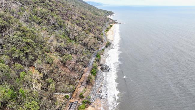
Douglas Shire mayor Michael Kerr said road infrastructure compromised by Jasper was at risk of complete destruction if further landslips were caused by more extreme weather.
“We’re still stood up because we’re still in a disaster,” Mr Kerr said.
“The rips in the mountain are the problem.
“Every time we get more rain, more earth enters the water. This then raises the turbidity in the water which shuts our system down. We can’t make clean water while turbidity is high.”
Mr Kerr said it was important that people don’t panic.
“The odds of having another rain event of that size is extremely unlikely,” he said.
“Cyclones take a long time to come in. There is no need to cancels bookings. It’s still at least a week away.”
In the Cassowary Coast, Jasper and subsequent rainfall levelled $30m of destruction to council roads and damaged 400 buildings.
A spokeswoman for the Cassowary Coast Regional Council said the council was monitoring the situation but had not yet activated its disaster management group in expectation of 05U colliding with the Far North coast.
EARLIER
A Coral Sea tropical low is now an 85 per cent chance of reaching cyclone intensity next week as the national forecaster warns of a “significant risk” that the storm will impact the Queensland coast.
Queensland east coast residents have been advised by the Bureau of Meteorology to stay up to date with forecasts and warnings amid a prediction that destructive winds of up to 224km could hit anywhere between Cooktown and Townsville.
The tropical low 05U is expected to become a cyclone by Monday.
Once sustained gales of 64km/h have blown for six hours or more the system will be named Kirrily.
The low will initially be slow moving on a general southerly track from Sunday to Tuesday. “Its movement then becomes uncertain but likely to come towards the coast,” the latest Bureau update reads.
Senior bureau forecaster Felim Hanniffy said of the 150 different scenarios fed through multiple forecast models, 80 per cent agree the system will potentially impact a huge area from Cooktown, south to Townsville and east to New Caledonia.
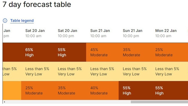
7-Day Tropical Cyclone Forecast shows a high (>50%) chance of a tropical cyclone in the Coral Sea from Monday. Uncertainty remains high with movement of this system, a coastal crossing remains possible.
— Bureau of Meteorology, Queensland (@BOM_Qld) January 18, 2024
Forecast: https://t.co/g0ekuwdTAG
Video Explainer: https://t.co/6LyPrDHORspic.twitter.com/jHDgfkexdr
“There is a lot of uncertainty, when you look at the outlook from Wednesday or Thursday, it could be off into the Coral Sea or it could cross the coast,” he said.
“At the moment a lot of models have it reaching cat 3 in intensity and in terms of wind gusts that’s up to around anywhere from 165 to 224km, which are destructive winds.
“We will get a track map maybe over the weekend, if it is going to form in the next 24 hours it will be the latter part of the weekend, you could say a named system will happen on Sunday or Monday.”
Mr Hanniffy said climate drivers – including the Madden-Julian Oscillation and the Rossby wave – that helped to create Cyclone Jasper continued to influence monsoon storm activity.
“It’s not usual, we have the climate drivers that helped from Jasper back in play again,” he said.
“The atmosphere is certainly conducive to an intense system.”
According to the ACCCES weather model the system will hit Townsville late Thursday night, while the GFS model has the system hitting Gladstone and both the ICON and European model predict no coastal impact.
Communities on the east coast of Queensland are advised to stay up to date with forecasts and warnings.
An erratically moving tropical low could potentially form into a “category 3 system or higher,” as the national forecaster predicts a possible coastal impact zone between Rockhampton and Cairns.
The Tropical Low 05U system will strengthen throughout the weekend and most likely power up into a tropical cyclone by Monday.
If the system does reach cyclone intensity it will be named Kirrily.
The Bureau of Meteorology has warned of a “significant risk” that the system will impact the Queensland coast during next week, however not all models agree that the storm will cross the coast.
“A severe impact is possible,” the latest Bureau update reads.
“It is too early to say exactly when or where the system might impact the coast. All communities on the east coast or Queensland are advised to stay up to date with forecasts and warnings.”
Cairns-based Bureau community information officer Daniel Hayes said if the system does track west, an impact zone between Cairns and Rockhampton was most likely.
“It’s still quite weak, there’s no circulation to the system, it’s quite a way off and moving east over the next few days,” he said.
“At this point while it’s a very weak system there’s a lot of uncertainty, it could track further east and there’s some modelling that says it will come back toward the coast.
“There is some indication it will form into cat 3 or above, it could be a significant system but it’s a matter of where it ends up going.”
If the low in the Coral Sea develops into a tropical cyclone, it will be called TC Kirrily. (So far @BoM_au gives that a 55% chance.) pic.twitter.com/CQdlorrOtS
— @phannam@mastodon.green (@p_hannam) January 16, 2024
On Wednesday the system was sitting 600km northeast of Cairns.
By early Tuesday the ACCESS weather model predicted the storm will impact the coast between Bowen and Townsville, producing 148km/h winds.
Throughout the northern cyclone belt spanning Western Australia, the Northern Territory and Queensland on average 11 cyclones develop in the summer months.
In Queensland alone this number drops to four but during an El Nino year this figure is expected to be lower.
Now midway through the season that runs from October through to the end of April, Queensland has a chance of being impacted by back-to-back tropical storms after the coastal crossing of Cyclone Jasper at Wujal Wujal on December 13.
“Definitely we are in quite an active phase of the monsoon,” Mr Hayes said.
“We still have the monsoon trough stretching between the (Queensland and NT systems) over the next few days. Around The Gulf and western edge of The Cape is where we will see the most rain.
“Up to 50mm on the north tropical coast (is expected) and we could see onshore flow rather than offshore flow.
“At this point we are not looking at convergence and we are not looking to have really heavy rainfall over the next few days but there will be showers.
“We have a week before there is any impact, now is the time to get the tidy up of any loose things.”
There is a low risk of Tropical Low 03U moving offshore and developing into a tropical cyclone on Wednesday which could move close to the Pilbara coast of Western Australia.
A tropical low developing in the Coral Sea is now a “high” chance of becoming a tropical cyclone at the weekend, according to the national forecaster.
Tropical Low 05U is initially expected to move east, away from the Queensland coast before powering up to cyclone intensity, however the Bureau of Meteorology is unclear on which direction the system will take from early next week.
A tropical low in the Coral Sea is now rated as a high (55%) chance of being a tropical cyclone from Sunday. The system is expected to remain offshore over the next 7 days, however uncertainty in its movement increases from early next week.
— Bureau of Meteorology, Queensland (@BOM_Qld) January 16, 2024
TC Outlook: https://t.co/hw63OUtpAPpic.twitter.com/nij1q6dvPh
“While it is expected to remain offshore for the next seven days, from early next week there is increased variation in potential movement,” the latest cyclone outlook stated.
“It may be moving west towards the Queensland coast or it may be moving through the central Coral Sea and further away from the coast.
Though no direct impacts to the Queensland coast are expected within the next week, the Bureau has warned there was a chance that the system could develop into a severe tropical cyclone on Monday or Tuesday.
The Bureau’s own ACCESS weather model predicts by Monday 150km winds at the eye of the storm will be 700km due east of Cairns.
While the European ECMWF model has the system 800km offshore on Monday, the GFS model predict the storm will be 1200km south east of Cairns and the ICON model has the system north east and 1000km offshore.
The two models (ECMWF and ACCESS) that predict a western track agree the system will cross the coast at Mackay next week.
According to the Bureau tropical low 05U is a 55 per cent chance of forming into a cyclone from Sunday.
A Coral Sea tropical low will intensify next week, according to weather forecast models.
But while the national forecaster has given the 05U system a 25 per cent chance of reaching cyclonic intensity, no coastal impacts are expected at this stage.
The Bureau of Meteorology has rated the developing system a low chance of forming into a cyclone on Friday, which will increase to a moderate chance by Monday.
The tropical low is expected to develop in the Coral Sea this week and move east before powering up and potentially moving back towards the southwest.
While 05U is expected to remain offshore for the next seven days, an accompanying monsoon trough will bring more heavy rain to north Queensland.
Senior meteorologist Miriam Bradbury advised north Queenslanders to keep an eye on the bureau’s seven-day outlook, as the directional track of the system was likely to change.
“The key thing to note is that is has not developed yet and it’s going to be moving away from Australia, and if it’s to develop into a cyclone the risk to the Australian mainland is nil, but that is seven days away and lot of things can change in that time,” she said.
“As soon as it shows any indication of coming back toward the coast that will be reflected in the tropical cyclone outlook.
“We do have a team of experts that are looking at the model and making assessments as to how it will develop.
“(But) we are expecting heavy rainfall over north Queensland associated with monsoon trough, locally heavy rainfall is likely throughout this week.
“Moderate rainfall is expected but isolated heavy falls are likely.”
⛈ï¸Tuesday forecast: severe thunderstorms with heavy rainfall are possible in the north and far north, and with heavy rainfall and damaging wind gusts in the northwest. Thunderstorms are possible across most of the state including #SEQld. Today's warnings: https://t.co/FBmpsInT9opic.twitter.com/WKBqfpOcQA
— Bureau of Meteorology, Queensland (@BOM_Qld) January 15, 2024
The Bureau issued a severe thunderstorm warning on Monday which is valid until Tuesday midnight.
Severe storms are possible from Bowen to north of Cooktown but an area north of Innisfail to Wujal Wujal, including Cairns falls within an area where storms are “possible”.
The Innisfail area has copped the heaviest falls in the past 24-hours to 9am on Monday.
The Marco Street Alert station, inland from Innisfail recorded 292mm, while Tinaroo Dam got 115mm, Mount Quincan 136mm, Euramo Alert 114mm and Cardwell 144mm.
On Sunday Cairns Airport recorded 85mm to log a running January total of 252mm.
The wet weather has prompted a reminder from police to not drive through flood waters, regardless of regardless of perceived capabilities.
The warning followed an incident in Julatten involving the flooded Bushy Creek Bridge.
A 66-year-old Earlwood man, was forced to abandon his vehicle after quickly rising water entered the vehicle.
Motorists are reminded that during severe wet weather, road surfaces can be washed away to create dangerous situations for vehicles attempting to drive across.
Crossing a flooded road places not only yourself at risk, but also the lives of those who may need to rescue you, police stated.

Originally published as Far North southern region hit with heavy rain and damaging winds
Join the conversation

Inside Oli Frost and Johnny Eddings’ mega $1.25m court battle
A $1.25m loan from a South Australian entrepreneur and influencer, secured in the dying weeks before Oli Frost and Johnny Eddings’ The Grass is Greener music festival lurched into voluntary administration, has come back to haunt the pair.
Read more

‘Haunted’ by drink-driving accident that seriously injured woman
A remorseful drink driver who caused a woman grievous bodily harm in an accident when he sped through a stop sign near Edge Hill Bowls Club has asked a magistrate if he can do community service to ‘give back’.
Read more