BOM confirms monsoon season will be latest on record if it occurs after January 25
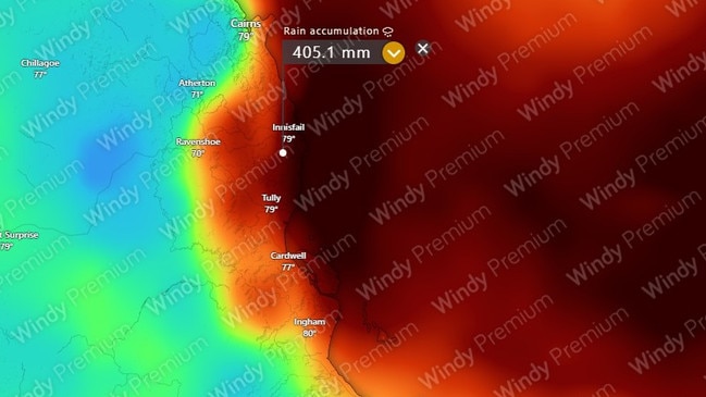
Some forecast models are predicting the formation of the season’s first Coral Sea tropical low off the coast of Cairns next week and rain accumulation exceeding 300mm is expected in the next seven days.

Cairns
Don't miss out on the headlines from Cairns. Followed categories will be added to My News.
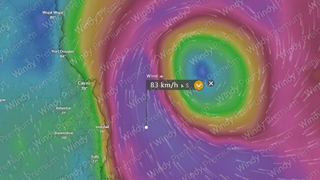
Forecast models have begun predicting the formation of the season’s first Coral Sea tropical low off the coast of Cairns next week, with a rainfall accumulation expected to exceed 300mm in the next seven days.
While not yet a cause for concern, the ACCESS long-range wind forecast from next Friday is predicting telltale circular wind formations will develop 300kms off the coast of Cooktown.
By Saturday, February 1, the system is forecast to move south to be 200km east of Cairns.
The European Centre for Medium-Range Weather Forecast model shows a messier pattern, with the system forming later before tracking east toward New Caledonia.
Bureau of Meteorology meteorologist Angus Hines said the developing situation was definitely on the radar of national forecaster’s weather boffins.

“If you look each day you see slight variations on those long range forecasts, it’s certainly an area we are looking at quite closely,” he said.
“It’s been relatively benign this season but those long-range forecasts are looking a lot more active and there’s an eagerness for forecasts to develop into some kind of tropical weather pattern but if that’s a tropical low or full-blown cyclone, that remains to be seen.
“That Coral Sea area which is our prime breeding ground (for cyclones) is potentially coming to life in early February.”
In terms of rain, Mr Hines said wet weather was not expected to wash out Australia Day celebrations on Sunday, but such a late start to tropical precipitation meant a potentially record-breaking kick off to the monsoon season.
“I can’t confirm this will be the latest start to the monsoon, though it’s looking likely,” Mr Hines said.
“The latest on record is January 25 and we have a couple days left to see an official monsoon onset for it not to be a record, so we won’t be able to confirm until after (January 25).”
Mr Hines said to expect decent rain from Monday and by February, consistent rain was a chance of triggering flooding of Far North river catchments.

“We are going to experience an up-tick in rain starting from the end of the weekend, from Monday the falls will kick in and the easterly surge will push rain onshore,” he said.
“Every day next week it is likely to stay wet over the north tropical coast area.
“It can accumulate pretty quickly and we could see triple figures and 200-300mm of rain is possible.
“Daily rainfall fall between 10-40mm across the coast is expected and potentially in the second half of the week we could get flash flooding.
“The rivers slowly get higher and higher and some of those northern rivers may breach flood levels, and our flood forecasting team will be looking closely.”
The rain could be the first test of the Queensland Flood Warning Infrastructure Network that late last year became the management responsibility of the Bureau.
According to Mr Hines the technical definition of the monsoon is the flow of westerly winds across Darwin.

“It has to do with the wind direction, strength, and persistence of the wind – it’s go to be a westerly wind through the lowest 5km of atmosphere, at persistent speed, and if is sustained for a significant period of time, often 24 hours, then we declare the monsoon arrival,” he said.
Hr Hines said while the wind’s arrival was unlikely to occur in the next few days, it was always accompanied by extensive cloud cover and rainfall.
“The main impact to weather is cloud, rain, cooler temperatures,” he said.
Mr Hines said Far North residents could expect a damp public holiday weekend with light falls of up to 15mm expected for Cairns and surrounding areas before the arrival of heavier falls next week.
“The next few days into the working week, we can expect predominantly dry days with a mixture of sunshine and cloud overhead, a slight chance of a shower or two but no heavy rain,” Mr Hines said.
More Coverage
Originally published as BOM confirms monsoon season will be latest on record if it occurs after January 25


