
Flooding chaos as parts of Victoria, NSW under water
Major cities on the east coast are flooding as rainfall lashes multiple states, with warnings the wet weather isn’t going anywhere.
Environment
Don't miss out on the headlines from Environment. Followed categories will be added to My News.
Two major cities on the east coast have reported flooding as a massive drenching continues to soak soils and overwhelm roads.
A flash flood watch and act warning was issued for the Melbourne inner-city suburb of Elwood and the southeast suburb of Frankston.
Residents are being warned to move indoors, away from floodwater.
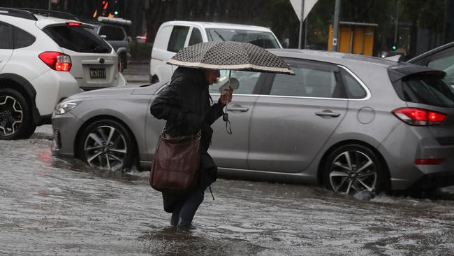
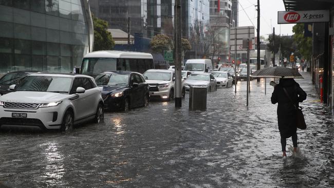
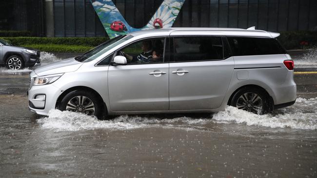
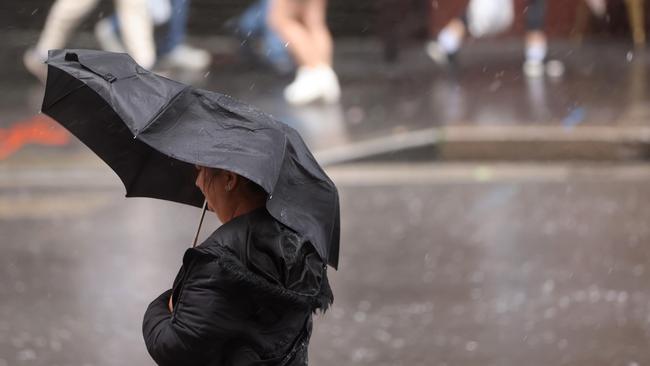
Roads in the city centre have taken on a significant amount of water as cars and pedestrians struggle to move around the CBD.
In regional Victoria, a moderate flood warning has been issued for Loddon River Laanecoorie to Loddon Weir and Avoca River to Charlton Town in the state’s west.
Charlton Town residents are being advised to move to higher ground.
In the 24 hours to 9am on Friday, rainfall totals of up to 65mm have been observed across the Loddon River and Avoca River catchments.
On the border of Victoria and NSW, a moderate flood warning is being issued for Albury, Corowa and Bondiana.
Sydneysiders are being warned to brace for more wet and miserable conditions after the city broke its yearly rainfall record.
Parts of west and northwest Sydney have started to report minor flooding on Friday morning.
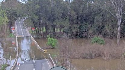
Wiseman’s Ferry Bridge on the Lower Hawkesbury River north of Sydney has become submerged under water, while at North Richmond the Hawkesbury River is at 4.92m and falling, with minor flooding.
This year officially became Sydney’s wettest on record when it surged past the previous highest annual rainfall total around 1.30pm on Thursday.
The 2194mm benchmark had stood since 1950, with rainfall annual amounts recorded since 1858.

While it was forecast that Sydney would break the record this week, it was expected it would happen over the weekend.
Bureau of Meteorology meteorologist Jonathan How explained Thursday’s heavy falls of around 90mm were “very much beyond” what was anticipated and led to the “quite significant” record being broken.
While Sydneysiders woke to sunny skies on Friday, Mr How warned it was only a minor reprieve from the deluge until the afternoon.
2022 has been a truly exceptional year of rainfall in #Sydney. It only took 279 days to break the city’s annual rainfall record of 2194mm from 1950, with annual data available back to 1859. pic.twitter.com/z6RtCopxqO
— Ben Domensino (@Ben_Domensino) October 6, 2022
“There‘s more on the way, there’s another 40 to 80 up to 100mm on the cards with the two next systems coming down. The first one this afternoon and the next one tomorrow and then Sunday,” Mr How told the ABC on Friday.
“Thankfully, we do see a couple of dry days on Monday and Tuesday.”
Sky News meteorologist Rob Sharpe had a similar message, with Saturday shaping up to be NSW’s “danger day” with up to 100mm of rain expected in isolated parts of the state.
The final rain band on Sunday will turn into a more intense low-pressure system, meaning “we will see the heaviest rain for the event for many locations as that runs down”.
“It will also become pretty windy. We could see a severe weather warning for damaging winds on Sunday,” Mr Shape said.
The bureau has issued a severe thunderstorm and heavy rainfall warning for parts of southern NSW on Friday.
Flash flooding is possible in the Riverina, Central West and lower western districts due to the downpours.
Current temperature and radar for #NSW. Today there's the chance of thunderstorms across most of the state, these are more likely this afternoon and evening. More rain expected over the weekend for much of the east.
— Bureau of Meteorology, New South Wales (@BOM_NSW) October 6, 2022
Monitor forecasts, warnings and radar: https://t.co/REl2VBlGnApic.twitter.com/S71x4bnHx5
NSW SES had issued 57 flood warnings across the state as of 8.30am on Friday. Fourteen were to “watch and act”, the rest were “advice” warnings.
The bureau has advised major flooding is possible in the following areas:
- Gwydir
- Namoi
- Macquarie
- Lachlan
- Belubula
- Bogan
- Wollombi
- Brook
- Goulburn
- Hunter
- Macquarie
- Darling
- Culgoa
- Lachlan
Flood watches are also in place across Greater Sydney, including a minor warning for the Hawkesbury and Nepean rivers.
NSW SES received 324 calls for assistance in the 24 hours to 10am on Friday. Four of them were flood rescues.
Many communities are already experiencing flooding or are at greater risk due to saturated soils following a wetter than usual spring.
NSW Emergency Services Minister Steph Cooke said the state government understood it would be an anxious time for people in those areas.
“We are very conscious of the fact that your communities have experienced four floods within an 18-month period and acknowledge the anxiety that some of you will be feeling at this time,” she said.
NSW SES Superintendent Josh Clark said the forecasts in some areas were “very similar” to the heavy rain they has experienced over the last year and a half.
He said the SES had positioned people in those at-risk areas to ensure they were prepared if the worst did eventuate.
“Thankfully, at the moment we do not have any communities that are at risk of evacuation or preparing for evacuation,” Superintendent Clark said.
“That does not mean though that those residents in those areas should not be taking that preparation already.”

With the Bathurst 1000 in full swing, NSW Police Superintendent Bob Noble urged those in attendance to stay away from flooded roads and areas.
“It wasn‘t very long ago that we had a five-year-old boy, not far from here who was killed. Drowned in a car washed off a bridge,” he said.
“You can imagine how devastating that is for that family. It is a terribly hard way for a lesson to be learnt by society, but let’s learn that lesson. Let’s not have it happen again.”
Further south in Victoria, more thunderstorms and heavy rain has been forecast for central and eastern parts of the state on Friday
The bureau has warned these storms may turn severe across northeast areas, while continued river rises are a threat in multiple regions.
Victoria SES had issued 44 flood warnings as of 8.30am on Friday.
Strong wind warnings have also been issued for the west and East Gippsland coasts.
More showers and storms on the way for #Victoria today, with the focus on central/eastern parts. There is a chance that storms may tend severe across parts of the NE. ⛈ï¸
— Bureau of Meteorology, Victoria (@BOM_Vic) October 6, 2022
Details: https://t.co/XoiXZ3VINm#FloodWarnings also current, find the latest here: https://t.co/HLs2UYFQyQpic.twitter.com/Z7l5t0zm3D
Up north in Queensland, severe thunderstorms are possible in the southwest of the state on Friday.
Thunderstorms are possible across the west and the southern interior, with rainfall expected to increase throughout the day.
Minor flood warnings are in place at several river catchments across the state.
Originally published as Flooding chaos as parts of Victoria, NSW under water

Double trouble wet weather for country
Parts of Australia that have already experienced a wet weekend should expect more downpours in the week ahead.
Read more

‘Big’: Wild weather warning to Aussies
Aussies in several states have been warned to brace for a weekend of wild weather, with the risk of floods and damaging winds.
Read more