
Mapped: Australia’s severe weather forecast
The nation could be in for a double whammy of flood and fire emergencies this spring and summer. See the forecast for your state.

Environment
Don't miss out on the headlines from Environment. Followed categories will be added to My News.
Australia could be in for a double whammy of flood and fire emergencies this spring and summer, with heavy rains forecast in some states and extreme heat expected to dominate in others.
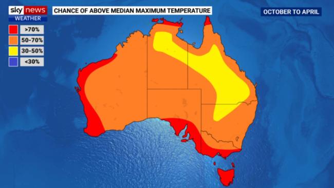
According to the Sky News Weather Severe Weather Outlook, released on Tuesday night, New South Wales, Queensland and the Northern Territory will be wetter than usual, while Victoria, South Australia and Tasmania face a higher risk of heatwaves, drought and bushfires.
Preparations for the season are underway, with emergency services convening in Canberra last week for a two-day National Preparedness Summit where they war-gamed disaster scenarios.
The Summit “significantly enhanced our national readiness,” the National Emergency Management Agency Coordinator-General Brendan Moon said.
Firefighting efforts will be boosted by the acquisition of three new aircraft for the national aerial firefighting fleet by summer, while 69 critical water-level gauges will be moved from third party ownership to the Bureau of Meteorology by December, including on the flood-prone Burdekin, Logan, Albert and Condamine Rivers in Queensland.
The acquisition of the gauges is the start of a 10-year, $236 million project to bring more of the units under the control of the Bureau, after reviews of previous flood disasters found inconsistent levels of monitoring and maintenance among the country’s existing network of 8000 gauges.
“By doing this, we can give Australians early warning of flood activity, which makes it easier for them to prepare themselves, prepare their families and their property, to better protect life and property,” Environment Minister Tanya Plibersek said on Tuesday.
Sky News Weather Meteorologist Alison Osborne said the expectation of warmer and wetter conditions meant an increased likelihood of a “very active, stormy summer” on the east coast, after a year in which many centres, including Sydney and Perth, had swung between deluges and extremely dry periods.
“It’s been very turn-on-the-fire hose, turn-off-the-firehouse in different parts of the country,” she said.
With regards to tropical cyclones, Ms Osborne said Australia was likely to see fewer than the average (11) this season, but climatic conditions also pointed to “a higher likelihood of severe tropical cyclones”.
In the last severe weather season, there were eight tropical cyclones in the region, of which four made landfall – but there was no way to predict how many cyclones in a season would hit the coast, Ms Osborne said.
“The thing that we very often say is a cyclone has made landfall in Australia every single season since reliable records began, so if you live in northern Australia and we are forecasting a close to average cyclone season, you need to prepare for that,” she said.

The split picture for Australia this coming season – with some states on flood watch and others on alert for bushfire – is partly a product of the fact that there’s no one phenomenon currently dominating. The Bureau of Meteorology remains on “La Nina watch”.
Research published on Tuesday by Dr Mandy Freund from Melbourne University suggested there was just a 16.7 per cent chance of a La Nina forming this November or December.
Australia last had a “neutral” summer – neither La Nina or El Nino – back in 2019/20, but according to Dr Freund’s research, the likelihood of consecutive “neutral” summers is decreasing.
For the full Severe Weather Outlook and a state-by-state breakdown visit SkyNews.com.au or download the Sky News Australia App.

Millions brace for brutal cold fronts
A fresh wave of wild weather is preparing to lash Australia, bringing freezing winds, thunderstorms and icy blasts to millions.

Update on flights after volcanic eruption
Not all Australian airlines are ready to fly again following Monday’s volcanic eruption in Indonesia.