
Fire bans as flooding hits other corners of Australia
The various corners of Australia are facing cyclone, fire and flooding threats on Thursday as the extremes of Australia’s climate take hold.

Environment
Don't miss out on the headlines from Environment. Followed categories will be added to My News.
Victoria is on high alert for fires, as dry thunderstorms are expected on Thursday afternoon.
The threat to central areas comes as western areas of the state are subject to flood warnings.
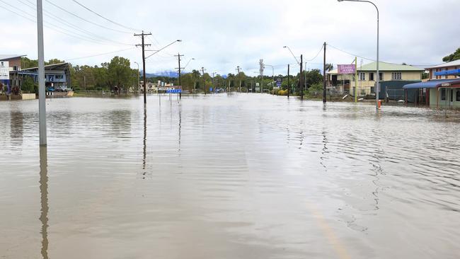
Parts of North Queensland are still under major flood warnings, nearly two weeks after a days-long deluge claimed two lives in the town of Ingham.
And severe thunderstorms with heavy rainfall will continue in the northeast corner of NSW after Lismore recorded nearly 100mm of rain in two hours early on Thursday.
The Bureau of Meteorology is forecasting dry thunderstorms to form and roll through central Victoria beginning Thursday afternoon.
“Hot with ‘fresh’ to strong and gusty northerly winds ahead of a milder, gusty west to southwesterly change extending from the west during the afternoon and evening,” the bureau warning says.
“There is a risk of high-based thunderstorms and dry lightning, most likely in central parts in the afternoon.”
The forecast has prompted a fire weather warning; residents need to have their fire action plan ready and keep across the most recent forecasts.
Thursday has been declared a total fire ban day for Victoria’s South West, North Central and Central areas, including Melbourne and Geelong.
“A high pressure system over the southern Tasman Sea extends a broad ridge west over Victoria while a low pressure system and associated cold front crosses the Bight,” the bureau says.
“Both systems combine to direct a warm northeasterly airstream over the state.”
A possibly severe thunderstorm is forecast for Shepparton on Thursday night after a top of 37C.
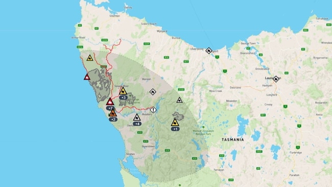
The same confluence of weather systems is bringing strong winds to the west coast of Tasmania on Thursday morning.
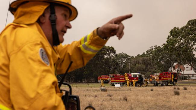
Tasmanian authorities are already battling fires. Sparked by dry lighting 11 days ago, some 50,000 hectares have been burned on Tasmania’s isolated west coast.
Take shelter now warnings were issued for Sandy Cape on Thursday morning.
“An uncontrolled bushfire at Sandy Cape and surrounds is expected to put lives in danger and may destroy homes now,” the Tasmanian alert says.
“Fire conditions are expected to be uncontrollable, unpredictable and fast moving. The fire is travelling towards Sandy Cape.”
Back in Victoria, riverine flooding out to the east has eased. The Avon River at Stratford had been flooding earlier in the week, but in an update about lunchtime on Wednesday, authorities said the threat had reduced. However, thunderstorms are forecast for Friday and into the weekend across the catchment, so river levels could rise, but any rise is expected to be only minor.
Northward, a moist and unstable air mass is producing slow moving severe thunderstorms in the NSW Northern Rivers and areas along the Queensland border.
In the hours before noon on Thursday, severe thunderstorms are likely to produce heavy rainfall and flash flooding at Tweed Heads, Murwillumbah, Hastings Point, Numinbah, Tyalgum, Mullumbimby and Brunswick Heads.
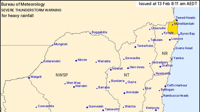
In Queensland, flash flooding is possible on the Gold Coast and in Coolangatta.
At Lismore, 86mm of rain fell in two hours early on Thursday.
In North Queensland, river systems are still under flood warnings, more than a fortnight since a major rain dump made landfall and less than two weeks since the flooding peak claimed two lives in and around the town of Ingham.
The Flinders and Herbert rivers are still subject to major flood warnings, and a host of other catchments are under minor to moderate warnings.
The Bureau of Meteorology has warned WA residents on the Pilbara coast about the “rapid intensification” of Tropical Cyclone Zelia.
Senior meteorologist Dean Narramore said Zelia was a category 3 system about 130km north of Port Hedland on Wednesday evening and had continued to move “very slowly” to the west.
“We’re likely to see it intensify later this morning into a category 4 and then as we get into the afternoon and overnight hours into a category 5 system,” Mr Narramore said.
“Then tonight into tomorrow, we’re likely to see it start turning towards the WA coast as a category 5 system and at this stage crossing to the west of Port Hedland Friday afternoon into (the) evening as a category 5 system.”
Originally published as Fire bans as flooding hits other corners of Australia

Aussies stranded after volcanic eruption grounds Bali flights
Flights to and from Bali have been cancelled or delayed after a volcano erupted on a popular Indonesia tourist spot. See flights affected.

Reason housing crisis could get worse
Australians are already facing a shortfall of more than 640,000 affordable homes. There’s one reason that might get even worse.