
Minister Emergency Services warns wet weather is here to stay all summer
BOM has warned the worst weather is far from over as one expert offers a grim outlook for summer.
Environment
Don't miss out on the headlines from Environment. Followed categories will be added to My News.
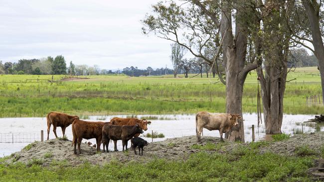
As flood-torn areas in NSW and Queensland continue to recover from unprecedented levels of rain, it appears the wet weather is likely to continue.
Minister for Emergency Services for New South Wales Steph Cooke has warned residents in flood prone regions that the worst could be yet to come.
“My message is, please don’t be deceived,” she said.
“The sun might be out in various parts of the state, we may be seeing some dry conditions at the present, but our rivers continue to rise and we know that there is another event coming through.
“We may see a reprieve for a few days but ... [we] will be heading into some more difficult conditions towards the end of the week.”
It comes as Prime Minister Anthony Albanese told reporters the Federal Government has made themselves available to provide assistance at the request of the state government.
“My heart goes out to those people who have suffered time and time again,” Mr Albanese said.
The Bureau of Meteorology warned more residents would be urged to evacuate over coming days as 100km/h winds and heavy rainfall hit the state.
“We’re in for a long spring and summer in relation to wet weather conditions,” Ms Cooke said.
“Our dams are full to overflowing. Our rivers are full. They are at capacity. And our ground is saturated.
“We are asking on that basis for people to please stay informed.”
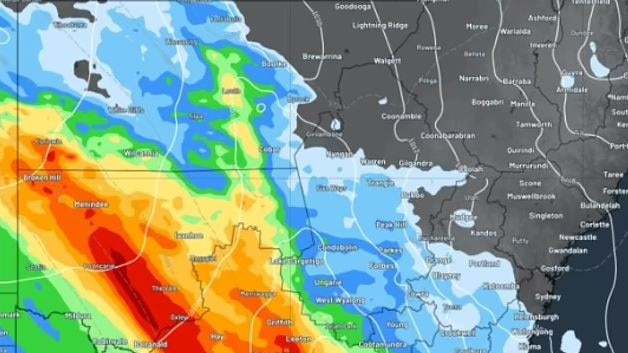
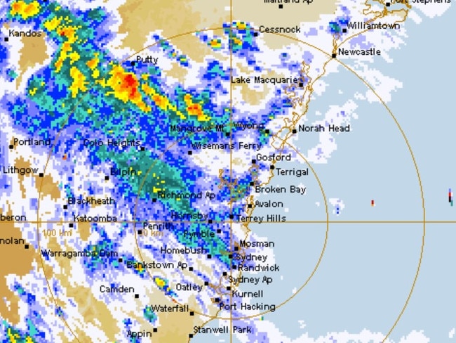
Just over the last 24-hour, wide spread totals of up to 50mm of rain were captured across western and central-western slopes.
Along the coast, another 50mm-70mm of rain fell, with some areas copping levels above 100mm.
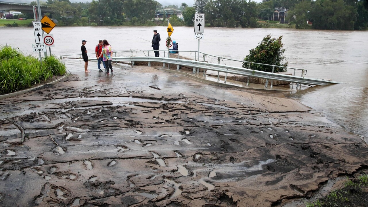
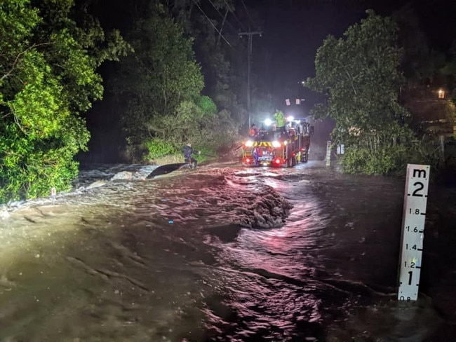
NSW SES is directing people in low-lying farmland in Agnes Banks near Richmond and Lower Portland east of the Hawkesbury River to evacuate before 5pm.
Once flood waters reach 7 metres at the Window gauge, people may become trapped without power, water and other essentials.
An evacuation centre is open at Castle Hill RSL.
While residents of the Riverside Ski Park in Cattai are under orders to evacuate by Sunday 6pm due to dangerous flooding. Road access may be cut off as the area is inundated.
Residents of the Western Plains Tourist Park, in Dubbo and Gronos Point, northwest of Sydney were ordered to evacuate earlier this morning.
Bureau of Meteorology spokesperson Jane Golding said that the state can expect a couple of days of relief for the start of the week, but more is due to come.
“We should see a couple of days of fine weather for the most part but flooding will remain for the next few days,” she said.
“Unfortunately, this is the time of the year we see a series of fronts move through New South Wales and there is another one expected to come into the west of the state on Wednesday.”
The Australian Defence Force was called in to help with rescues across New South Wales as the state braces for more wild weather and flooding.
A low pressure system located just off the NSW central coast will deepen as it moves eastwards further off the coast throughout Sunday.
BOM senior meteorologist Dean Narramore said while heavy rainfall will ease by Monday, the worst is yet to come.
“Although the rain will ease up from today, the worst is not over I am afraid,” he said.
“NSW will get a few dry days before another weather system just as bad hits the coastal areas on Wednesday.
The NSW coastal town of Ulladulla has seen the biggest downpour in the last 24 hours with 110mm of rain with the Sydney metropolitan area receiving 40-60mm of rain.
“It is more worrisome because of the already severe flooding situation in NSW, any rain after this will simply add on to that severity,” Mr Narramore said.
Forecasters are predicting damaging winds, averaging 60 to 70 km/h with peak gusts in excess of 90 km/h along NSW’s east coast.
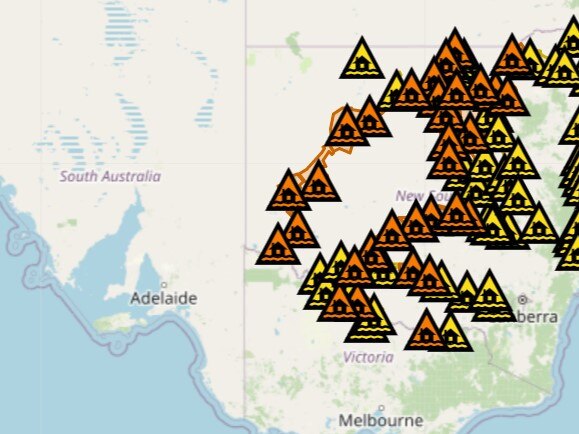
While the heavy rainfall is expected to ease on Sunday, 80 flood warnings are still in place and a flood watch will remain in place for much of the state.
Three emergency orders are in place with emergency services most concerned about Bathurst, Mudgee, Dubbo, Canowindra, Nyngan, Narromine and Warren, in western NSW.
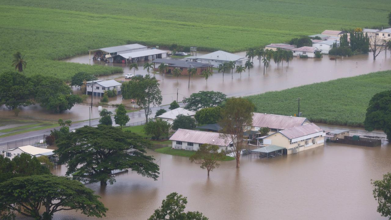
The Macquarie at Narromine is expected to peak at about 11m later today and will continue on to Warren, where it is already majorly flooded.
The Macquarie Wambuul River at Dubbo is expected to peak at about 8.5 metres this morning, forcing the evacuation of a nearby caravan park, Western Plains Tourist Park, and inundation of shopping centre‘s car parks on the city’s Main Street.
Emergency services has responded to more than 600 requests for assistance and carried out 26 flood rescues.
Evacuation centres have been set up at the Dubbo Showground on Wingewarra Street.
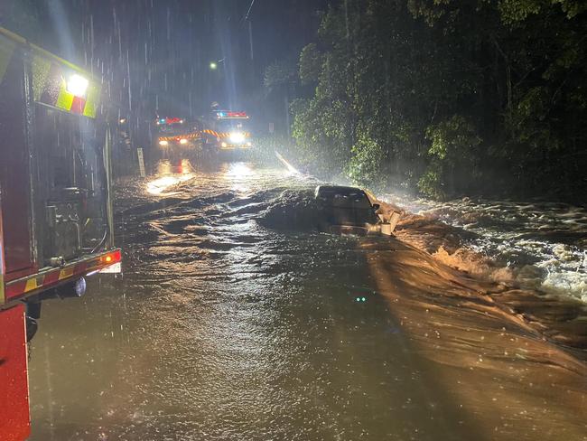
Pictures taken from Otford and Helensburgh show firefighters rescuing a local trapped on the roof of their car.
There‘s been flash flooding in Mudgee with a land slip impacting on the Castlereagh Highway and numerous local roads closed. There was also flash flooding between Dubbo and Wongarbon.
The low-level bridge at Bathurst is closed along with many roads in and around the city.
It comes as 200,000 Bathurst 1000 fans attempt to leave the city after Sunday’s main race and travellers make their way home after school holidays.
Widespread falls of 40 to 50 millimetres were recorded, and there were some significantly higher rain totals from isolated storms.
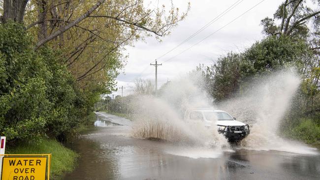
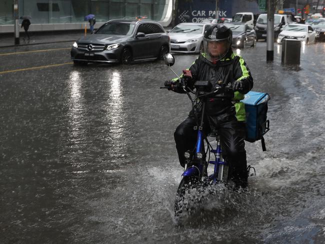
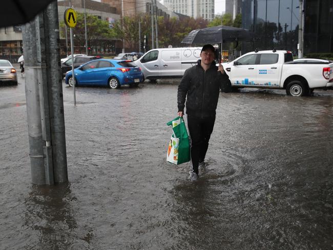
Flash flooding in NSW is still possible despite heavy rainfall over the Greater Sydney region has been easing.
Residents in some areas northwest of Sydney have been told to prepare to get cut off by rising floodwaters, with 28 watch-and-act flood warnings active across the state.
A Hazardous Surf warning is current for the Macquarie Coast, Hunter Coast, Sydney Coast and Illawarra Coast.
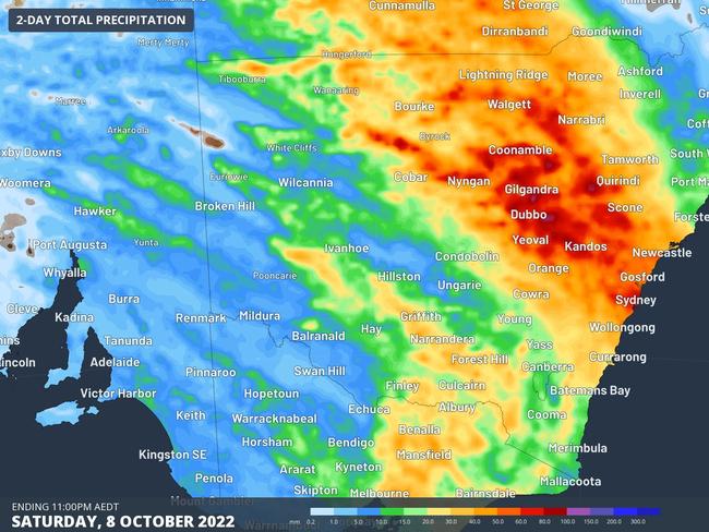
NSW faced a massive deluge of rain on Saturday night, after a massive 400km band travelled from east to west across the state.
Heading into the evening, residents were warned to brace for flash flooding, landslides and strong winds as the low pressure system dumped rain across large swathes of the state.
East coast residents have been warned the big wet could stick around for weeks and months.
On Saturday afternoon there were 63 flood warnings in place with dams and rivers still full following recent deluges.
Prior to the significant event, residents across the state were warned of the risk of flash flooding.
“We are expecting overnight heavy rainfall in Sydney as it moves up from the west, so there is significant risk of flash flooding right across our state,” Premier Dominic Perrottet said on Saturday afternoon.
“We currently have a situation where our dams are full, our rivers are full, so with heavy rain expected we ask everybody to continue to be cautious.
“If those flood warnings are in place, please continue to follow instructions, be prepared and be ready if an evacuation is needed.”
The deluge forced Saturday’s iconic Top 10 Bathurst Shootout to be cancelled because of unsafe track conditions caused by the torrential rain at Mount Panorama.
The iconic single-lap qualifying dash had been due to get underway at around 5pm (AEDT) but race organisers deemed the track was too wet to drive on.
It comes after the city broke its all-time yearly rainfall record of 2194mm earlier this week.
On Saturday evening, the SES issued its first evacuation order, with residents urged to leave Oura Beach Camping Area, just west of Wagga Wagga, before 9am Sunday.
“You must evacuate before this time because inundation to the area and access road may be cut,” the SES said in its emergency warning alert.
Originally published as Minister Emergency Services warns wet weather is here to stay all summer

Top 10 Aussie beaches revealed
Move over Bronte and Byron Bay, Australia has a new best beach according to the national tourism council
Wild weather leaves passengers stranded
Passengers hoping to get a flight out of a popular holiday spot have been turned away after a regional airport closed its doors amid wild weather.