
Australia’s weather extremes — flash flooding and heatwaves
A WEATHER double-whammy is causing the atrocious downpour which has seen some parts of NSW hit with more rainfall than in a generation.
technology/environment
Don't miss out on the headlines from technology/environment. Followed categories will be added to My News.
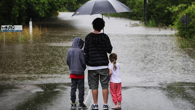
THE people of Newcastle and the Hunter Valley must be wondering what they did wrong.
While the whole of NSW, and much of Queensland, have suffered through soggy downpours it’s the area around NSW’s second city which has born the brunt of the deluge with some of the heaviest rain seen for 25 years.
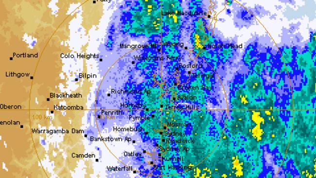
According to the Bureau of Meteorology more than 250mm of rain has fallen in the southern suburbs of Newcastle — an occurrence which has only a two per cent chance of happening in any given year. Rain is also continuing to lash much of the state’s coast including Sydney.
TWO TROUGHS
The culprit is a low pressure system which formed offshore. Blown inland it has combined with a tropical low heading down from the north to bring flash floods and severed transport links.
While meteorologists say a break may be coming, the sheer amount of water dumped in northern NSW could cause chaos for days.
The State Emergency Service has ordered an evacuation of homes in Raymond Terrace, north of Newcastle, after flood waters from the Hunter River started to inundate the lower areas of the Raymond Terrace CBD.
TRAPPED
Meanwhile, at least 21 campers who have become trapped by floodwaters in southern NSW.
Bendethera Valley campground west of Moruya has been isolated by heavy rains and flooding with at least 16 adults and five children trapped at the site, an SES spokesman told AAP.
“There has been no direct contact since Sunday ... they have been isolated since then,” he said.
The campsite is extremely isolated and without mobile phone reception, making it hard for crews to understand the conditions in the site but it’s likely they will be running low on food he said. Search crews couldn’t reach the campground on Tuesday and difficult weather was causing problems for the Rescue Helicopter to land in the area
Elsewhere, homes are without power, rail lines are closed and 100 calls have been made to the ambulance service due to accidents on waterlogged roads as the state struggles through yet another day of sopping weather.
Flooding in #raymondterrace @NSWSES @NSWRFS pic.twitter.com/3Sb7Z3pEjn
— Nick Moir (@nampix) January 6, 2016
TWO TROUGHS
Senior meteorologist, Peter Zmijewski, told news.com.au while much of the recent wet weather had been caused by a broad low pressure trough dragging moist conditions down from the tropics, there was more to the story in Newcastle.
“That system came across most of Australia but it didn’t have as much of an effect as elsewhere because here we have got another system forming off the Hunter Coast.
“It’s a combination with the low pressure system forming offshore which has brought all of this heavy rainfall,” he said.
“The low is moving away towards the north and north east but very slowly. We should see the rain easing into the evening and overnight with showers down the coast tomorrow but not as heavy as today,” Mr Zmijewski continued.
Emergency services have warned residents should stay away from rising waters as heavy rain hammers the state, and for some it is about to get even worse.
HOMES WITHOUT POWER
Electricity supplier AusGrid is working on restoring power to more than 2000 homes around Swan Bay and Lemon Tree Passage, north of Newcastle, and west of Wyong in the Central Coast after felled trees cut power lines.
Newcastle Airport, at the heart of a drenched Hunter Region, was closed when water washed across the runway. It reopened this fatrenoon.
NSW TrainLink services have also been affected with buses replacing Hunter line services between Hamilton and Scone and Dungog in both directions due to flooding of the line at Sandgate.
@702sydney St James station is a bit damp right now pic.twitter.com/xHEIeR7s8J
— Belinda Cherie (@bellarahhh) January 6, 2016
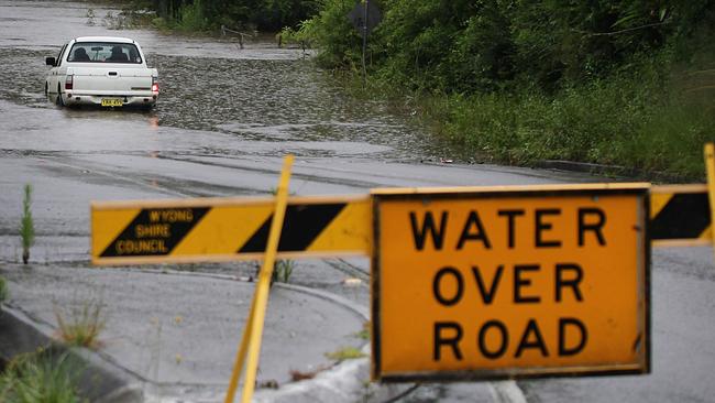
Flooding is also causing delays and closures to roads around the Hunter with 40 alerts in place including on parts of the A1 highway around Beresfield and Hexham, just north of Newcastle.
NSW Ambulance Service executive director for service delivery, Jamie Vernon, said the organisation was on high alert in the Hunter and the Dungog, Stroud and Gloucester areas where flooding is causing street closures. Two special operations team paramedics are on standby at Raymond Terrace.
“NSW Ambulance remains alert to notifications from the State Emergency Service and NSW Police in regard to river levels, and road closures and alternate routes,” Mr Vernon said.
“We would like to remind motorists not to attempt to drive through flooded roads and across flooding rivers.”
Residents returned to homes in Dungog after evacuation notices were issued on Tuesday night to about 10 streets in the town, west of Newcastle.
Jodie Francey told AAP that people in the town were on tenterhooks because of the devastating floods in April but conditions didn’t seem to be as bad. “I think the amount of rain gave people a case of deja vu ... there are still people that aren’t in their homes.”
New flood warnings were issued this morning for eastern NSW, with the greatest danger in the Hunter Region where major flooding is expected. Damaging winds are also possible.
Evacuations began last night in Dungog, one of the hardest hit areas. Last year the town was hit with a flood crisis that claimed lives and carried whole houses away. Some homes have already been flooded, but police said residents had been evacuated safely.
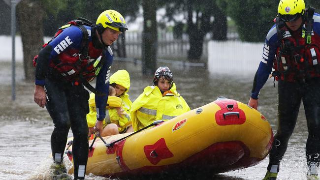
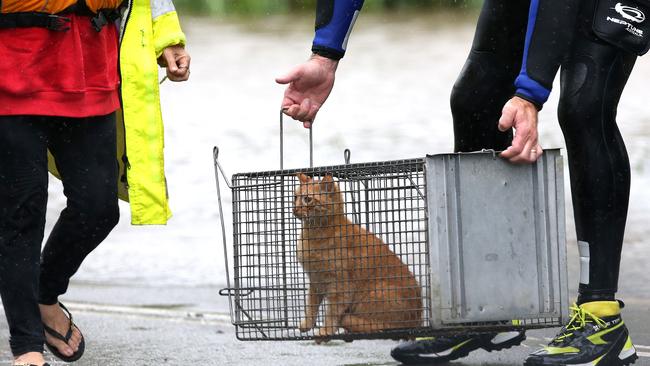
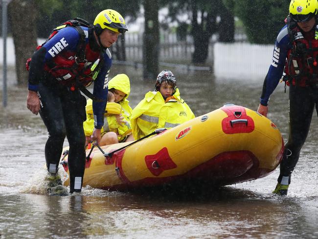
RESCUES
Further south, four German tourists had to be rescued after their car became irretrievably bogged while driving on a bush track in the Olney State Forest on the Central Coast on Tuesday afternoon. The men waited nearly seven hours while crews searched for them, eventually finding the men at 11pm.
There have been 21 rescues carried out since the heavy rain began on Monday, with the majority of them occurring overnight, State Emergency Services deputy commissioner Greg Newton said this morning. There has also been about 1400 calls for assistance, many of them for roof damage and leaking.
The Bureau was forecasting falls across Sydney today of between 10mm and 25mm with higher falls expected along the coast.
Queensland has escaped the heavy rain, with parts of Brisbane being hit with 30mm yesterday. Combined with downpours the day before the area has now had up to 70mm in two days.
The normally packed beaches of the Sunshine and Gold Coasts were almost deserted yesterday as the gloomy weather drove holiday-makers indoors.
It’s a different story in Victoria, though, where milder temperatures and conditions have allowed fire crews to build containment lines around fires that may burn all summer.
Temperatures are forecast to soar back into the mid-thirties next week though.
Mr Zmijewski said showers could be expected anywhere in NSW throughout the week but there would be a marked improvement in the weather, particularly around the south coast which suffered flooding earlier in the week “Friday looks like the best day over the next few and it could should be quiet pleasant if you don’t mind a sprinkle.”
- with AAP.
An EVACUATION WARNING has been issued by the NSW SES for low lying areas of Dungog due to the rising levels on... https://t.co/GxMCeMHlhG
— NSW Incident Alerts (@nswincidents) January 5, 2016WALLSEND | #FRNSW f/fighters are assisting @NSWSES evac'ing residents & motorists trapped by floodwaters. pic.twitter.com/hFCFnqoVMk
— Fire & Rescue NSW (@FRNSW) January 5, 2016
Originally published as Australia’s weather extremes — flash flooding and heatwaves
‘Dire’: Shock drought reality hitting Aussies
Young mums are running out of water and farmers are on the brink as one state battles widespread drought conditions.
Community forced to self-evacuate in cyclone
A remote community in the Pilbara was forced to self-evacuate overnight as floodwaters in the wake of Cylcone Zelia threatened the town.