
Nearmap: Shocking Flooding photos show Forbes, Wagga Wagga devastation
Devastating aerial photos show the impact of flooding in the state’s central west. See the shocking impact in new aerial photos.

The Wagga News
Don't miss out on the headlines from The Wagga News. Followed categories will be added to My News.
They are shocking aerial photos that show the sheer devastation of the flooding emergency across the state’s central west, west Nearmap reveal the impact in a series of flyovers in Forbes and Wagga Wagga.
Forbes
The central west town of Forbes has seen some of the worst flooding in 70 years, with the Lachlan River bursting its banks last week and peaking at 10.7 metres on Saturday evening.
A number of buildings and businesses in the town’s CBD have been heavily impacted by gradual flooding along with farming properties severely inundated.
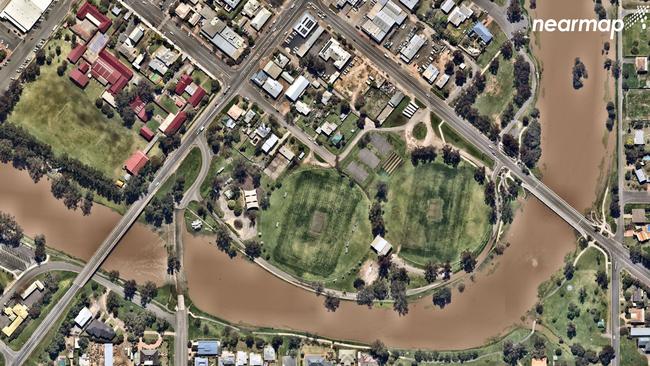
Wagga Wagga
Meanwhile in Wagga Wagga has seen disastrous flooding with the Murrumbidgee River flowing into the town and peaking at 9.72 metres on Friday.
While the Murrumbidgee River didn’t reach the heights of flooding in 2012, peaking at 10.5 metres, more than 700 people were forced to spend a night away from their homes.
100 of those registered at the city’s evacuation centre.
Despite water receding in both towns, NSW SES have warned residents to be wary of further flooding is predicted later in the month.

Wagga sale and auction results, week ending April 26
See the latest auction and sales results in Wagga for last week.

‘Kindest heart’: 21yo aspiring teacher mourned after fatal crash
A young woman with the world at her feet and who had dreams of becoming a teacher is being remembered as having “the kindest heart” and being the “light in every room” after she was killed in a crash over Easter.