
Hunter New England Health District create maps showing the breakdown of coronavirus cases
Want to see where the most infections of COVID-19 cases have occurred? Hunter New England Health District has created two maps to tell us where. Take a look.


Newcastle
Don't miss out on the headlines from Newcastle. Followed categories will be added to My News.
Hunter New England Health have created maps showing where COVID-19 cases have originated.
One map shows the breakdown of how many people have been infected in each local government area throughout the Hunter region.
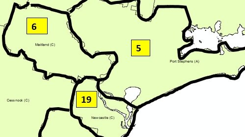

As of Thursday, Lake Macquarie had been the hardest hit with 24 cases, followed by 19 in Newcastle, six in Maitland, five in Port Stephens and three that are unknown.
It brought the total number of cases across the Hunter region to 57
Another map shows the number of cases broken down into three districts across the New England, Mid-Coast and Hunter Valley/Upper Hunter.
It shows 15 confirmed COVID-19 cases across the Hunter Valley/Upper Hunter. It equalled a total number of 103 cases
But as of Thursday afternoon, the total again rose, with 124 cases confirmed across the local health district.
Cases have also been broken down into likely source of infection:
Overseas acquired: 93
Locally acquired - contact of a confirmed case: 21
Locally acquired - contact not identified: 5
Under investigation: 5
The number continues to change every day.
All cases are in home isolation. Health staff have contacted close contacts
for self-isolation and will contact them every day for wellness check-ups.
Hunter New England Local Health District has opened COVID-19 screening
clinics at John Hunter, Maitland and Calvary Mater Hospitals.