
New mapping reveals where 13,153 homes, units could be built under NSW planned density overhaul
New mapping has revealed the full extent planned housing reforms that would allow medium density apartments to be added to residential streets near town centres and public transport hubs.

North Shore
Don't miss out on the headlines from North Shore. Followed categories will be added to My News.
Residential streets across a north shore council area could be transformed with up to 13,000 new medium density homes and duplexes as part of contentious State Government’s housing density reforms.
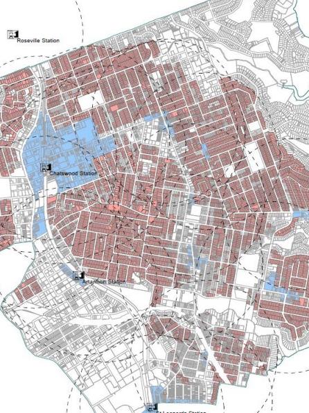
New mapping released by Willoughby Council has revealed the full extent of NSW Government planned density changes that would allow multi storey apartment buildings added to residential streets near town centres and public transport hubs.
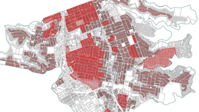
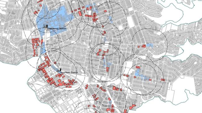
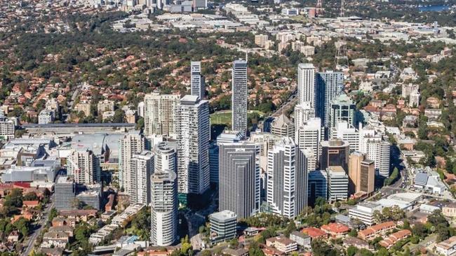
The modelling shows huge sections of the local government area would be subject to the proposed planning changes including parts of Chatswood, St Leonards, Artarmon, Northbridge and Naremburn.
The council has already experienced significant high rise development and population growth in recent years including in suburbs such as Chatswood and St Leonards.
But mapping by the council shows more streets could accommodate even further population growth as part of the NSW Government’s current drive to add 377,000 new homes across the state by 2029.
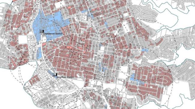
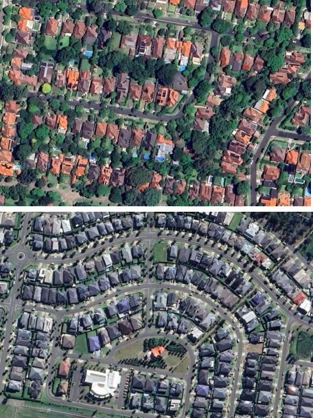
Under the planning changes, buildings up to 21m tall – or about the size of a six storey building – would be permitted within 400m of areas defined as ‘local centres’ and buildings up to 16m – or about the size of four storey building – would be permitted in areas up to 800m walking distance.
The modelling released by Willoughby Council has revealed the density reforms could result in up to 13,153 new buildings on existing blocks if the reforms are approved in their current form.
This includes up to 2631 multi storey dwellings, 1754 terraces and up to 6137 dual occupancy buildings.
The modelling shows that if the reforms have 15-30 per cent take-up rate, the reforms would result in an additional 2380 to 4760 dwellings.
In a draft submission to the Department of Planning, the council says the reforms lack vital detail about infrastructure such as schools that would be required for the predicted population surge.
Willoughby Council believes a ‘Future Infrastructure Fund’ should be set up to capture funding from a portion of the increased land values which could be allocated to infrastructure projects where development occurs.
”Greater clarity is also required as to how the proposed changes will be implemented so that councils and the community can accurately and confidently understand and respond to the proposed changes,” the draft submission adds.
Willoughby Council is also seeking clarification of what is considered a ‘local centre’ due to concerns that the smaller town centres such as Northbridge are not sufficiently connected or serviced by infrastructure to support the level of density outlined in the reforms.
The council warns the reforms are further “likely to result in significantly increased use of private vehicles and increased congestion” on local roads.
The reforms would also place pressure on the Chatswood Interchange public transport hub which is currently “operating at capacity with little room for physical growth”.
In a statement, the Department of Planning said new forms of residential development “represent a healthy evolution of the fabric for our suburbs.”
It is understood the department has received more than 6000 public submissions regarding the reforms ahead of final decision on the proposed changes, expected this year.
“There is overwhelming community support for additional housing to help tackle the current housing crisis in NSW and across Greater Sydney,” a department spokesman said.
“The changes will increase the capacity for more well-located homes, close to jobs and in places where people want to live.”
The modelling comes after similar mapping by North Sydney and Mosman Council shows the planning changes could see growth in almost half the local government areas, while in Ku-ring-gai the density drive would apply to large sections of the local government area including along the north shore rail line.
A community meeting in Ku-ring-gai recently heard multiple residents have already been approached by developers seeking to buy up properties in anticipation of the housing reforms.
Willoughby Council’s draft submission will be considered by councillors at a meeting next week before being forwarded to the Department of Planning.

Meet every player in the Netball NSW Premier League grand finals
NSW’s elite netball talents are on show this weekend in the grand finals of the Premier League. We take a look at every player set to take the court in the U23s and Open divisions.

Sydney Women’s Rugby: Meet 40+ stars on show in the finals
From international stars to rising young guns and those just happy to be alongside their besties, the Sydney Women’s Rugby finals has everyone covered. 40+ talents from all four divisions.