
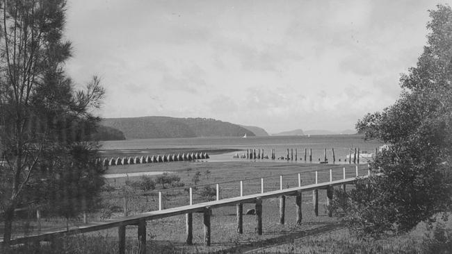
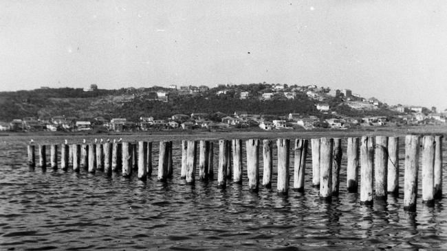
Timber piles at Dee Why are relics of wartime defences on the northern beaches
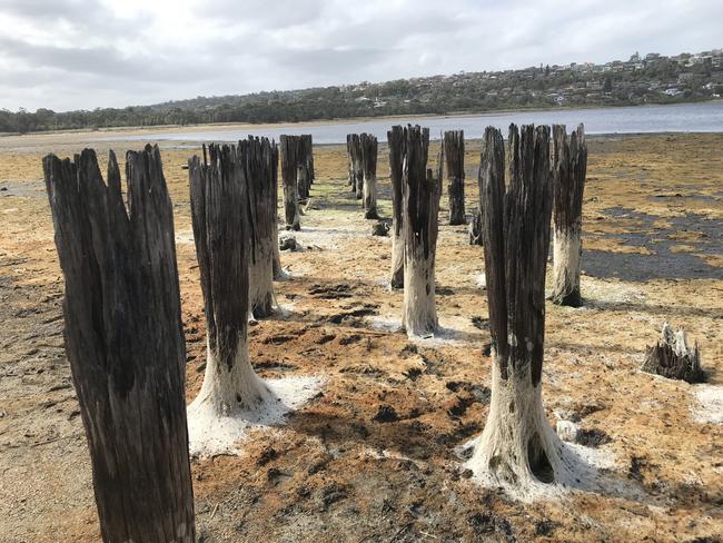
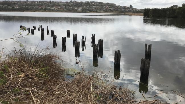
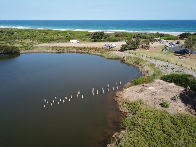
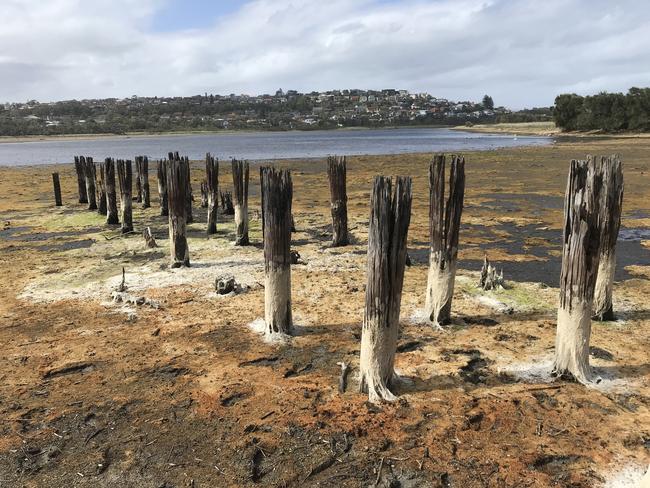
In the south-eastern corner of Dee Why Lagoon stand 28 decaying timber reminders of a time when Australia was at war and the fear of invasion from the sea was real.

Manly
Don't miss out on the headlines from Manly. Followed categories will be added to My News.
In the south-eastern corner of Dee Why Lagoon stand 28 decaying timber reminders of a time when Australia was at war and the fear of invasion from the sea was real.
The timber piles were driven into the bed of Dee Why Lagoon to prevent tanks skirting an anti-tank trench that was excavated between the lagoon and the beachfront.
But if one local resident had had his way in 1944, the timbers piles would have ended up as firewood.
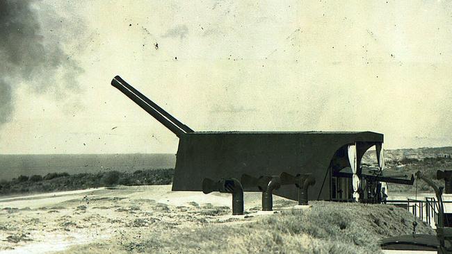
Throughout the 1920s and 1930s, military the authorities planned for the defence of major Australian ports, particularly Sydney, and by 1936 twin 9.2-inch batteries had been built at North Head and Cape Banks, supported by 6-inch batteries at Georges Head and Middle Head.
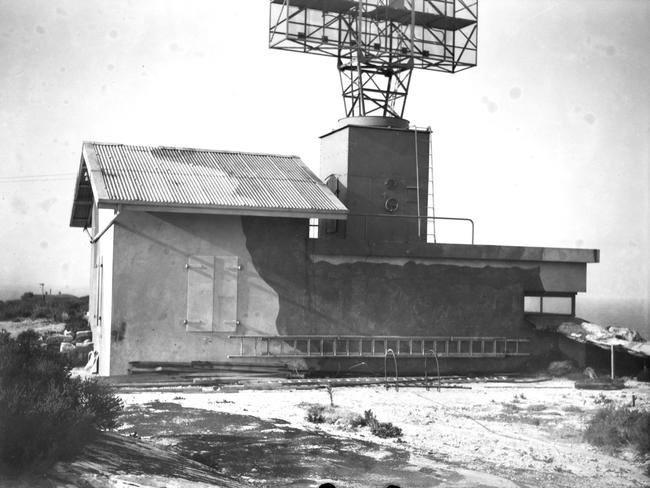
At the same time, plans were afoot to build other defences along the coastline, including two 4.7-inch guns and searchlights at West Head to guard Broken Bay and Pittwater, an anti-aircraft battery and searchlights at North Head, and radar stations at North Head, Beacon Hill and Collaroy Plateau.
Fears an invasion from the sea, especially on Sydney’s northern beaches, led to the development of a defence plan for the area, the purpose of which was to prevent an enemy landing on one of the beaches and then using Pittwater Rd and Condamine St to move closer to Sydney.
According to a 1940 Defence Plan now held by the National Archives of Australia: “The coast from Narrabeen to North Head offers many possibilities for enemy landings – there are actually eight beaches, all of which are suitable for land troops in large numbers, from shallow draught tenders or similar craft.
“The contour of the coast in this sector allows for landings in any weather on some beaches (Long Reef in particularly).
“A further point which would influence an enemy in selecting this as a landing sector is the fact there is a first-class concrete road running parallel to the beaches from Narrabeen to Manly.
“The Defence Plan is to deny any landings on any of the beaches in this sector and to provide infantry close defence for the Fortress Area.”
The front was divided into four sectors:
Northern sector – Narrabeen Head to Long Reef
Central sector – Long Reef to Harbord Head
Southern sector – Harbord Head to Shelly Beach
North Head Fortress Area – the whole of North Head.
Dee Why was in the Central sector, to which was allotted five Vickers machine guns and five light automatic guns, while four anti-tank guns were allotted to the entire Narrabeen to North Head area.
The outbreak of war in Europe in September 1939 hastened defence planning and construction in Australia but the bombing of Pearl Harbor in December 1941 and the entry of Japan into the war sent preparations into overdrive.
Within 16 days of Pearl Harbor, work began in earnest at ground level to prevent an enemy landing on the northern beaches.
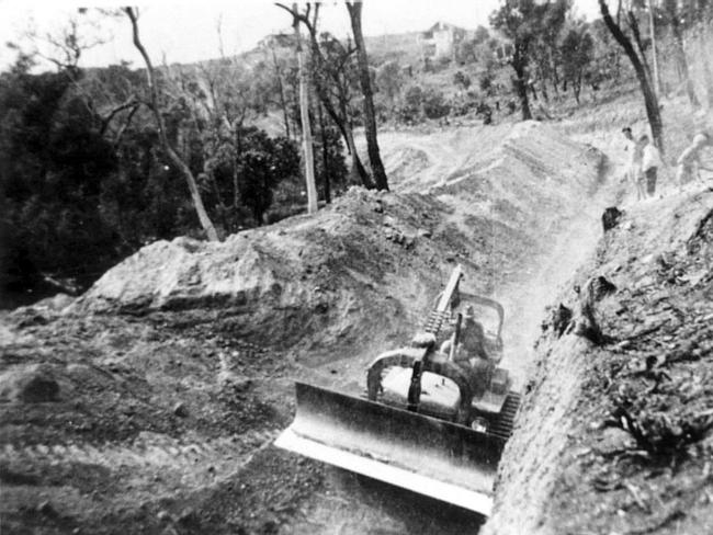
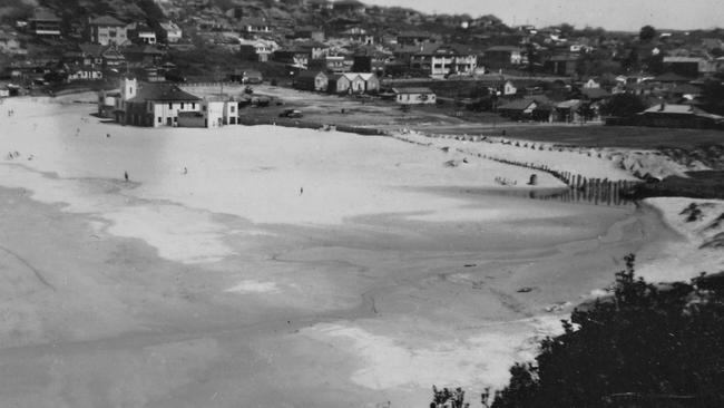
The most vulnerable spot on the coast between Narrabeen Head and North Head for landing craft was the long sand dune between Dee Why Lagoon and the Pacific Ocean, so it had be flattened.
The area levelled included the sand dune between the lagoon and the ocean, the dunes north-east of the mouth of the lagoon for a distance of about 600m and the dunes north and north-west of the mouth of the lagoon.
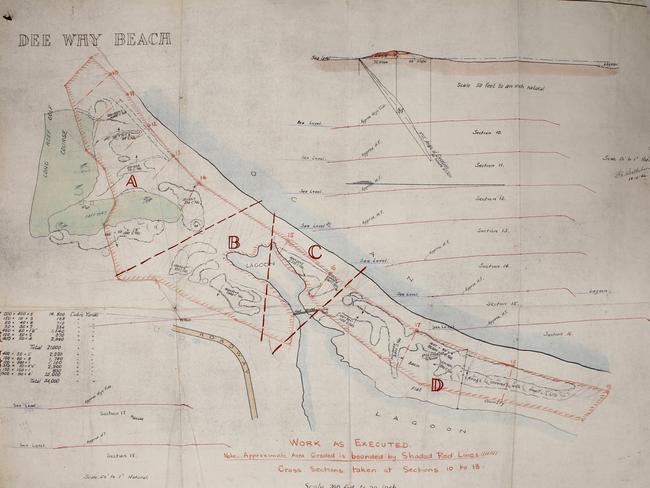
It was estimated the quantity of sand to be moved would be about 55,000 cubic yards (42,050 cubic metres) and that the work would cost up to £5000.
Work began on December 23, 1941, and picked up pace as more earthmoving machines were brought in.
The machines used to level the sand dunes were operated seven days a week, while the men worked during daylight hours, six days a week.
Up to seven bulldozers and tractors were working at one time, including Caterpillar and Cletrac bulldozers, some with scoops attached.
Some of the machines and the personnel used to operate them came from as far afield as Deniliquin in the Riverina and with Pearl Harbor so fresh in everyone’s minds, the work was deemed so urgent that all holiday leave for machine operators was cancelled.
The work was to have been carried out by the Public Works Department but was instead carried out by personnel from the Water Conservation and Irrigation Commission.
The work to level the dunes was undertaken with such speed that 15 per cent of the work had been completed by January 1, 1942, 33 per cent had been completed by January 9, 60 per cent had been completed by January 16 and all of it had been completed by January 29, 1942.
By the end of the work, it was estimated that the amount of sand that had been moved was 100,000 cubic yards (76,455 cubic metres).
The final cost of the work was £4624.
Levelling the sand dunes north-east of the mouth of Dee Why Lagoon and on the southern side of Long Reef golf course not only made the area more defensible in case of invasion, it also assisted 9 Infantry Brigade, which established a field firing range that traversed the mouth of the lagoon in the south and the south-eastern end of Fishermans Beach in the north.
9 Infantry Brigade used light machine guns, medium machines guns, and 3-inch mortars.
Once the dunes had been levelled, the next phase of the defence of Dee Why could begin – the excavation of an anti-tank trench between the lagoon and the ocean and the driving of timber piles in the south-eastern corner of Dee Why Lagoon to prevent enemy tanks or other vehicles skirting around the anti-tank trench.
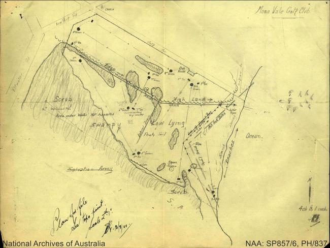
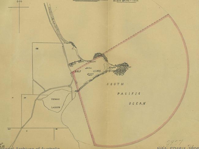
The anti-tank trench at Dee Why was one of three excavated on the northern beaches, the others being on the eastern side of Mona Vale golf course and across the Pittwater peninsula from Bungan Beach to Winji Jimmi Bay.
Rather than the anti-tank trench at Dee Why being dug at 90 degrees to the shoreline of the beach, as would be expected, it was dug at 45 degrees to the shoreline from the northern end of the stepped seawall at Dee Why Beach to the south-eastern corner of the lagoon.
At the time, Dee Why surf club was immediately behind the northern end of the stepped seawall, about 80m south of its current location.
Prior to the anti-tank trench being excavated, the sand in front of the seawall was removed to make it difficult for any vehicle to climb the seawall’s steps.
The Department of Public Works was to be the constructing authority of the trench and the work was to be carried out by the Metropolitan Water, Sewage and Drainage Board.
The anti-tank trench at Dee Why was 240m long and both sides of the V-shaped trench were revetted with timber to prevent sand falling into it.
The timber cost £243.
The bottom of the trench was above sea level so it did not flood.
Initially, it was planned to have a double row of reinforced concrete tetrahedrons placed from the end of the trench into Dee Why Lagoon to a point where the minimum depth of water was 5ft (1.5m) but by June 1942 the plan had been altered so that the concrete tetrahedrons were to be replaced by a triple row of timber piles driven into the bed of the lagoon.
Timber piles were also used as tank obstacles at Bayview and across the mouth of Freshwater Beach.
They were also used at Port Kembla, where C. R. McKenzie (Drummoyne) Pty Ltd.
McKenzie was contracted to drive about 1000 20ft (60m) piles for two anti-tank obstacles at Windang and Mullet Creek.
The hardwood piles at Port Kembla were 12 inches (30cm) in diameter and were supplied by the Forestry Commission of NSW.
The minimum payment per pile was to be £2.10.0.
The piles used at Dee Why Lagoon would have been identical to those used at Port Kembla.
Originally more than 50 timber piles were driven into the bed of the lagoon.
The Metropolitan Water, Sewage and Drainage Board estimated the cost of excavating the anti-tank trench and installing the timber piles at £2820 but the final cost was £2364.
Other defence works at Dee Why included barbed wire entanglements on the beachfront from Dee Why to Long Reef, the emplacement of a machine-gun nest above the rock pool and the demolition of a band rotunda on the reserve behind the beach and of a footbridge across the lagoon near its mouth.
The defence works at Dee Why were initially manned by members of 7 Garrison Battalion and later by 18 Garrison Battalion after 7 Garrison Battalion was deployed to south-east Queensland.
Various properties in Dee Why, Narraweena and Cromer were hired by the army to house members of the garrison battalions while they were stationed at Dee Why, including Glendowie Hall at the southern end of The Strand, while a shop in The Strand was used as the local headquarters.
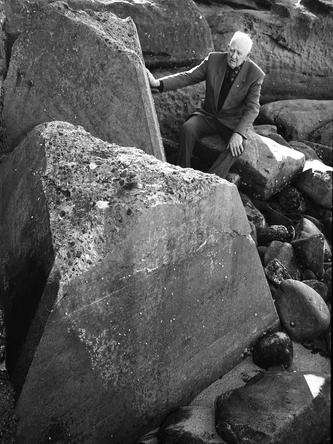
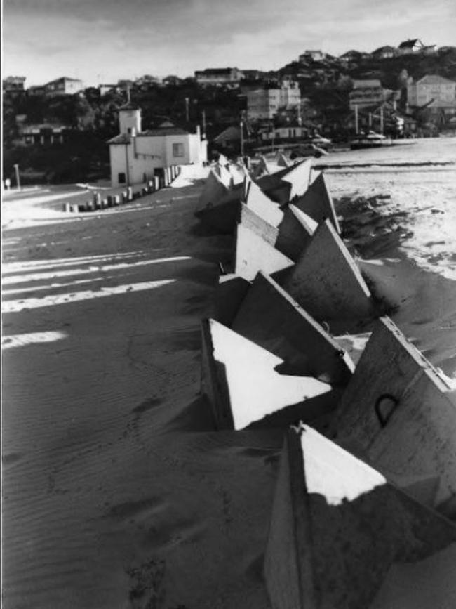
Anti-tank obstacles in the form of reinforced concrete tetrahedrons were also installed at several other locations, including at Bayview, Freshwater Beach and Shelly Beach, and miles of barbed-wire entanglements, sandbagged foxholes, trenches and machinegun emplacements were established along the ocean beaches and in Pittwater.
Anti-submarine nets were erected across the mouth of Pittwater and across the entrance to Sydney Harbour.
The biggest scare for locals was when three Japanese midget submarines entered the harbour on the night of May 31/June 1, 1942.
Only one of the submarines fired torpedoes, one of which hit the sea wall at Garden Island and sank a ferry being used to accommodate sailors, 21 of whom were killed.
But by the time the anti-tank trench at Dee Why had been finished in mid-1942, it was no longer needed, although it may have taken the military authorities a while to realise that.
The Battle of the Coral Sea from May 4-8, 1942 forced Japan to abandon its planned seaborne invasion of New Guinea at Port Moresby and the Battle of Midway from June 4-7, 1942 was a decisive defeat for the Japanese Navy and effectively ended any chance of Japan being able to mount an invasion of Australia.
By 1943, with the threat of invasion over, local councils and the army began discussions about the removal of coastal defences.
In October 1943, the army agreed that £240 be paid to Warringah Council as compensation for damage done to the seawall, stormwater channel, promenade, paving and surf pavilion Dee Why Beach and the demolition of bandstand on Dee Why Beach Reserve.
In July 1944, Dee Why man Edward Kneebone asked the council if he could remove the timber piles in the lagoon for firewood.
The council told him that while the piles were on council property, they belonged the army so it could not grant his request.
The council was given permission by the army to remove the timber piles later in 1944 but it was loath to take on any legal liability associated with their removals, to there they stayed.
At the end of the war most of the coastal defences along the northern beaches were removed or filled in, although some of the concrete anti-tank tetrahedrons can still be seen around the northern beaches and numerous installations at North Head and West Head remain.
The two concrete tetrahedrons in the carpark at Collaroy opposite the end of Jenkins St are not leftovers from the war.
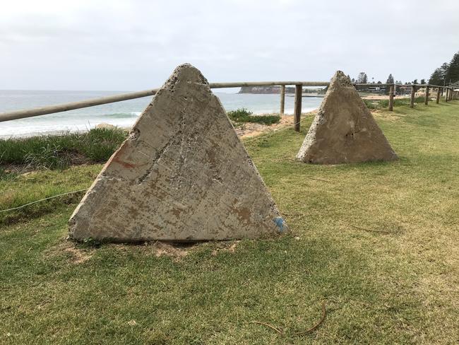
They were two of dozens of concrete tetrahedrons that were placed on the beach in February 1946 to prevent further erosion of the beachfront following storms in June 1945 and were uncovered while the seawall opposite the end of Jenkins St was being constructed in 2019.
The timber piles in the south-eastern corner of Dee Why Lagoon are among the few reminders of the war on the northern beaches not made of concrete but they won’t last forever.

Nurse strike for better wages and conditions called off
A planned strike by nurses and midwives across eight hospitals, including the Northern Beaches, was called off on Friday morning after the Fair Work Commission stepped in.
‘Knockdown’ semi sells for record-breaking $10m+
A ‘knockdown’ semi has sold for more than $10m — smashing the record by more than $2m — to a buyer who fell in love with the view.