
Beaches Link: EIS reveals details of controversial toll tunnel to northern beaches
The details of a proposed underground toll road that has divided opinion on Sydney’s northern beaches and north shore have been revealed. SEE VIDEO EXPLAINER.
Manly
Don't miss out on the headlines from Manly. Followed categories will be added to My News.
Details of the proposed Beaches Link underground toll road into the northern beaches have been revealed with the release of the environmental impact statement into the controversial $8 billion project released on Wednesday morning.
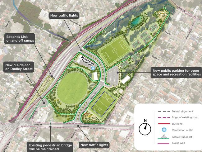
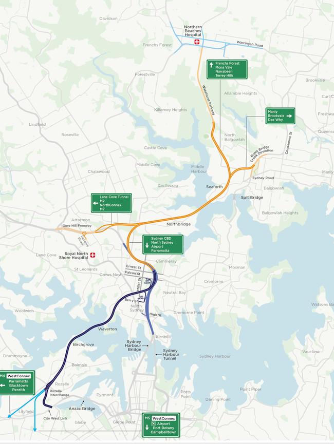
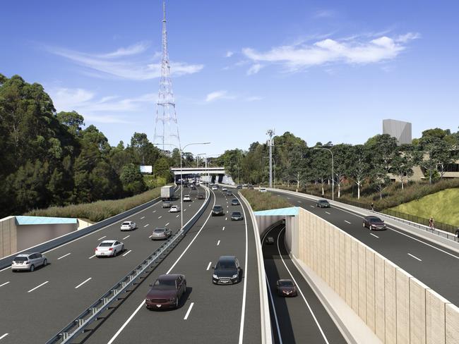
The NSW Government has confirmed the twin tunnels, stretching from Seaforth and Balgowlah, under Middle Harbour to the Warringah and Gore Hill freeways at Cammeray and Artarmon, will have three lanes each way.
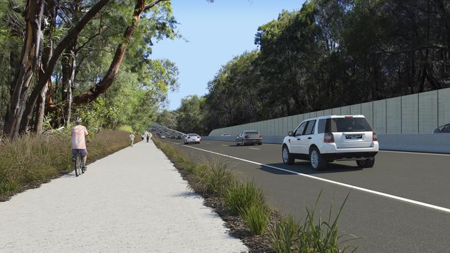
As part of the project, Wakehurst Parkway will be widened from one lane to two in each direction between Seaforth and Frenchs Forest.
Premier Gladys Berejiklian said the Link — that will be 108m below the surface — will cut congestion on the Spit Bridge, Military Rd and Roseville Bridge and allow motorists to bypass 19 sets of traffic lights through The Spit, Mosman and Neutral Bay.
In a statement released this morning Ms Berejiklian said travel times between the northern beaches and the city, the airport and Macquarie Park will be slashed. The Beaches Link will connect with the Western Harbour Tunnel, through to Rozelle.
“Residents in Neutral Bay, Mosman and Cremorne will experience less congestion and noise, with traffic volumes expected to reduce by around a third along Spit Rd,” she said.
“The Western Harbour Tunnel and Beaches Link program is expected to support around 15,000 full-time jobs.”
The study reveals that for the Beaches Link component of the project, 41 properties would require permanent acquisition and five properties would require temporary lease. In order to build the Gore Hill Freeway Connection, five properties would be permanently acquired and two properties would be temporarily leased.
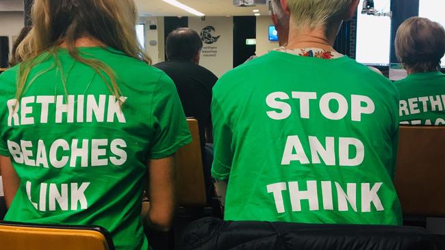
Critics of the underground link have said the twin tunnels will only attract more vehicles on to roads on the northern beaches.
There have also been concerns about unfiltered exhaust stacks near Balgowlah and Seaforth.
However, within the study is a report by the independent NSW Chief Scientist and Engineer who found that “emissions from well-designed road tunnels cause a negligible change to surrounding air quality, and as such, there is little to no health benefit for surrounding communities in installing filtration and air-treatment systems in such tunnels”.
Nerissa Levy, from the commujity group Beaches Tunnel How It Impacts Yiu (Save Balgowlh) said the EIS suggested that unfiltered exhaust stack was moved closer to Balgowlah Boys High and Seaforth Public schools.
“The EIS has a lot of info to read and fancy graphics, but unfortunately they still haven’t listened to the community on the key impacts,” Ms Levy posted on Facebook.
“There are still unfiltered stacks next to homes and schools, massive distruption from construction, overall loss of green space, and a complete lack of any business case that demonstrates any benefit to the community.”
Ms levy also pointed out that the proposed plan showed that the Burny Bridge Creek Deviation would not be 12 lanes at one section and that the entrance to the Link at Balgowlah had “moved south by about 150m, taking over the space from Dudley St houses”
Zali Steggall MP, Independent for Warringah, said while she welcomed the announcement from the state government in relation to the tunnel because the northern beaches has been desperately in need of better traffic solutions, she was concerned about the exhaust stacks.
“I am concerned however that the report says no filtration is needed for the tunnel,” she said.
“This is purely a cost cutting decision that is short sighted and does not account for the pollution that will be caused by the tunnel.
“Just as 20 years ago, governments thought nothing of pumping unfiltered sewerage into our oceans, now, the government thinks nothing of unfiltered stacks polluting the air for our local community.”
Meanwhile, while most of the construction for the Beaches Link site would be carried out between 7am to 6pm Monday to Friday and between 8am and 1pm on Saturdays, tunnelling would continue 24/7.
Purpose-built acoustic sheds would be designed to minimise construction noise on the local community, which includes a high school and a primary school.
But construction of the Gore Hill Freeway Connection surface road works, and surface works associated with the tunnel connections at Burnt Bridge Creek Deviation at Balgowlah and Wakehurst Parkway at Seaforth/Killarney Heights would require extensive out of hours work, to minimise traffic disruptions and maintain safety for workers and road users and the public.
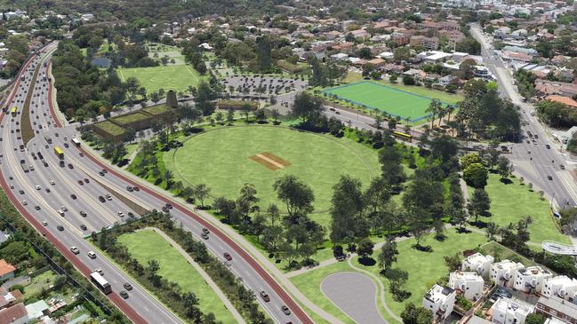
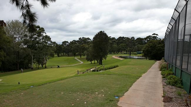
The Balgowlah Golf Course will be resumed to allow tunnel construction, but 90 per cent of that land will be returned as improved community open space.
And other areas that will suffer temporary loss of space during construction include environmentally-sensitive areas such as Manly Dam, Bantry Bay Reserve, Flat Rock Reserve and Spit West Reserve.
The Balgowlah Residents Group have described the Link as an “ideological white elephant” and a “ politically motivated vanity project that will not fix transport on the northern beaches”.
“As a local community group, we have gained support from residents realising the project would not significantly improve travel times in the longer term, and only create further congestion on local roads with limited public transport options,” the Group said in a letter to MPs.
“Going ahead with the project would also mean significant environmental destruction to some of our local waterways and green spaces, and would result in no future funding to actually improve transport in the area.”
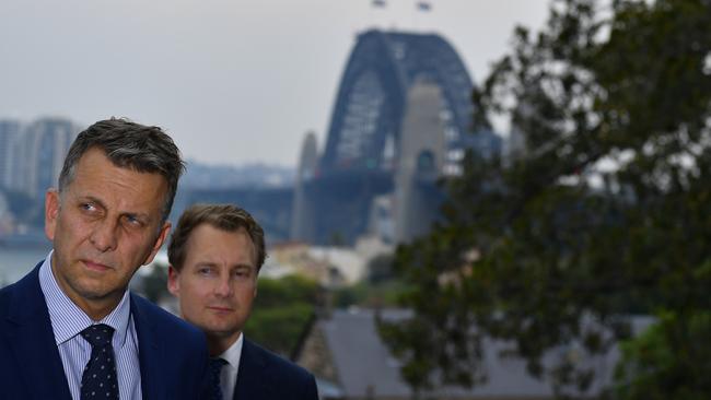
Transport Minister Andrew Constance said Beaches Link would provide the chance for new express bus services to St Leonards, Macquarie Park, North Sydney and the Sydney CBD as well as to the interchange with the new Sydney Metro train line at North Sydney.
“We’re also planning more than five kilometres of new cycle and pedestrian pathways, including links to the Northern Beaches Hospital precinct.”
WHAT WILL IT MEAN FOR THE LOWER NORTH SHORE
The full impacts of Sydney’s next motorway tunnel have been revealed with new ventilation facilities, loss of parkland and major traffic changes earmarked for suburbs across the lower north shore.
The tunnel will link the Warringah Fwy at Cammeray and the Gore Hill Fwy in Artarmon to Balgowlah and Killarney Heights.
One of the most challenging aspects of the project will be the crossing of Middle Harbour which plans show will be built as twin “immersed tube tunnels” and will take more than three years to complete.
A raft of road modifications will also be made to link the tunnel with the existing road network including major traffic changes at the Gore Hill Fwy in Artarmon.
If approved construction is due to begin in 2023 and would be completed by 2028.
The North Shore Times has broken down aspects of the project, showing the impacts for local government areas including Willoughby, Mosman and North Sydney.
VENTILATION OUTLETS
Ventilation outlets have been earmarked for four locations along the tunnel route including at the Warringah Fwy in Cammeray, the Gore Hill Fwy in Artarmon and locations in Balgowlah and Killarney Heights.
In Artarmon, the ventilation facility would be at the eastern end of Cleg St, while in Cammeray the ventilation stack would be built north of the Western Harbour Tunnel ventilation outlet at the intersection of Ernest St and the Warringah Fwy.
Documents show the ventilation facilities for the project would not be filtered - despite potential impacts on air quality listed as a leading concern among residents during early feedback on the project.
Transport for NSW said the project had been designed to meet in-tunnel criteria and ambient air quality goals.
“The inclusion of filtration would result in no material change in air quality in the surrounding community when compared to the current project ventilation system and outlet design,” the plans stated.
CONSTRUCTION
Construction support sites will be located at various locations along the route including at Flat Rock Reserve, Spit West Reserve and Cammeray Golf Course.
The temporarily support site at Spit West Reserve - measuring 26,000sqm of water area and 4500sqm of land area - would be used to support construction of the tunnel crossing at Middle Harbour that will involve partially fabricated concrete sections of the tunnel completed on site before being transported by tug boats and placed into their final position.
Two temporary cofferdams would also be constructed at each of the Middle Harbour crossing at Northbridge and Seaforth to connect the immersed tube tunnels to the land tunnels.
Contamination risks have been flagged during this aspect of the project due to potential disturbance of known contaminants in sediment which “are likely to be excavated and exposed” at Spit West Reserve and Middle Harbour.
The EIS shows there would be temporary impacts on maritime activity including partial closures of Middle Harbour for recreational, commercial and government users between Northbridge and Seaforth and adjacent to Spit West Reserve.
The project documents also show construction sites will be built at Flat Rock Reserve and Cammeray Golf Course to support excavation works. Both sites have previously been included for construction works on the Western Harbour Tunnel.
Another construction support site will be on Cleg St in Artarmon along with a new motorway control centre on the southern side of the Gore Hill Fwy in Artarmon.
A total of 41 properties would be permanently acquired for the project with a further five required under temporary leases.
In Artarmon, 12 commercial businesses would be permanently with maps showing the acquisitions would include the Freeway Hotel and Jax Tyres on Reserve Rd.
TRAFFIC IMPACTS
Traffic modelling predicts the project will result in up to 580 construction vehicle movements each day at the Cammeray Golf Course construction site, along with 950 at Punch St in Artarmon and 900 movements at Flat Rock Drive, 440 movements at Spit West Reserve, 590 at Dickson Ave in Artarmon and 155 at Barton Rd in Artarmon.
The project would involve reconfiguring the Gore Hill Freeway in Artarmon including constructing new off-ramps to link the existing road network to the tunnel.
Reserve Rd between the Gore Hill Fwy and Dickson Ave would be widened to accommodate off ramps and would include adding an extra northbound lane to the Reserve Rd bridge.
There would be new traffic lights at the intersection of Dickson Ave and Pacific Hwy to accommodate extra traffic.
NOISE AND VIBRATION
The proposed tunnel would pass under suburbs including Willoughby, Naremburn, Northbridge with tunnelling activities carried out 24 hours a day, seven days a week.
The EIS stated tunnelling works would involve purpose-built acoustic sheds “to minimise construction noise impacts for the local community”.
The majority of surface construction work would be limited to 7am and 6pm on weekdays and from 8am and 1pm on Saturdays
Up to 440 buildings are predicted to experience construction vibration levels above the human comfort criteria from rock-hammers during tunnelling.
Noise impacts are also predicted for education facilities including Artarmon and Anzac Park Public Schools as well as childcare centres including the Butterflies Early Learning Childcare Centre, Willoughby/Lane Cove Family Day Care, Innovative Early Learning Artarmon and KU Cammeray Preschool.
CONGESTION
The State Government said a leading benefit of the project would be reducing congestion on the region’s roads including Sydney Harbour Bridge, the Warringah Fwy and the Sydney Harbour Tunnel.
Modelling predicts the journey from North Sydney to Balgowlah would be reduced to 15 minutes - a saving of 28 minutes - while the journey from Rozelle to Frenchs Forest would take 24 minutes - a saving of 54 minutes
The modelling shows peak period traffic demand on Military Rd and Spit Rd would also decrease by up to 11 per cent and 33 per cent respectively.
Peak period traffic on Mona Vale Rd is also estimated to decrease by up to eight per cent while Eastern Valley Way is predicted to have its traffic drop by up to 40 per cent.
The plans stated the tunnel would also reduce “rat-running” on local streets including Ourimbah Rd through suburbs including Mosman and Neutral Bay.
The modelling predicts the reliability of the B-Line would also be improved by reducing congestion on the Spit Bridge and Military Rd and has flagged the potential opportunity for a new “express bus services” linking the Northern Beaches to North Sydney, the CBD, Macquarie Park and St Leonards via the new motorway network.
The EIS will be on public exhibition until March 1, 2021.
To read the EIS: https://www.planningportal.nsw.gov.au/major-projects/project/10456


‘Wowzee, he’s quick’: Rugby’s future on show in U14s County v City
There’s a son of a gun who couldn’t be more different from his famous dad with a rugby IQ ‘off the charts’. U14 guns to watch at City v Country rugby this weekend.

Country rugby captain leading from front in City battle
He’s torn between league and union but this weekend this teens focus is 100 per cent on leading his side to a defence of the title they won at last years City v Country rugby event