
Hawkesbury floods: Nearmap before-and-after aerial imagery reveals damage and devastation
Heartbreaking before-and-after aerial imagery by Nearmap lays bare the cruel aftermath of yet another devastating flooding disaster. See the shocking photographs.
Hills Shire
Don't miss out on the headlines from Hills Shire. Followed categories will be added to My News.
Shocking before-and-after aerial imagery lays bare the full extent of the most recent floods to hit Hawkesbury and north west Sydney — with many residents and businesses left once again to clean up the wreckage.
Thousands evacuated and lost precious belongings and livestock as the river rose, flood banks broke and dams overflowed for the third time in just 18 months.
Hawkesbury City mayor Patrick Conolly said it was difficult to put into words just how difficult these recent floods have been for residents.
“It is heartbreaking for our community to have to go through the fifth major flood in just over two years,” Mayor Conolly said. “Many of our towns were still in the recovery process from the March 2021 and March 2022 floods when the July flood occurred.
“It isn’t just roads and infrastructure that have been badly damaged. It is homes and livelihoods.”
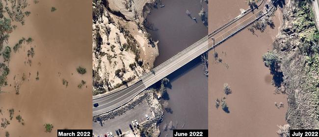
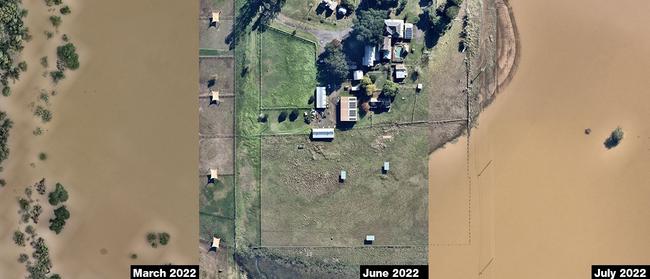
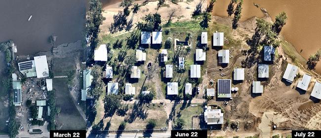
Nearmap captures aerial imagery following every major natural disaster in Australia.
Its leading aerial imagery, location intelligence and geospatial tools provide critical access to on-the-ground information following natural disasters, times when so often ground access is limited, and inspection resources are stretched.
See Nearmap’s incredible aerial imagery of the floods below.


Join the conversation

100 point demolition, Fittler scores, trifectas galore in crazy 1st Colts round
One team piled on an extraordinary 100 points, numerous players scored trifectas and the son of a footy gun scored his first try in a crazy round of Sydney 1st Colts Rugby. Rd 11 stars, result wrap
Read more

‘Life or death’: Alarm over city judges ruling on bush bail cases
A plan to have city magistrates remotely dealing with bail applications from the country has raised alarm about fairness and the possibility of recidivist offenders getting out more often.
Read more