
12,000 homes destroyed, 90,000 people displaced if worst-ever Hawkesbury Nepean flood was repeated
A NSW Government study has found thousands of people would be left without homes if Sydney’s worst-ever flood was to repeat itself today. SEE THE VIDEO


- Flood plan reveals victims to be housed at Olympic Park during natural disasters
- Transforming Western Sydney: $1.1 billion of development
- FEATURE: Western Sydney faces worst travel, urban heat
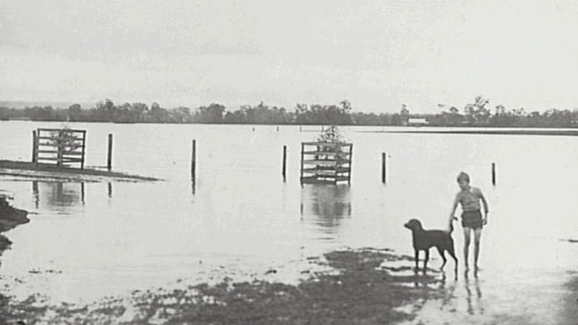
Tens of thousands of homes would be inundated and more than 90,000 people evacuated across western Sydney, if the largest flood on record — which saw waters rise up to 21m — was to repeat itself today.
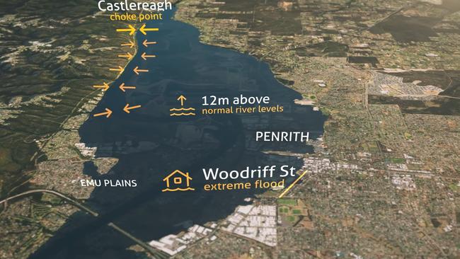
The NSW State Emergency Services recently released the latest flood mapping for the Nepean and Hawkesbury Valley, which uncovered suburbs including Wallacia, Penrith, Emu Plains and Castlereagh on the banks of the Nepean River could be flooded as waters rise between 12 and 21m in height.
While Hawkesbury River suburbs such as Richmond, Windsor, McGraths Hill, Bligh Park, as well as Riverstone, Schofields and Marsden Park would see flooding up to 10m above normal river levels.
The NSW Government’s Hawkesbury-Nepean Valley Regional Flood Study recently evaluated the river catchments that would contribute to a possible high-risk flood, identifying The Warragamba and Nepean Rivers as a major tributaries.
“The catchment above Warragamba Dam makes up around 80 per cent of the total catchment to Penrith and 70 per cent to Windsor,” the latest study said.
“Therefore it has a major influence on flooding in the valley, contributing the majority
of flows in the largest floods.

“If the storage level behind Warragamba Dam is very low, it can help hold back the inflows during floods. However, in large rainfall events, the dam can fill and spill quickly.”
Other water sources included the Grose River, South Creek, Colo River and Macdonald River.
An expert review found floodwaters in a one in 500 chance per year flood could result in floodwaters stretching “up to 20kms wide in the Richmond and Windsor floodplain”.
“Since records began in the 1790s, there have been about 130 moderate to major floods in
the valley,” the report found.
“The largest flood in living memory was in November 1961, when the water reached
14.5 metres above normal river height at Windsor.
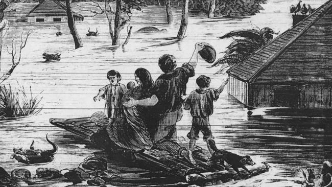
“The largest flood on record was in 1867, and reached 19 metres above normal river height at
Windsor — the floodwaters from the river nearly reached the corner of High and Woodriff Streets in Penrith, and most of Emu Plains was under water.”
NSW Emergency Services Minister, David Elliott said it was important to ensure emergency services and the community were prepared for a flood event.
“It’s important to have the best possible information on the nature and scale of potential flooding,” Mr Elliott said in response to the latest flood study.
“This new information and mapping will support our emergency management and evacuation planning for the valley.
“I encourage all the communities in this area to know their flood risk, act promptly if asked to evacuate and listen to safety messages from emergency services.”

The new study comes just weeks after Mr Elliott revealed thousands of flood victims would be relocated to Sydney Olympic Park under a mass care facility plan.
However, GIVE A DAM campaign manager, Harry Burkitt, refuted the claims by the NSW Government and NSW SES.
“It is a very sad day when an organisation that has served our community for so long is used as a political instrument of government,” he said.
“Be it at the behest of the SES or other more discrete actors, the campaign which SES are running on floods is one of fear and factually dubious claims.”
The defiance to the latest findings come as the campaign held a public meeting alongside Blue Mountains Mayor, Mark Greenhill, Wollondilly Mayor, Matt Deeth, and Traditional Aboriginal Owners.
The public meeting called on the NSW Government to acknowledge concerns around the Warragamba Dam raising assessment process and the lack of time they have been given to review the 2000-page Indigenous Cultural Heritage assessment.
Western Sydney Minister Stuart Ayres said The Hawkesbury-Nepean is a high risk floodplain.
“Raising the dam wall is key part of the strategy to reduce the existing risk to life and property on the floodplain,” he said.
“The final decision to raise the wall has not yet been taken and will only take place after financial, environment and cultural assessments have concluded.”

From City v County to Aussie rugby jersey! Teen’s story inspiring
Last year a teenager made his first NSW country team, played his heart out and is now inspiring other young guns from the bush as a rising star of rugby.

State of play! Australia’s best schoolboy rugby players revealed
The Australian Schools rugby championships threw up a clear winner in the battle between NSW and Queensland’s rising stars. Top players from every team and award winners.