
Central west on flood watch with Bureau of Meteorology expecting heavy rainfall
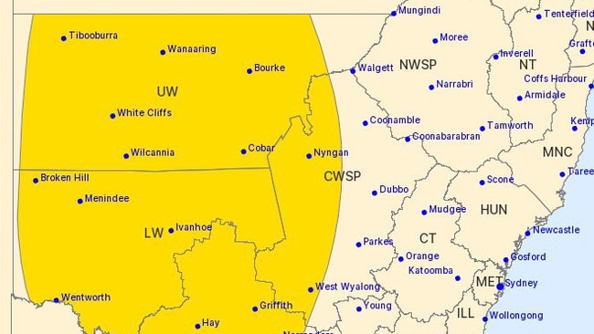
Major rivers in the central west and across the state are on flood watch with the Bureau of Meteorology anticipating up to 150 millimetres of rainfall. Full details here.

Dubbo News
Don't miss out on the headlines from Dubbo News. Followed categories will be added to My News.
The central west is on high alert with a rainfall forecast of up to 150 millimetres after residents have already copped flash flooding in the last fortnight.
The Bureau of Meteorology is anticipating “three rounds of rain” throughout the week, senior meteorologist Dean Narramore revealed.
“One today [and] tomorrow, another one Thursday night into Friday in NSW, and potentially even a heavier one Saturday through Sunday,” Mr Narramore told the ABC on Wednesday morning.
.@BOM_au says almost every river on and west of the ranges in NSW are under flood watch as three rounds of heavy rain move through this week.
— News Breakfast (@BreakfastNews) October 4, 2022
Senior meteorologist Dean Narramore says eight or nine rivers could see major flooding into the weekend. pic.twitter.com/fLVKmTv3AK
“Almost every river on and west of the ranges in NSW is also on a flood watch.”
Mr Narramore pointed towards the areas of “particular concern” given an expectation of 50 to 100 millimetres of “isolated falls” across the state and 150 millimetres in “inland parts”.
“Our rivers [in] the southern parts of the north west slopes and plains down into the central west slopes and plains of NSW,” Mr Narramore said.
“That includes the rivers like the Macquarie [and] the Namoi and also further down around the Lachlan and the Bogan as well, we’ve already seen moderate to major flooding on these rivers.
“And additional rainfall is likely to lead to renewed river level rises, at least into moderate if not major flooding.
“Around eight or nine rivers in NSW could see major flooding later this week into the weekend.”
With some towns and regional cities already having experienced major flooding in recent weeks, Mr Narramore said it’s “not good news” for residents in those communities as further rainfall will “increase the flood threat” heading into the weekend.
Incredible footage taken by Wellington local Matt Mara of the flooding over the weekend. pic.twitter.com/xrTjBQnDx3
— Aymon Bertah (@AymonBertah) September 19, 2022
The Central West State Emergency Service (SES) has warned residents to be careful for flash flooding.
“NSW river catchments remain saturated, with most major dams at or near capacity,” the SES said in a Facebook post.
“Any further rainfall is likely to lead to flash flooding developing very quickly resulting in road closures without warning.”
This has seen river levels in Warren rise to 8.88 metres on Tuesday morning with the BOM predicting the Macquarie River to peak near its major flood level at 9 metres at some point today.
“Residents and visitors in the Central West and Western Plains need to closely monitor weather conditions and make informed decisions based on their individual circumstances,” the SES said.


Revealed: The 60+ top cult heroes of local rugby league in NSW
They’re the players you love to have a beer with and would run through a brick wall for. We’ve scouted wide to find the best 60+ cult heroes of local rugby league in NSW.

Best of the best! Top 29 Aussie schools rugby sevens girls
They have speed, physical presence, silky skills and that special X factor. Australia’s top schoolgirl sevens players have been identified and the talent is extraordinary. TOP GUNS list