
The UN’s 1947 proposed partition of Palestine: 70-year-old map at heart of intractable Israel crisis
The deadly violence in Israel and Palestine may have been triggered just days ago but its origins go back decades – to a hand-drawn map.


The violence and death currently playing out across Palestine and Israel was ignited by a dispute in Jerusalem where Jewish settlers have laid claim to land inhabited by Arabs.
But the spark was lit more than 70 years ago, and in reality even further back than that.
And after all this time, the issue remains essentially the same: Who has the right to live where in the relatively small but densely populated Holy Land where faiths have intersected for millennia?
In 1947, after World War II, the United Nations tried to solve the issue by proposing to divide the land into two zones.
The plan was imperfect and was ultimately ignored. But the scars of that map remain in today’s brutal battles.
“The Israeli-Palestinian dispute is the perennial dilemma of the modern international legal system,” UK University of Newcastle international law expert Amy Maguire wrote in The Conversation.
“In 1947, the new UN resolved a Plan of Partition to create an Arab state and a Jewish state on Palestinian territory. The Jewish state – Israel – was declared in 1948. Palestine, though, remains a nascent state,” she said.
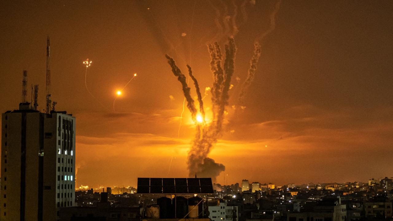
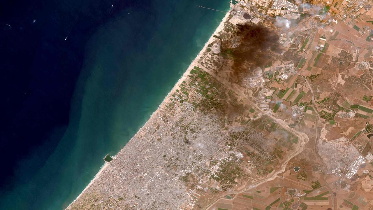
A dramatic escalation in the current conflict began on Friday morning when Israeli troops headed to the border of the Gaza Strip, a self-governing Palestinian territory.
The move followed days of missiles being fired by Hamas forces in Gaza with massive return fire from the Israeli Defence Force. And that followed ugly scenes in Jerusalem when Jewish settlers moved to force Arab families out of their home in the suburb of Sheikh Jarrah.
“The recent violence in the Old City of Jerusalem has spiralled into something bigger and more dangerous,” wrote Carlo Aldrovandi, an associate professor of international peace studies at Dublin’s Trinity College.
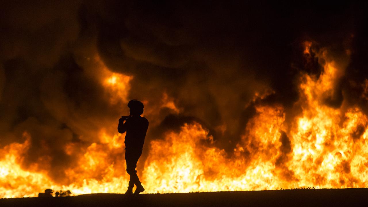
It’s been reported several residents of Israel have now died after rockets from Gaza penetrated Israel’s famed “iron dome” missile defence system. More than 100 have died in Gaza, including children, from Israeli rocket attacks.
RELATED: Why the Middle East has suddenly erupted
Map from 1947 sought to create two separate states
Some of the seeds for today’s anger was sown a century ago when Britain began its rule over what was then known as “Mandatory Palestine” in 1920. The heart of the Holy Land, it contained a wealth of different people and religions. English, Arabic and Hebrew were the territory’s three official languages but it was Arabs who were in the majority.
As early as 1917, Britain had promised to create a “national home” for the Jewish people within Palestine. But it also wanted to placate Arab desires in the hope of keeping Arab states on side in any looming wars.
By the late 1930s, the UK wanted out of the restive region. Unable to square the circle of how to divide up the territory that pleased everyone, Britain passed the responsibility to the UN.
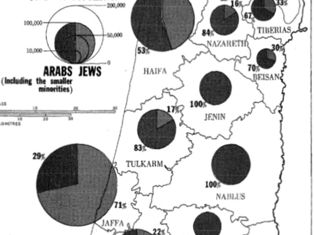
The organisation came up with UN General Assembly Resolution 181 (II) which proposed an Arab and a Jewish state, the latter deemed essential after the horrors inflicted on Jews by Nazi German in World War II. A map (below) showed how those two states would exist, separate but geographically intertwined.
The Jewish state would include a long but thin strip of coastal Palestine as well as the Negev desert and parts of the north. The Arab state would govern the Gaza Strip and an area including the West Bank and beyond.
Jerusalem, with its many different religious communities, would become an “international city” governed separately.
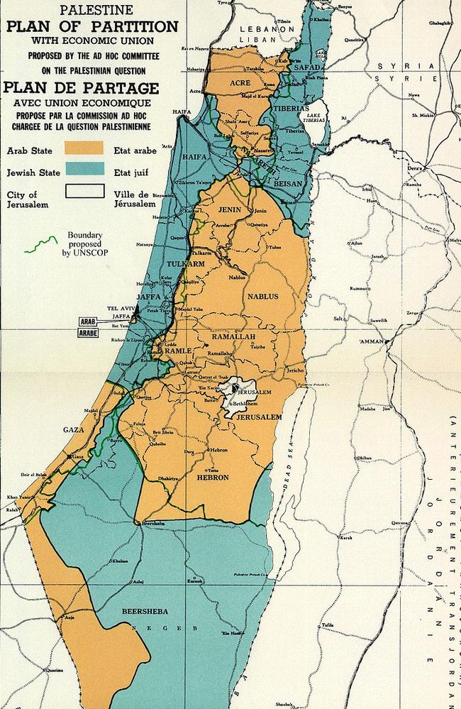
It was not a perfect plan. Gaza, which was 98 per cent Arab, was a no-brainer to be part of an Arab state. But areas in the Jewish zone were often more mixed. Almost a third of people in the Jaffa-Tel Aviv conurbation were Arab; most people in Jaffa itself were Arab. Yet to have a Jewish state in only Jewish majority areas would have led to a tiny, probably unsustainable, new nation.
On November 29, 1947, the UN passed the partition plan. However, most of Palestine’s Arab neighbours voted against the resolution, opposed to a Jewish homeland on land being permanently ceded to what would become Israel.
‘Mistake’ for Arab leaders to reject partition plan
In 2011, Palestinian Authority President Mahmoud Abbas said it had been a “mistake” to reject the plan which would have created a Palestinian state way back in the 1940s.
Almost immediately after the map was produced, a civil war broke out which led to 700,000 Palestinians either fleeing or being expelled from areas that were in the Jewish zone.
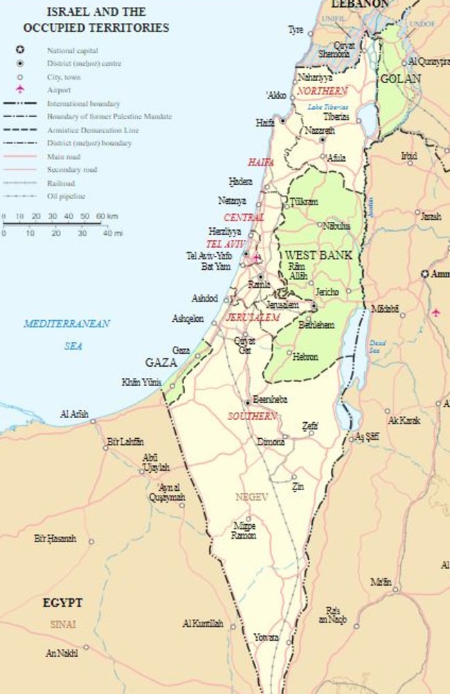
Britain’s by-then-tenuous hold on Mandatory Palestine was relinquished on May 15, 1948 with the state of Israel declared. The lack of agreement on what would become the state of Palestine meant Israel’s new rulers also didn’t explicitly declare where its frontier was.
What had been a civil war became a regional war. By March 1949, Israel had captured large tracts of land that had been in the proposed Arab zone as well as the western portion of Jerusalem.
Guerrilla groups backed by neighbouring Arab nations attacked Israel with the new nation fearful it would be invaded too. Subsequent wars, including the 1967 Six Day War, saw Israel capture more land including all of Jerusalem.
In 1990, Israel allowed some self-rule for Gaza and parts of the West Bank. However, Jewish settlements have been built on Arab lands, an act met with international criticism, and Israel’s West Bank barrier goes deep into Palestinian land.
“The wall does not follow the ‘Green Line’ considered essential for preserving territory to create a viable Palestinian state,” Prof Maguire said.
She continued: “85 per cent of the wall runs inside occupied Palestinian territory on the West Bank. Some Palestinian towns are almost entirely encircled by it.”
Modern political pressures pour fire on flame
Today, the torrid history of the divided land has mixed with more recent political concerns to create a flammable brew.
“This latest episode cannot be attributed to a single cause. It should rather be connected to a broader landscape of destabilising factors whose cumulative weight led to the current crisis after months of incubation,” Prof Aldrovandi wrote in The Conversation.
The Sheikh Jarrah crisis, where Jewish settlers believe they have a right to land currently lived in by Arab families, is just another example of the decades-old dispute about land ownership.
The weakness of the Israeli Government means it relies on support from hard-line Jewish groups who are in favour of settlements in Sheikh Jarrah.
RELATED: Australia and the US call for end to Gaza violence
“Israeli politics has reached a debilitating impasse after four general elections failed to establish a workable government. This has had severe ramifications for the handling of the crisis,” Prof Aldrovandi said.
Israeli Prime Minister Benjamin Netanyahu has only stayed on as leader due to support from hard-line parties and is facing corruption charges. It is unclear whether he will be able to cling to power after yet another inconclusive election held in March.
“On the Palestinian side, there is a power struggle taking place between Hamas and the president of the Palestinian Authority Mahmoud Abbas,” Prof Aldrovandi said.
“Hamas deliberately heightened tension with Israel by firing rockets from Gaza as a propaganda strategy to build political capital at Abbas’ expense.
“He, in turn, has postponed elections to the Palestinian Legislative Council for fear of losing ground against his Islamist rivals.”
Prof Aldrovandi said the violence now unfolding, the worst for years, had “potentially dire consequences for the stability of the whole region”.
The fault lines from a map drawn up in 1947 continue to ricochet through the Middle East, more than seven decades later.
Originally published as The UN’s 1947 proposed partition of Palestine: 70-year-old map at heart of intractable Israel crisis

