
South China Sea: Photos reveal secret underground base off Hainan Island
A cavern built into the side of a mountain had analysts perplexed. But then a satellite image captured a nuclear submarine slipping out.

World
Don't miss out on the headlines from World. Followed categories will be added to My News.
The moment a Chinese nuclear submarine slipped out of a secret underground base has been caught by satellite – laying bare the extent of China’s military ambitions.
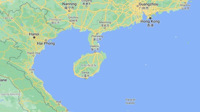
Just a few pixels on a commercial-grade Earth-observation satellite photograph, it portrays a piece of Hainan Island – a strategically significant 35,400sq km land mass off the south coast of China.
It’s the location of a major naval base – much of it concealed in a bunker built deep under a mountain peninsula. What was captured appears to be two tugboats manoeuvring a nuclear-powered attack submarine out of a camouflaged tunnel.
RELATED: China’s massive mistake exposed
RELATED: China flexes its muscles to US
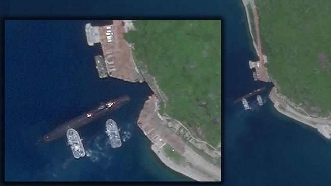
The August 18 photo, from commercial satellite service Photo Labs, was spotted by Radio Free Asia (RFA) – a US government-funded international broadcaster based in Washington D.C.
RFA’s Drake Long identified the submarine as one of China’s six modern Type 093 Shang-class attack submarines. Their mission is to hunt and kill other submarines and warships.
It was being backed out of the heavily protected underground facility.
“Given the narrow aperture of the tunnel, you are just asking for trouble for a submarine to leave the tunnel under its own power,” retired USN Captain Christopher Carlson is quoted as saying. “Most people don’t realise submarines manoeuvre like pigs on the surface.”
Submarine was exiting stern first, and was pushed towards the piers outside the bunker. All of China's other submarines normally stationed here are nowhere to be seen - wonder where they went... pic.twitter.com/ZFERRGeHQI
— Drake Long (@DRM_Long) August 20, 2020
According to the RFA report, the scene “hints at how China can marshal considerable undersea power on the doorstep of the disputed South China Sea”.
Yulin Naval Base on Hainan Island is normally a hive of submarine activity. The most recent image on Google Maps, for example, shows three submarines – two ballistic missile carriers and one smaller attack type – tied up at the open piers.
RELATED: China’s brazen move in South China Sea
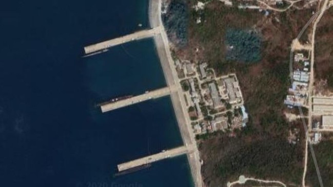
In photos from August 18, these are unusually empty.
“All of China’s other submarines normally stationed here are nowhere to be seen – wonder where they went,” Long wrote.
STRATEGIC HUB
What is or isn’t happening at Hainan Island’s Yulin Naval Base is of extreme importance to all nations embroiled by Beijing’s assertion of ownership over the South China Sea.
US surveillance aircraft, some believed to be carrying advanced imaging radars, have been observed operating in the area in recent weeks.
But while territorial disputes plague the South China Sea, nobody questions the ownership of Hainan Island. Here, China can assemble its forces without the risk of a diplomatic incident.
Sitting at the South China Sea’s northwestern extremity, the vast People’s Liberation Army facility is the key to Beijing enforcing its expansive, arbitrary claim.
Midway between it and Vietnam are the Paracel Islands seized from Hanoi in a short 1974 war.
And at roughly the midway point between Vietnam, Malaysia and the Philippines – 1150km from Hainan Island – are the artificial island fortresses of the Spratly Islands. Natuna Island, the scene of a clash between Indonesia and China earlier this year, is 1750km away.
Yulin Naval Base means business.
RELATED: Photos reveal new island fortress
Open source satellite images taken during the past two decades reveal Hainan Island has been heavily fortified in that time.
Protecting the 25sq km network of tunnels and submarine facilities are large armoured towers containing anti-ship and anti-air missile launchers. These, with a scattering of point-defence guns, also protect the nearby piers and ammunition-handling facilities.
More substantial piers nearby are designed to support surface ships. China’s two aircraft carriers have docked here, along with an array of destroyers, frigates and support vessels.
Work began on the facility in 2000. It’s not yet complete.
The mountain that dominates Yalong Bay, a 7.5km beach on Hainan, is the centrepiece of China’s nuclear deterrent.
Its earth and stone protect the submarines, crew, weapons and command facilities within. But artificial walls surround its shores. Blast walls isolate individual buildings. Rail lines lead from protected loading facilities into tunnels.
“Any US attempt to strike targets on Hainan Island would only really be practicable in the context of a larger-scale conflict and would require extraordinary effort,” Strategic Sentinel research associate Damen Cook wrote. “Yulin-East’s surface vessels and attack submarines will strengthen China’s position over important regional trade routes and attempt to coerce China’s neighbours into accepting the nine-dash line.”
Jamie Seidel is a freelance writer | @JamieSeidel
Originally published as South China Sea: Photos reveal secret underground base off Hainan Island