
Despite a damaging wind warning in place for part of the state, the winds are slowly easing
Tasmania’s battering start to spring could slowly be shifting but we’re not out of the woods yet. Here’s what the weather experts have to say.

Tasmania
Don't miss out on the headlines from Tasmania. Followed categories will be added to My News.
The winds are slowly on the way out and expected to ease into Tuesday after Tasmania experienced a rough start to Spring.
Over the next couple of days Tasmania can expect to see increased westerly winds as part of the ongoing weather system that will be much lighter than the damaging wind speeds seen over the past fortnight, according to the Bureau of Meteorology.
A damaging wind warning was issued for parts of the North and North East coasts on Sunday.
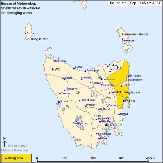
Sunday was particularly windy again, with increased westerly winds that the BOM forecast were expected to increase again on Monday afternoon before lightening on Tuesday.
“The winds are slowly on their way out,” BOM meteorologist Ellie Mathews said.
With shower activity on Sunday, the BOM was expecting to see some renewed rises in some catchments with a flood watch active for parts of the north, north west and south catchments.
Minor flood warnings were in place for the Macquarie, Meander, Mersey, North Esk, South Esk Rivers and the river Derwent and a flood warning for the Styx and Tyenna Rivers.
On Sunday, the wind was impacting more in the north, elevated parts of the west and the north east and east coast Ms Mathews said, with showers falling on most parts of the state.
She said the flooding trend was “slowly easing” despite the rainfall.
“We are seeing a little bit of a rise again in those rivers but the amount of rainfall we are seeing is not significant enough to see huge rises,” she said.
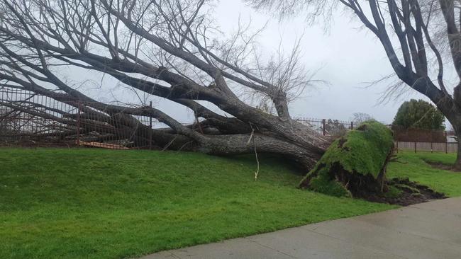
This weather system has been impacting Tasmania for almost a fortnight, with long delays expected for repairs to the extensively damaged electricity network.
TasNetworks has restored power to more than 150000 households with other customers facing unknown delays to restoration.
On Sunday afternoon there remained more than 2000 customers across 88 outages without power mainly impacting the North and North-West of the state.
Many roads across the state remained closed because of land slides, trees on the road, ongoing problems due to floods, power lines on roads and other impacts from the weather.
The Central Coast Council opened showers for those affected by the ongoing outages at the Ulverstone Sports and Leisure Centre over the weekend.
Originally published as Despite a damaging wind warning in place for part of the state, the winds are slowly easing

‘We need him home’: Daughter’s plea for help in finding dad
The daughter of a Tasmanian man missing since early Thursday morning has made an impassioned plea to the public for help in bringing her sick dad home safely.

Job cuts, fewer courses: Sweeping UTAS proposal angers staff
The University of Tasmania has put a controversial proposal to its staff that would result in job losses and fewer course offerings, attributing the move to falling student enrolments.