
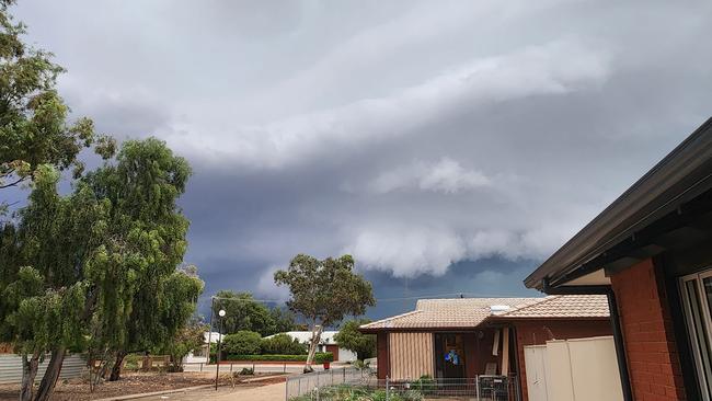
Severe weather warning in place for much of SA as the state braces for thunderstorms
With powerlines down, Olympic Dam losing operational power and thousands across the state without electricity, the state is on high alert as a severe storm rolls through.
SA News
Don't miss out on the headlines from SA News. Followed categories will be added to My News.
Powerlines have been brought down with severe thunderstorms expected across South Australia on Thursday afternoon begin to set in.
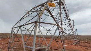
Two out of five power towers that are located in Pimba, in the state’s far north, have been brought down by the severe weather conditions.
At 9.50pm SA Power Networks reports 66 power outages, more than 22,800 customers, while State Emergency Services had responded to 109 call outs on Thursday..
High voltage network damaged
A spokesman for ElectraNet - the high-voltage network in South Australia - such as the line to Olympic Dam - confirmed that the severe weather conditions had damaged “the high voltage network”.
“Power supply has been impacted and ElectraNet crews are working to restore power as soon as possible. Further updates will be provided as investigations continue,” the spokesman said.
Bureau warn high wind locations to be safe
As severe thunderstorms move across, a Bureau of Meteorology said locations including Renmark, Port Pirie, Clare, Leigh Creek, Marree and Jamestown, may be affected. Port Pirie recorded wind gust of 137KM/H at 7.11pm, Olympic Dam Airport recorded 129km/h at 5.56pm, Tarcoola recorded 113km p/h at 4.27pm, Leigh Creek recorded 109km.h at 8.12pm and Woomera recorded 101km/h at 5.47pm.
Olympic Dam loses operational power
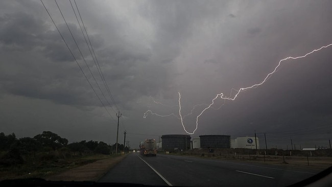
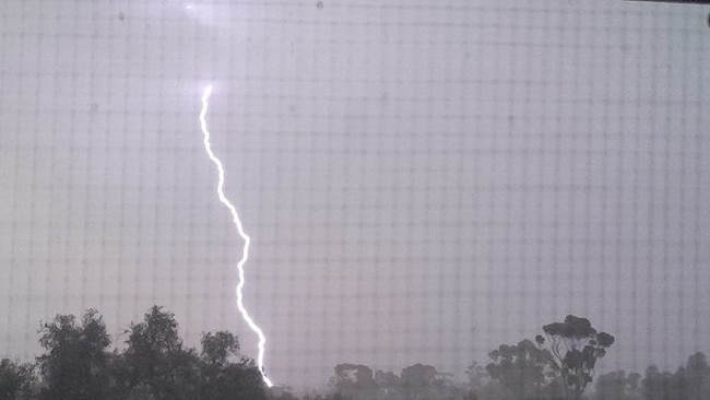
Sources have told The Advertiser BHP will be unable to mine from its Olympic Dam site for at least five to seven days after up to eight power towers connected to the operation lost power. The Advertiser understands BHP only has enough electricity to power the Olympic Dam site but not enough to continue mining operations. South Australia is currently being pommeled by between 500 to 1000 lightning strikes per minute as the storm continues its ferocity. Just across the border, Broken Hill has been “islanded” from power, The Advertiser understands.
Adelaide was forecasted to reach a top of 30C and a very high chance of showers, most likely from late in the morning, with the chance of severe thunderstorms with up to 10mm of rain to be dumped on the city.
Nuriootpa, in the Barossa Valley, is expecting a top of 28C, and it will be even warmer in the north of the state with Port Pirie expecting 36C with showers increasing, and 43C at Roxby Downs and 42C at Coober Pedy.
Showers are expected to continue into Friday but a cool change will see Adelaide tipped to reach a high of 20C, Port Pirie 22C, and as low as 19C in the South-East at Mount Gambier and Robe and at Nuriootpa.
LIVE WEATHER MAP
Hit the Play button to see how the weather will develop over coming hours
ADELAIDE RAIN RADAR
FORECAST FOR ADELAIDE
Friday, October 18: Mostly cloudy. Showers, mostly morning (1-6mm). Fresh NW/SW winds Min – 15. Max – 20.
Saturday, October 19: Mostly sunny. S/SW winds Min – 10. Max – 22.
Sunday, October 20: Mostly sunny. NE winds tending SW Min – 10. Max – 25.
Monday, October 21: Mostly sunny. E/NE winds Min – 15. Max – 31.
Tuesday, October 22: Cloudy. Late shower. NE winds tending SW Min – 19. Max – 25.
Wednesday, October 23: Partly cloudy. Late shower. SE/SW winds Min – 12. Max – 21.

Originally published as Severe weather warning in place for much of SA as the state braces for thunderstorms
Join the conversation

‘Have to take a day off work’: Heartbroken fans remember Liam
As the world mourns One Direction superstar Liam Payne, we remember his time in Adelaide, including when fans confronted dangerous snakes to get a glimpse of their idol.
Read more

Sparkle of magic fades: Beloved SA Christmas lights identity dies
A beloved northern suburbs identity known for his dazzling Christmas lights has died.
Read more