
One killed as car washed away amid severe Qld weather event
A man has died after a car was swept off a road northwest of Brisban after an East Coast Low smashed into the state, causing weather warnings to be extended. Big falls have led to water being released from two dams.
QLD weather news
Don't miss out on the headlines from QLD weather news. Followed categories will be added to My News.
A man has been confirmed dead after his car was washed away by raging waters, as a flood emergency unleashes chaos in the South Burnett region.
Police believe the man to be a 47-year-old Nanango man.
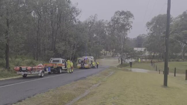
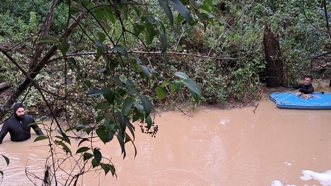
Emergency services were first called about 5.30am to reports that a vehicle had been swept into flood waters at Brown St in Nanango, and discovered the body near Sandy Creek Bridge about 8.15am.
Police divers were still looking for the vehicle several hours later and investigators will prepare a report for the coroner.
Queensland Police Inspector Scott Stahlhut confirmed the death and said police were trying to formally identify the person.
“Investigations are currently underway after a man was discovered deceased near Sandy Creek bridge in Nanango this morning,” he said.
“We currently have officers from the dive squad on the way to Nanango to assist us with our inquiries.
“A number of roads have been cut, including the Burnett Highway which is now open.”
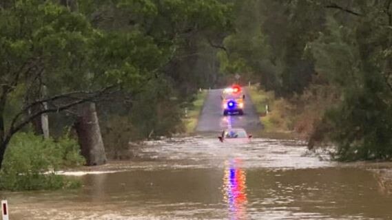
He said it was too early to know the exact circumstances surrounding the man’s death, but said that people should never attempt to drive through floodwaters.
“A significant amount of unseasonal rain fell in a very short amount of time,” he said.
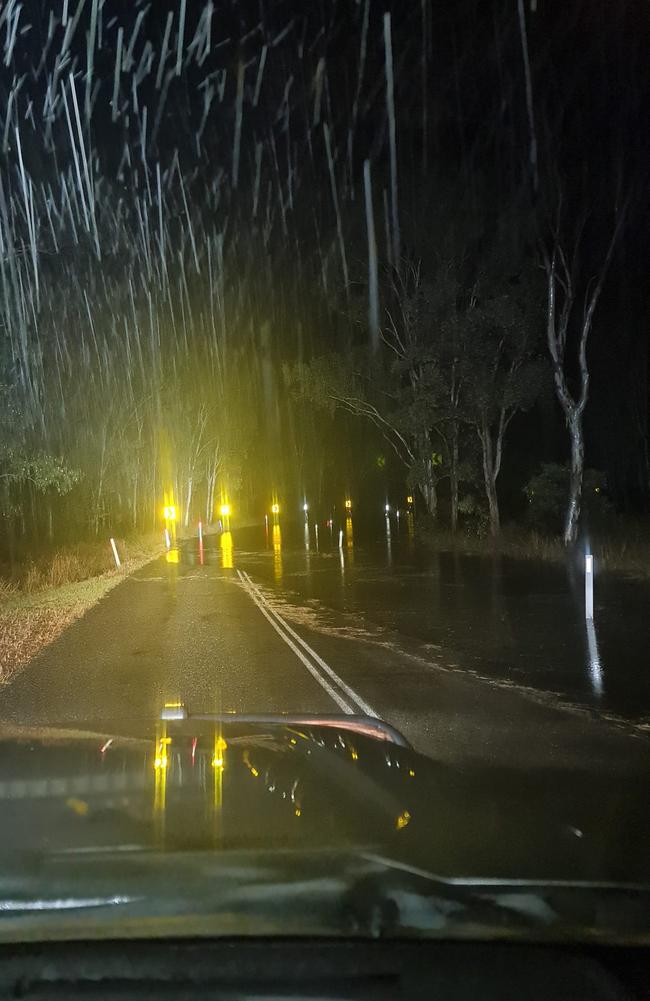
It comes as a monster storm lashes southeast Queensland, dumping up to 140mm of rain, whipping up 130km/h wind gusts and triggering an emergency alert for northwest of Brisbane.
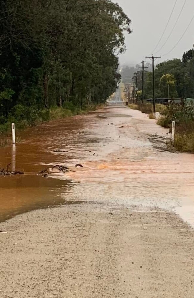
The vehicle was one of eight swept into raging waters in the region, with crews also called to Kingaroy, Taabinga and Brooklands overnight.
An emergency alert has been issued for the South Burnett Regional Council area, with a warning that roads and bridges may go under, while water was released from Wivenhoe, Somerset and Noth Pine dams on Friday.
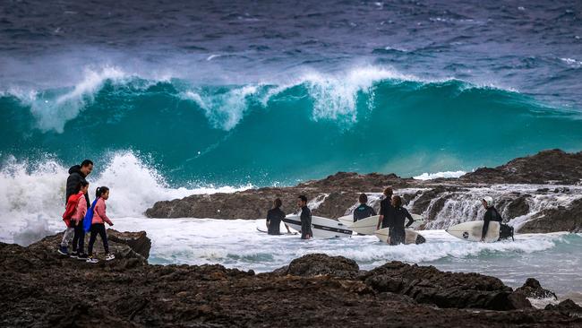
Lifeguards have #CLOSED the following beaches due to dangerous surf:#AlexandraHeadlands#CoolumBeach#DickyBeach#DiscoveryBeach#KingsBeach#MooloolabaBeach#MooloolabaSpit#MudjimbaBeach#PeregianBeach#TwinWaters
— Surf Life Saving Queensland (SLSQ) (@lifesavingqld) July 22, 2022
Please follow instructions and stay out of the water.
The Bureau has extended its weather warning for damaging winds along K’gari, Moreton and Stradbroke Islands and northern parts of the Sunshine Coast tonight, with the dangerous gusts expected to persist into Saturday morning.
Damaging winds are expected to peak at 110km/h across K’gari and average between 55-60km/hr elsewhere.
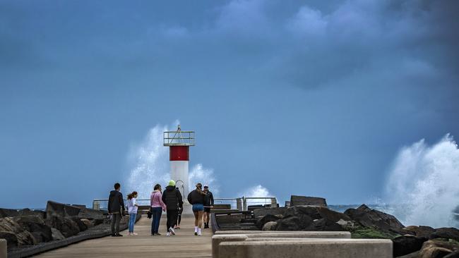
The severe surf warning for Fraser Island, Sunshine and Gold Coast waters has also been extended to Saturday and is likely to remain in place through Sunday.
Areas that will be most affected include Moreton Island, Noosa Heads, Fraser Island, North Stradbroke and Rainbow Beach.
Swiftwater rescue crews also helped retrieve 11 people from a caravan park in Scott St, Nanango, where multiple vans were being inundated by rising floodwaters.
An evacuation centre has now been established at Nanango’s cultural centre on Drayton St.
A number of people have been pulled to safety on the Sunshine Coast after a car entered a flooded causeway at Yandina on Friday morning. There were no injuries and crews were able to walk the car’s occupants to safety.
The Sunshine Coast hinterland has copped the highest rainfall totals over the past 24 hours, with more than 141mm at Maleny since 9am on Thursday.
Other nearby locations have received around 100-120mm
On the border, 111mm fell at Springbrook.

Further inland, 76mm was recorded at Kingaroy, 58mm at Proston and 60mm at Mt Mowbullan.
It comes as a monster low kicks up massive seas and winds, with the Bureau of Meteorology issuing a ‘storm force’ wind warning for the Capricornia and Fraser Coasts, a gale warning for Hervey Bay, Sunshine Coast, Moreton Bay and Gold Coast waters, and a strong wind warning for the Mackay area.
The state’s highest recorded wind gust of 131km/h was recorded at Frederick Reef, about 410km northeast of Gladstone.
A cruise ship is being forced to move in circles off the coast of Caloundra with the Port of Brisbane closed.
A Caloundra Coast Guard radio operator said the Coral Princess ship would have to move slowly all day and overnight as the Port of Brisbane wasn’t expected to reopen until early Saturday morning.
“A lot of the ships have been driven further out than they have usually been sitting because of the gale force winds,” he said.
He said the ships were battling up to five metre swells and southeasterly winds of up to 40 knots.
Ship owner Princess Cruises confirmed the ship’s entry into Brisbane would be delayed until Saturday, providing piloting services resumed and the port reopened as the weather eased.
“Guests currently on board and those who were due to embark today for the next cruise are being updated regarding the ship’s late arrival and being assisted as fully as possible,” the company said.
K’gari (Fraser Island) is also in the firing line, with peak gusts of up to 110km/hour possible.
The mainland’s highest reported wind speed was at Cape Moreton around 7.30am at 98km/h.
Boaties have been told to stay out of the water, with five-metre waves recorded at the Brisbane offshore buoy overnight.
An initial flood warning has now been issued for the Mary River, warning of likely minor flooding in Gympie Friday afternoon.
The Mary River at Dugan Pocket was at 1.88m and rising at noon and is likely to exceed the minor flooding level of 7m on Friday evening.
The Mary River at Gympie is likely to exceed the minor flood level of 6m on Friday evening.
Minor flooding is also possible at Miva on Saturday night and Tiaro on Sunday morning.
The river is expected to remain below the minor flood level at Maryborough.
Flood warnings were this morning issued for the Stanley River leading to Somerset Dam and the Brisbane River to Wivenhoe Dam.
The bureau advised that minor flooding is likely along the Stanley River at Woodford, which at 8.15am was at 2.82m and rising.
It is expected that the river will reach the minor flood level of 5m at Woodford by Friday afternoon.
The Brisbane River at Gregor Creek is also rising. At 8.15am, it had risen to 2.12m and while further rises are expected throughout the day, they are not expected to breach the 3.5m minor flood level.
A Bureau spokeswoman also said that a warning was likely to be issued for the Mary River later today.
“Rises there could lead to minor flooding in Gympie,” she said.
There were also a number of people left without power across the Sunshine Coast region, including 470 residents in the Tewantin area, 200 in the Maleny and Mooloolah Valley areas, and 170 at Pelican Waters.
Another 320 lost power at Blackbutt, just south of Nanango, while there are other, smaller outages scattered across the southeast corner.
Most are believed to have been caused by power lines knocked down in strong winds.
SEQ water said gated releases from Somerset Dam were expected before 1pm, with the releases likely to flood the following bridges and crossings – Twin Bridges, Savages Crossing, Colleges Crossing.
“We are monitoring the weather and dam conditions 24/7 at the Flood Operations Centre which is now active,” they wrote.
“If you are downstream of the dam, stay away from fast flowing or deep water near waterways and flood plains.”
Minor dam releases from Wivenhoe Dam could also eventuate before 3pm.
The system is expected to deepen across the day while moving south, before moving back out to sea on Saturday afternoon.
Marine wind and gale warnings are in place as far north as Mackay
All Gold Coast beaches will be closed on Friday and Saturday.
A Surf Life Saving Queensland spokeswoman said eight beaches were closed on the Sunshine Coast on Thursday, and that all Sunshine Coast beaches were anticipated to close on Friday and Saturday.
“This system is expected to remain offshore and primarily cause peripheral wave and wind impacts to coastal areas,” the Bureau of Meteorology’s David Grant said.
The heaviest rain on Friday is expected on the Sunshine Coast and Fraser Island with 50mm each.
More than 40mm is expected in Hervey Bay on Friday and 35mm on the Gold Coast.
Brisbane is forecast to receive 30mm today.
“At this stage, a flood watch is not expected to be issued for this event, but this will be regularly reviewed,” Mr Grant said. He urged people to listen to weather warnings and monitor conditions in their area.
“Please keep informed, make appropriate, responsible decisions and please prioritise your safety.”
Queensland Fire and Emergency Services Commissioner Greg Leach said on Thursday that people should take precautions before the worst of the weather arrives.
Mr Leach said heavy rainfall across the South East earlier this year had weakened tough soil holding trees in place, making falling trees a real possibility, particularly given that isolated gusts of 90km/h “could make their way inland”.
“Think about large trees around your property, think about where you park your car, think about loose items in your back yard and get yourself ready for the weather conditions,” he said.
Surf Life Saving authorities warned people to stay “well away” from surf-exposed areas and asked coastal residents to monitor their properties for coastal erosion or inundation.
Assistant Police Commissioner Ben Marcus said road conditions could change quickly in wet weather and reiterated that there was never a valid reason to drive through floodwaters.
“Road conditions can change rapidly when water is added to the mix, causing safe and familiar routes to be subject to incredibly dangerous conditions,” he said.
“We usually see an increase in crashes in wet conditions, many of which could have been avoided by being aware of the conditions at the time.”
The system is also expected to bring damaging winds and rough surf to northern NSW, as well as Lord Howe and Norfolk islands.
Another minor flood warning was issued for the Burnett River shortly after noon, warning that minor flooding was possible at Eidsvold Brisge, Dunollie, Gayndah, and Walla on Friday and at Mundubbera on Saturday.
Minor flooding was occurring on the nearby Auburn River by 2pm.
Originally published as One killed as car washed away amid severe Qld weather event
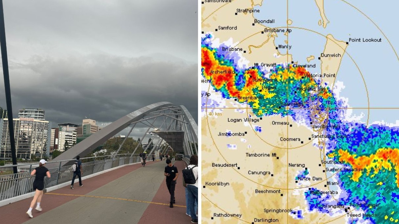
28mm rain in just 10min: SEQ hit with short, sharp storms
Brisbane smashed with thunder and lightning, while areas of the Gold Coast received 28mm of rain in just 10 minutes as storms – not severe enough to spark a BOM warning – hit the southeast.
Read more
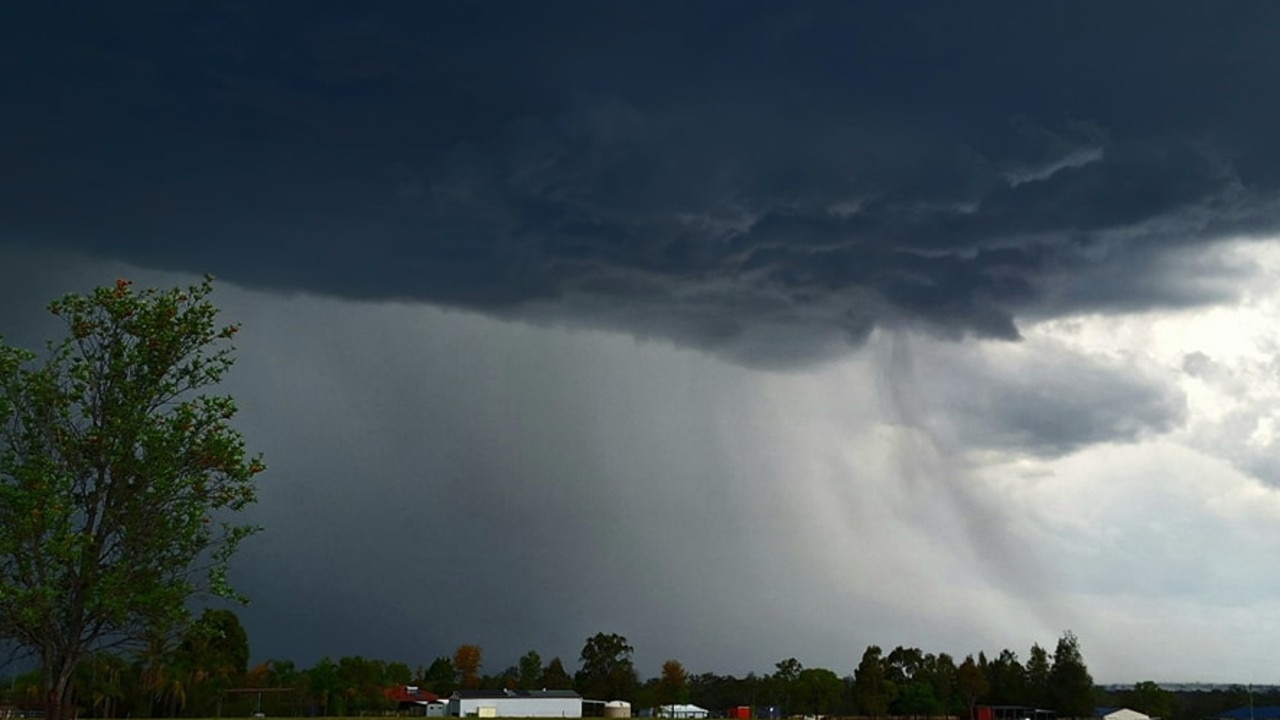
Southeast in firing line for more storms
South East Queensland could see more thunderstorms this week as a trough connected to a weather system in NSW moves towards the coast.
Read more