
Wild weather: heavy rain to stay in Sydney, Hunter into the weekend
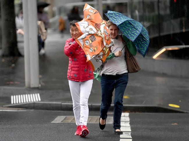
Residents remain on alert with torrential rain to drench the state this weekend, causing flash flooding across parts of NSW as well as leading to Warragamba Dam reaching capacity.
NSW
Don't miss out on the headlines from NSW. Followed categories will be added to My News.
With summer about to arrive we could be excused for asking where has the lovely sunny weather gone?
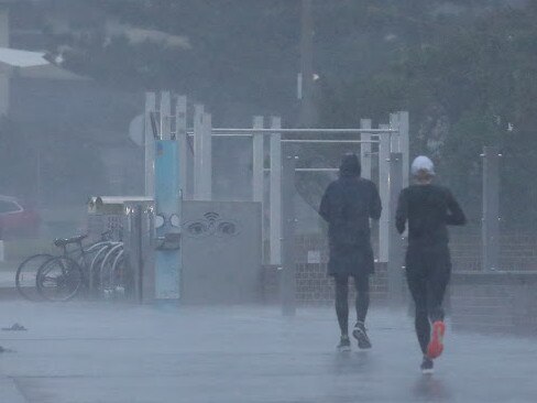
Sydney and much of NSW is forecast to be again soaked by torrential rain this weekend after days of grey skies and downpours.
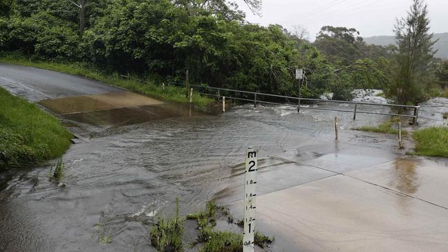
There has been so much rain Warragamba Dam was due to spill and there are minor and moderate flood warnings in northeast parts of NSW.
WaterNSW said the dam reached capacity on Friday and could continue to spill for about a week.
As of Thursday, Warragamba Dam was 98.9 per cent full.
In a statement, Water NSW said months of inflows had pushed the dam to near capacity with levels continuing to rise with rain volumes of up between 75-100mm expected on Friday alone.
The heaviest falls during the week were 261.8mm in Yarras, Mount Seaview near Port Macquarie while Sydney copped 41.8mm behind 52mm in Newcastle.
There are showers, or at the least cloudy days, forecast all the way until next Sunday, including a 70 per cent chance of up to six millimetres of rain on Wednesday, the first day of summer.
Severe thunderstorm warnings have also been in place from the Central Coast, to the Hunter and part of the Mid North Coast, while the Snowy Mountains, Southern Tablelands and South West Slopes are expected to experience “dangerous weather conditions”.
Heavy rain pummels NSW
A night of non-stop rain saw up to 50mm of rainfall in some parts of the state from Thursday, with 50.2mm of rain recorded in the Hunter town of Merriwa and 46mm of rain in western Sydney‘s Richmond by 6:30am.
Several roads were closed by the rainfall, with Macquarie St at Bell St in South Windsor closed in both directions and McClymonts Rd at Cattai Creek in Maraylya shut too due to water on the road.

In regional NSW, the Kamilaroi Hwy between Mathias Rd and Gratham St West were shut from Gunnedah to Boggabri, as is the Golden Highway (Mitchell Line of Rd) between New England Highway and Range Rd near Whittingham in the Singleton area.
Part of western #Sydney now included in new #Flood Watch. At this stage North #Richmond may see #Minor flooding this weekend. While forecast to stay way below March floods levels, it is still worth keeping a watch on updates https://t.co/4YzRuZuC9G, @NSWSES & @WaterNSWpic.twitter.com/WaEFhvMNAW
— Bureau of Meteorology, New South Wales (@BOM_NSW) November 25, 2021
A variety of minor to moderate flood warnings were issued for waterways by the Bureau of Meteorology.
BOM NSW manager Agata Imielska said the rain bomb was being caused by a slow moving deep low pressure system.
“Severe storms and rainfall is of particular concern, with the potential for flash flooding conditions which can change quickly … people need to be mindful on the roads,” she said.
Ms Imielska added while this rain bomb would move out to sea later on Friday, more rain was expected in the Greater Sydney basin over the next seven days.
“We‘re not expecting anything as substantial, but the conditions will be conducive to producing showers,” she said.
âš ï¸ Minor to Moderate Flood Warning for the #MolongCreek#Bell and #MacquarieRivers at #Molong#Wellington & #WellingtonBridge. See https://t.co/AdztI2rqg1 for details and updates; follow advice from @NSWSES#NSWFloodspic.twitter.com/iEPD4NWNSl
— Bureau of Meteorology, New South Wales (@BOM_NSW) November 25, 2021
Weather outlook
All climate outlooks are recording above average rainfalls for the season in what is described as an unusual ‘wet summer’.
“We do have dry summers with fires like a couple of years ago, but we also have wetter summers that are dominated by thunderstorms,” BOM meteorologist Helen Reid said.
“It’s interesting though to have had such a major fire season in recent memory and then have a wet season following up not long after. It’s the way that the climate drivers line up. So, it’s shaping up to be quite a wet season.”
A La Niña – where warmer than normal Western Pacific Ocean water drives moist air onto eastern Australia and which was announced on Tuesday – sees wetter than average weather for parts of the east coast.
But, in a small mercy, another climate driver to the west of Australia, the negative Indian Ocean Dipole, is dying out, and will modify La Nina’s soggy intentions.
A very wet spring in NSW has seen soil so soaked it can’t hold any more water, and that’s making flooding worse, and causing many dams to fill, or even spill.
Everyone’s least liked weather condition, humidity, is also high.
“It’s very humid because the temperature and the dew point are very close together. Relative humidity is near 100 per cent,” BOM meteorologist Neale Fraser said.
“We’ll have to wait a bit longer for blue skies.”
Torrential rain wreaks havoc
The SES emergency hotline went dead overnight due to a technical issue as the wet weather began to settle in.
“The NSW SES phone number 132 500 is currently down, we are working to resolve the issue as soon as possible,” the SES wrote on Twitter just after 8pm on Thursday, asking people in need to call Triple-0.
By 9pm, the line was back up with a “limited capacity”.
It comes as wild weather brought some trains to a grinding halt in Sydney, causing peak hour commuter chaos on Thursday.
Thunderstorms and multiple lightning strikes damaged rail equipment at Sydenham, triggering delays on the T2 Inner West, T3 Bankstown, T4 Eastern Suburbs and T8 Airport & South lines.
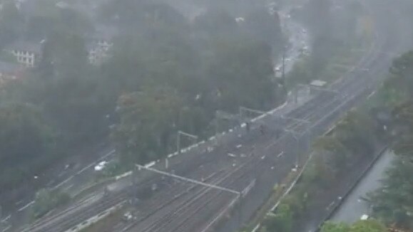
Commuters faced long delays, with some services running up to 30 minutes late as crews raced to fix the issue.
Sydney Trains warned commuters that stopping patterns and departure platforms may change at short notice.
“Customers are advised to allow extra travel time and listen to announcements and check real-time apps before boarding trains,” a spokesperson said.
âš ï¸Services are delayed due to severe thunder storms and multiple lightning strikes damaging equipment at Sydenham. Stopping patterns and departure platforms may change at short notice.
— T2 Sydney Trains (@T2SydneyTrains) November 25, 2021
DM us if you need any travel assistance pic.twitter.com/Mi3Ls4lItt
Commuters took to social media to express their frustration.
“Stuck at St Peters and can’t move. Don’t have even an estimate. Should have worked from home,” one person said.
Flooding also caused road closures in the state's Central West, while rain caused heavy traffic in parts of Sydney.
It comes as wild weather lashes parts of NSW, with the Bureau of Meteorology expecting potentially record-breaking falls in coming days.
Multiple flood warnings have been issued, including for the state’s inland rivers and Hunter River.
The State Emergency Services (SES) received 230 calls for help in the past day, mainly relating to leaking roofs, overflowing gutters and sandbagging.
#Thunderstorms south of Broken Hill are still kicking off and a Severe Weather Warning is current for heavy rainfall across much of southern NSW. Flooding is already occurring and severe storms remain a risk today & tomorrow for much of #NSW. https://t.co/vTFzG4ccXr
— Bureau of Meteorology, New South Wales (@BOM_NSW) November 25, 2021
A handful of people have also had to be rescued from floodwaters as already drenched waterways overflowed.
SES spokeswoman Cathy Harding urged people to prepare their homes amid the storm threat.
“We ask the community to take the time to prepare their property in between weather events, to make sure their gutters are clear and please call if you need assistance.”
* Additional reporting Georgia Clark and Kaitlyn Hudson-O’Farrell

Wong to go to Washington for heavy-duty US meeting
Penny Wong will head to the US amid ongoing pressure from the Trump administration to up defence spending.

‘Con-job’: Inmates work on new NSW buses, despite jobs promise
The Opposition has raised concerns over how many local jobs will be created at a NSW Government-backed bus hub, after it was revealed inmates will be working on the site.