
NSW weather: Southwest Sydney cops storms as severe weather hits along the state’s east coast
Southwest Sydney saw the first dumping of rain in the city area as storms threaten across the state’s east tonight and tomorrow.

NSW
Don't miss out on the headlines from NSW. Followed categories will be added to My News.
Large hailstones and heavy rainfall are threatening southwest Sydney as tonight’s severe thunderstorms begin to take hold across the state.
The Bureau of Meteorology issued a severe thunderstorm warning at 7pm for large hail and torrential rain in the Liverpool and Holsworthy areas, with the destructive cell moving northeast across large suburban areas of Sydney.
BOM meteorologist Alex Majchrowski said the cell had brought “potential” hail and “heavy falls” to these areas, despite weakening off as it moved further into the Sydney basin.
He said the worst of the storms would hit on Friday.
“The system was quite strong, we received readings in the low teens in Fairfield and Liverpool in just half an hour,” he said.
“It’s weakening, but there is an ongoing regional threat of thunderstorms, though the main threat is expected to be tomorrow… large hail, heavy falls and destructive winds are going to be possible.”
Holsworthy recorded 6mm of rain during the downpour, and the cell is set to potentially impact areas including Parramatta, Blacktown, Sydney Airport, Sydney Olympic Park and the Sydney Harbour.
Bureau of Meteorology meteorologist Helen Kirkup said: “We may see thunderstorms and showers this afternoon (Thursday) as they are starting to build – it will warm up to about 29 degrees,” Ms Kirkup said.
“The southerly change coming up the coast could bring possibly severe storms around the Sydney region. Anywhere in that area could receive showers, thunderstorms with hail and strong winds.
“This will ease off on Saturday with only a chance of showers and even less chance on Sunday.”
A severe storm warning was also issued by the BOM for the Northern Rivers, Mid North Coast, Illawarra, South Coast, Central Tablelands, North West Slopes and Plains, Central West Slopes and Plains, South West Slopes, Riverina and Northern Tablelands.
Flash flooding could hit Tenterfield, Tweed Heads, Murwillumbah, Casino, Kyogle and Tabula to the state’s north while large hailstones and rainfall continue to threaten Taree, Newcastle, Gosford, Sydney, Wollongong and Tamworth.
Lismore and surrounds are also expected to be impacted while on the southern border storms are expected between Eden, Albury and Bega.
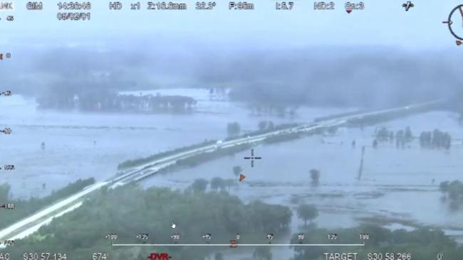
It comes as huge dumps in the state’s north have broken the banks of rivers sparking flash flooding and rockslides.
Colliding weather systems converged on the Northern Rivers around 11am on Thursday bringing a downpour.
From 11.30 to 3pm 160mm fell on Lismore. By 9am on Friday this tally had topped 200mm.
The Tweed River burst its banks and there was a slew of rockslides and minor flash floods in the region.
The largest falls of rain were at Lismore, Lester Creek, 148mm, Nimbin, 138mm, and Kungher, 187mm.
Ms Kirkup said those areas were battered due to a train-like weather system.
“The way those showers came across was in a movement where they converge and almost make a straight line. It creates, what you can imagine, is like a train effect where the areas along the train tracks get very, very wet.”
The northern town of Casino was one of those off the tracks – only recording 11mm of rainfall despite being 32km apart.
The state’s Northern Rivers will see an easing of conditions on Thursday and Friday as the weather system moves south.
More Coverage


Shots fired at home in Western Sydney
Police have launched an investigation after a number of shots were fired at a home in Sydney’s west overnight.

‘Alarmingly high’: NSW child abuse claims surge in schools
More than 1000 schools and other institutions across NSW are under investigation for historic and recent child abuse incidents, with fears some perpetrators could still be teaching in classrooms.