
NSW weather: Evacuations after Sydney rain bomb batters east coast
NSW Police have confirmed a body has been discovered in Western Sydney floodwaters while in Dapto dramatic vision has emerged showing the moment Fire and Rescue officers pulled a woman from a raging torrent.
NSW
Don't miss out on the headlines from NSW. Followed categories will be added to My News.
NSW Police have confirmed a body has been discovered in Western Sydney floodwaters after parts of the state were hit with up to 180mm of rain overnight.
Emergency services were called to King St in Penrith at about 7.45am on Saturday morning, after a member of public reported a man’s body in water near a reserve.
A statement from NSW Police said officers from Nepean Police Area Command and now established a crime scene, and said the man has yet to be formally identified.
“An investigation into the man’s death is underway and a report will be prepared for the Coroner,” the statement said.
The cause of the death has yet to be determined.
Authorities are encouraging residents to download the Hazards Near Me app to stay informed about the latest alerts.
Follow our rolling coverage for live updates as they come to hand.


DRAMATIC DAPTO RESCUE
Dramatic vision has emerged showing the moment Fire and Rescue officers pulled a woman from raging floodwaters in Dapto. (WATCH THE VIDEO IN THE PLAYER ABOVE).
The crew, from Berry, arrived at a vehicle trapped in floodwaters on Cleveland St about 7am Saturday.
The officers had initially tried to attach a floatation device to a hose in an attempt to reach the woman but failed.

Firefighters were then assisted by State Emergency Services who together waded through the water.
The driver was then fitted with a life vest and guided by the crew and rescue lines, walking her to safety through knee high water.


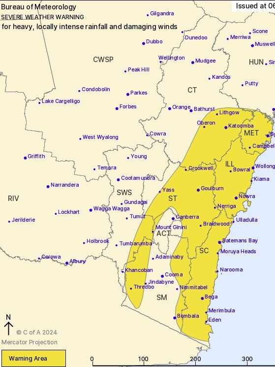
2.30pm: LATEST UPDATE FROM BUREAU OF METEOROLOGY
HEAVY RAINFALL which may lead to FLASH FLOODING is forecast for parts of the South Coast and far eastern Snowy Mountains, contracting southwards through the afternoon. Six-hourly rainfall totals between 50 to 90 mm are likely, locally reaching up to 130 mm.
Within the broad heavy rainfall area, locally INTENSE RAINFALL which may lead to DANGEROUS AND LIFE-THREATENING FLASH FLOODING is possible with localised six-hourly rainfall totals up to 150 mm possible. A separate Severe Thunderstorm Warning will be issued if very dangerous thunderstorms with intense rainfall are detected.
DAMAGING EASTERLY WINDS, averaging 60 to 70 km/h with peak gusts of around 90 km/h are possible along the coastal strip, as well as adjacent elevated areas, particularly above 500 metres.
Severe weather is expected to ease Saturday evening.
A Flood Watch is current over the area.
A Severe Weather for Damaging Surf is current.
1PM: RESCUE FROM SUBMERGED EXCAVATOR
Aerial footage has captured the moment a man was rescued from floodwaters while clinging to a submerged excavator in Erskine Park, west of Sydney.
In footage captured by 9 News’ helicopter, the man can be seen clinging to a submerged excavator as he awaits SES volunteers to assist him.


After paddling into the floodwaters, the man is safely taken back to shore.
1PM: BULLDOGS RELOCATE AFTER BELMORE LEAKS
The Bulldogs will be without a home this week with Belmore declared a flood zone.
The NRL side and staff have been forced to abandon their training facilities and offices with more than a metre of water damage from Sydney’s weekend of torrential rain.Exclusive pictures obtained by The Sunday Telegraph show the Bulldogs gym, medical and team rooms under heavy water.
The team’s video review of their win over the Roosters needed to be moved from their Belmore theatrette to Canterbury Leagues Club on Saturday morning.
But the NSW Cup fixture between the Bulldogs and Roosters at Belmore Sports Ground will go ahead at 5pm today.
12.15PM: HAWKESBURY ALERTS
Warragamba Dam, which stores about 80 per cent of Sydney’s water, is spilling over after reaching its full 2027 gigalitre capacity after heavy rainfall overnight.
WaterNSW is urging Western Sydey residents to follow the Bureau of Meteorology and SES for flooding and weather updates.

The NSW Government’s operating rules and protocols prevent the deliberate release of water from the dam - which would reduce the storage level ahead of predicted rainfall for flood mitigation purposes.
Following heavy rainfall overnight across Sydney's water supply catchments, Warragamba Dam is at full capacity and started spilling at 5:45am. Follow @BOM_NSW for flood advice and warnings and the @NSWSES as the lead agency for emergency information.
— WaterNSW (@WaterNSW) April 5, 2024
The Warragamba Dam catchment area covers 9000sqkm and stretches across much of the Blue Mountains to Goulburn in the south, and to Lithgow in the north.

12.10PM: CREEK SURGES IN BOWRAL
Footage from one resident in Bowral, in NSW’s Southern Highlands region, has captured the extent of the flood havoc as dozens of flood warnings remain in place for catchments across the state.
In the phone footage, the creek can be seen overflowing into a resident’s yard as the current continues to surge.
12.05PM: EVACUATION WARNINGS
The NSW SES has issued 11 urgent evacuation warnings for residents to leave “immediately” as floodwaters continue to rise.
One alert for low-lying areas along Sydney’s Narrabeen Lagoon covers people living in Warriewood, North Narrabeen and Narrabeen Peninsula.
“If you remain in the area, you may become trapped without power, water, and other essential services,” the SES’ warning, issued on Saturday morning, states.
“It may be too dangerous for NSW SES to rescue you, and buildings may not be able to withstand the impact of flood water.”
Another urgent evacuation warning has been issued for Picton in the Macarthur region after the town’s CBD was inundated with floodwaters.
62 alerts remain active on the SES’ website.
Multiple properties in Cumberland Reach near Sydney have been urged to evacuate, with the SES warning covering 450 to 480 Laws Farm Road and 560 to 600 and 501 Laws Farm Road.
The NSW SES is directing people in the following area to EVACUATE NOW due to rising hazardous minor flooding:
— NSW SES (@NSWSES) April 5, 2024
All of the following properties in Cumberland Reach:
- 450 to 480 Laws Farm Road
- 560 to 600 and 501 Laws Farm Road
Find out more: https://t.co/cj1SgSIv7lpic.twitter.com/LkNCFSwP1c
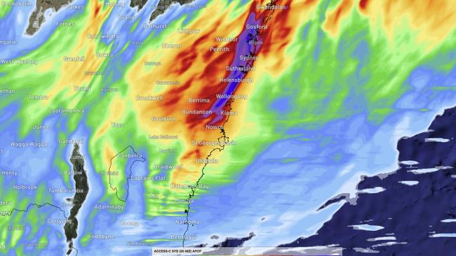
The Bureau of Meteorology has warned heavy rainfall could lead to flash flooding over the Sydney Metropolitan, Illawarra, and Central Tablelands, Southern Tablelands and South Coast regions this weekend.
Residents in the Blue Mountains and Narooma districts have been warned to brace for possible “life-threatening” flash flooding from intense local falls.
Six-hourly rainfall totals between 90 to 150mm are possible in these areas, according to the bureau.
“Localised 24-hourly rainfall totals between 120 and 200mm are possible and may reach up to 300mm over the Illawarra escarpment,” the bureau’s warning states.
Damaging wind gusts of up to 90kmh have also been forecast in the South West Slopes and along coastal parts of the Sydney Metropolitan area.
Peak wind gusts of up to 125kmh have also been forecast for alpine regions but the bureau says this will ease through Saturday morning.
12PM: TRANSPORT WARNINGS
NSW transport authorities have warned multiple major roads are now completely closed due to flooding.
The Wakehurst Parkway is closed in both directions due to flooding between North Narrabeen and Oxford Falls, Transport for NSW said in a statement.
“Oxford Falls Rd is closed in both directions due to flooding between Wakehurst Parkway and Aroona Rd,” the statement continues.
In addition, the Princes Highway closed northbound at Engadine and Macquarie St being closed in both directions between Bell St and Brabyn St at Windsor
South of Sydney, the Illawarra Highway is closed in both directions between Tongarra Rd and the M1 at Albion Park, and at Macquarie Pass.
The Newell Highway remains closed in both directions between Moree and Boggabilla.
Multiple train lines have also been cancelled and buses are replacing ferries between Paramatta and Rydalmere due to the weir overflowing.

Major Sydney roads closed to motorists due to flooding:
- Wakehurst Parkway is closed in both directions due to flooding between North Narrabeen and Oxford Falls.
- Oxford Falls Road is closed in both directions due to flooding between Wakehurst Parkway and Aroona Road.
- The Princes Highway is closed northbound at Engadine.
- Cambridge Avenue is closed both directions between Moorebank Avenue and Railway Parade at Glenfield.
- Bells Line of Road is closed in both directions at Richmond Bridge.
- Wisemans Ferry Road is closed in both directions at Cattai.
- Macquarie Street is closed in both directions between Bell Street and Brabyn Street at Windsor.
- Bexley Road is closed both directions at Bexley North.
- Illawarra Highway is closed in both directions between Tongarra Road and the M1 at Albion Park.
- Illawarra Highway is also closed at Macquarie Pass.
- Newell Highway remains closed in both directions between Moree and Boggabilla.
Other roads where motorists are advised to take extra care due to water on the road include:
- Centenary Drive at Strathfield
- Epping Road at Lane Cove North
- Newbridge Road at Moorebank
- Hume Highway at Lansvale
- Lawrence Hargrave Drive at Coalcliff
Affected public transport routes:
- T8 Airport & South Line, no trains are running between Turrella and Glenfield due to flooding at Bardwell Park. A shuttle train is in operation between Turella and Central via Airport Line stations. Limited train services will operate between Glenfield and Campbelltown.
- T7 Olympic Park Line, trains are not running between Lidcombe and Olympic Park.
- South Coast Line, no trains are running between Waterfall and Dapto, between Wollongong and Port Kembla, and between Kiama and Bomaderry, due to flooding on the tracks at various locations.
- Southern Highlands Line: Trains are not running between Campbelltown and Moss Vale due to flooding at Picton.
- Hunter Line: Trains are not running between Newcastle Interchange and Maitland due to flooding on the tracks at Sandgate.
- Most other lines are affected by delays.
- Passengers who do need to travel are advised to listen to announcements and check information displays for service updates.
- L3 Kingsford Line services are not running between Moore Park and Juniors Kingsford, due to flooding due to water over tracks.
- Buses are replacing ferries between Parramatta and Rydalmere due to the weir overflowing.
- Some bus routes across the Sydney bus network are impacted due to localised flooding with local diversions in place.
11AM: LANDSLIDE IN BLUE MOUNTAINS
The Megalong Valley near Katoomba in the Blue Mountains has been cut off by a landslide last night.
The landslide saw the roadway slip away on Megalong Rd, 600m south of Shipley Rd, requiring it to be closed.

9.30AM: SES BUSY WITH RESCUES
The SES has received more than 4000 calls for help across NSW in the past 24 hours and has performed 44 flood rescues.
Despite the blue skies this morning, the flood threat continues, with Warragamba Dam spilling over from 5.45am — days ahead of when it was initially expected.

Residents downstream have been put on alert, with the SES issuing a watch and act warning.
The dam is currently spilling 138 gigalitres per day, and expected to reach a peak flow of 300 gigalitres per day at midnight tonight.
Residents in low-lying areas along the Hawkesbury-Nepean river system are expected to feel the affects of high river levels for the next few days.
Flood warnings have been issued for residents along the eastern side of the Hawkesbury River.
The Richmond and Yarramundi bridges across the Hawkesbury River are currently closed, and the Windor bridge is likely to be closed later today.


Following heavy rainfall overnight across Sydney's water supply catchments, Warragamba Dam is at full capacity and started spilling at 5:45am. Follow @BOM_NSW for flood advice and warnings and the @NSWSES as the lead agency for emergency information.
— WaterNSW (@WaterNSW) April 5, 2024
8.30AM: FLOOD WARNINGS ISSUED
NSW’s State Emergency Service (SES) has issued 11 urgent evacuation warnings for residents to leave “immediately” as floodwaters continue to rise.
One alert for low-lying areas along Sydney’s Narrabeen Lagoon covers people living in Warriewood, North Narrabeen and Narrabeen Peninsula.
“If you remain in the area, you may become trapped without power, water, and other essential services,” the SES’ warning, issued on Saturday morning, states.
“It may be too dangerous for NSW SES to rescue you, and buildings may not be able to withstand the impact of flood water.”
Another urgent evacuation warning has been issued for Picton in the Macarthur region after the town’s CBD was inundated with floodwaters.
62 alerts remain active on the SES’ website.
Multiple properties in Cumberland Reach near Sydney have been urged to evacuate, with the SES warning covering 450 to 480 Laws Farm Road and 560 to 600 and 501 Laws Farm Road.
The NSW SES is directing people in the following area to EVACUATE NOW due to rising hazardous minor flooding:
— NSW SES (@NSWSES) April 5, 2024
All of the following properties in Cumberland Reach:
- 450 to 480 Laws Farm Road
- 560 to 600 and 501 Laws Farm Road
Find out more: https://t.co/cj1SgSIv7lpic.twitter.com/LkNCFSwP1c
The Bureau of Meteorology has warned heavy rainfall could lead to flash flooding over the Sydney Metropolitan, Illawarra, and Central Tablelands, Southern Tablelands and South Coast regions this weekend.
Residents in the Blue Mountains and Narooma districts have been warned to brace for possible “life-threatening” flash flooding from intense local falls.
Six-hourly rainfall totals between 90 to 150mm are possible in these areas, according to the bureau.
“Localised 24-hourly rainfall totals between 120 and 200mm are possible and may reach up to 300mm over the Illawarra escarpment,” the bureau’s warning states.
Damaging wind gusts of up to 90kmh have also been forecast in the South West Slopes and along coastal parts of the Sydney Metropolitan area.
Peak wind gusts of up to 125kmh have also been forecast for alpine regions but the bureau says this will ease through Saturday morning.

The past 24 hour’s wild weather has been attributed to a deepening trough along the NSW coast under the influence of a slow-moving upper level low over the central part of the state.
“Areas of heavy rain and gusty showers and a few thunderstorms will become more widespread south of about Gosford, including over the ranges and tablelands,” the bureau’s severe weather warning states.
“Severe weather has started easing from the north and will continue to do so this morning as the trough moves southeast to the Tasman Sea.”
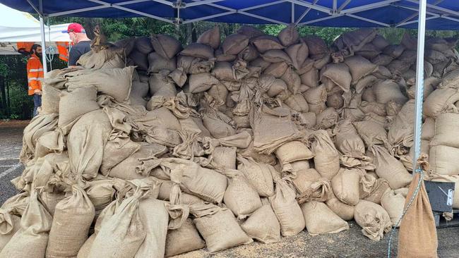
Multiple evacuation centres have already opened and are accepting residents amid the deluge.
People on the eastern side of Chipping Norton — next to the Georges River, near Bankstown in Sydney’s south west — were told to get out before midnight on Friday.
Flooding is also possible at Emu Plains, Penrith, North Richmond, Lower Portland, Freeman Reach, Sackville North, Picton, Ebenezer, Bligh Park, Jamisontown, Mulgoa, Gronos Point and Agnes Bank – all in Sydney’s western fringes.

7.45AM: RANDWICK RACECOURSE COPS IT
Sydney’s iconic Doncaster-Derby Day meeting will go ahead despite Royal Randwick being swamped by overnight rain.
Royal Randwick has received nearly 200m of rain in the last 24 hours including a deluge just before 5am which left surface water on the track and infield.
After an early morning stewards track inspection, the course proper was rated a heavy 10 but safe for racing.
Stewards were concerned about an area of the track near the 1000m where surface water was present from a catchment overflow.
But they delayed their decision for nearly an hour before declaring the track safe for racing.
The scratchings deadline of 7.30am was also delayed as stewards continued their track inspection.
The weather radar showed the worst of the weather has passed Sydney with sunshine likely for the rest of the day and a forecast top temperature of 28c.
But the extremely heavy track conditions resulted in 32 scratchings including Zougotcha, Golden Mile, Semana and Southport Tycoon out of the $4 million Doncaster Mile.
Randwick: Meeting will proceed on a Heavy 10. Section near the 1000m is consistent with the rest of the track and is suitable to race. @aus_turf_club
— Racing NSW Stewards (@RNSWStewards) April 5, 2024
7AM: COOKS RIVER SPILLS OVER
In Sydney’s inner west, the Cooks River has burst its banks at Earlwood just after 6am, forcing road closures.
Early morning traffic to bank up as people attempt to exit the area via Canterbury Rd.
“There is a lot of water on the road at the Wardell Rd Cooks River bridge, with police directing traffic out of the area,” one commuter told The Saturday Telegraph.
They were about to get through the road when the road was cautiously reopened for traffic at 7.45am.

âš ï¸Severe thunderstorm warning for intense rainfall and flash flooding is current across the #Illawarra.
— Bureau of Meteorology, New South Wales (@BOM_NSW) April 5, 2024
Monitor for updates at https://t.co/Ss766eSCrL pic.twitter.com/CnwloaRXLg
6AM: CHIPPING NORTON EVACUATES
We’re waking on Saturday to 33 flood warnings from the NSW SES, after Sydney, the Central Coast and the Hunter have been lashed by a monster storm.
The rain gauge at Sydney Airport reported a total of 145mm of rain since 9am Friday.
In Penrith, 167mm of rain has been recorded since 9am — with 17mm falling between 1.30am and 2am.
The NSW SES has issued a number of flood evacuation warnings for some people along the Hawkesbury River, including the lower parts of Richmond and Windsor.
A severe weather warning for heavy, locally intense rainfall and damaging winds is current for the east coast of NSW from Palm Beach down to the NSW-Victorian border.
A wind gust of 89km/h was recorded on Sydney Harbour at 4.12am.
âš ï¸A Severe Thunderstorm Warning and a Road Weather Alert has been issued for #Sydney. Heavy to intense rainfall and flash flooding is possible. Expect rain to ease this morning.
— Bureau of Meteorology, New South Wales (@BOM_NSW) April 5, 2024
Monitor updates at https://t.co/Ss766eSCrL pic.twitter.com/JR8XS6KeNS
8.40PM: CHIPPING NORTON RESIDENTS TOLD TO LEAVE BY MIDNIGHT
Residents in the low-lying areas of Chipping Norton have been ordered to evacuate their homes before midnight on Friday.
The SES has issued the emergency warning due to “dangerous and rising” floodwaters.
An evacuation centre has been set up at Club Liverpool for those affected by the flooding threat.


All properties in the following streets have been ordered to leave their homes and stay with friends, family or alternate accommodation until flooding subsides:
– Newbridge Rd between Riverside Rd and east to Georges River
– Riverside Rd between Childs Rd and Newbridge Rd
– Davy Robinson Dr
– Rickard Rd
– Arthur St.

8PM: RESIDENTS TOLD TO PREPARE TO EVACUATE
Residents in areas across Sydney have been told to prepare to evacuate because of the threat of serious flooding.
The SES has advised residents near Narrabeen Lagoon, in parts of Cattai, parts of Sackville and those who live along the eastern side of the Hawkesbury River to remain vigilant and get ready to move out at short notice.
“You should monitor the situation and prepare to evacuate so that you can safely evacuate when instructed to do so by NSW SES,” the warning read.


“Wherever possible, you should prepare to stay with family or friends, or make other accommodation arrangements.
“If you remain in the area, you may become trapped without power, water, and other essential services. It may be too dangerous for NSW SES to rescue you.”
6PM: SERIOUS CRASH IN CENTRAL WEST
Several people have been injured in a major two-car crash in the state’s central west as rain pelts down on the Castlereagh Highway.
Six people were injured, with the weather conditions making it particularly difficult for emergency services and first responders.
Two children have been flown to The Children’s Hospital at Westmead while two men, one in his 50s and another in his 30s have been taken to hospital in Mudgee.
Another man in his 60s was flown to Royal North Shore.
5PM: LIFE THREATENING FLASH FLOODING
(LATEST UPDATE FROM BUREAU OF METEOROLOGY)
A trough is forecast to deepen over eastern NSW and along central parts of the coast on Friday and Saturday, under the influence of a slow-moving upper-level low over central NSW.
There will be areas which experience heavy rain and gusty showers, and a few thunderstorms will become more widespread south of about Newcastle this evening, including over the ranges and tablelands.
Severe weather is expected to gradually shift south overnight and Saturday, while easing from the north as the trough moves southeast to the Tasman Sea.
Heavy rainfall, which may lead to flash flooding, is forecast for the southern parts of the Hunter to the Sydney Metropolitan, Illawarra, and Central Tablelands districts on Friday, then shifting south to the remaining districts overnight into Saturday while easing from the north. Six-hourly rainfall totals between 50mm to 90mm are likely, reaching up to 130mm over the Blue Mountains and Illawarra escarpment. 24-hour totals of 70 to 120 mm are also likely, reaching up to 150 mm over the Blue Mountains and Illawarra escarpment.

Locally intense rainfall, which may lead to dangerous and life-threatening flash flooding, is possible between the Blue Mountains and Narooma from this evening into Saturday morning, then extending further south later on Saturday, with localised six-hourly rainfall totals between 90 to 150 mm possible, reaching up to 220 mm over the Illawarra escarpment.
Localised 24-hourly rainfall totals between 120 and 200 mm are possible, and may reach up to 300 mm over the Illawarra escarpment.
A separate severe thunderstorm warning will be issued if very dangerous thunderstorms with intense rainfall are detected.
Damaging easterly winds, averaging 60 to 70 km/h with peak gusts of around 90 km/h are possible from this evening along the coastal strip south of and including coastal parts of the Sydney Metropolitan area, as well as adjacent elevated areas, particularly above 500 metres.
The widespread severe weather risk is forecast to clear south of the Hunter and Sydney Metropolitan areas by sunrise on Saturday, the Illawarra by late Saturday morning and the South Coast by Saturday afternoon. More isolated severe thunderstorms may redevelop on Saturday afternoon.
A Flood Watch is current over the area.
A Severe Weather for Damaging Surf is current.
FLASH FLOODING, THUNDERSTORM WARNING
Senior Meteorologist Angus Hines from the Bureau of Meteorology said large parts of the east coast in NSW will experience extreme rainfall and are at risk of flash flooding throughout Friday evening.
The warning comes as NSW SES reveals it has received more than 820 calls for help along the east coast, mostly for help with fallen trees, leaking roofs and sandbagging assistance.
More than 830 volunteers have assisted people across the state in the past 24 hours.
“Our severe weather warning at the moment is covering a large area of eastern and southern parts of NSW, stretching from around Newcastle in the Hunter area down to Bega on the South Coast, including all of the greater Sydney area, the Illawarra area and pushing into the Central Tablelands,” Angus Hines from the Bureau of Meteorology said on Friday afternoon.

“Through this region we’re looking at heavy to locally intense rainfall, that could mean 100-200mm in the next 24 to 36 hours, and a couple of spots might see more than that.”
Mr Hines said parts of greater Sydney and the Illawarra escarpment could potentially record a 300mm downpour, which would mark more than two months worth of April’s average rainfall in just 36 hours.
“The heaviest rain likely to occur around the Illawarra escarpment and mainly inland parts of the greater Sydney area as well where up to 300mm is possible through the course of this entire rainfall event,” he said


“We also anticipate damaging wind gusts through this area, exposed places could reach 90km/h.
“Severe thunderstorms are possible which can lead to localised flash flooding and very dangerous conditions along the water with large and powerful surf and gale force winds.”
The senior Meteorologist said that most of the rain will be cleared out of NSW by Saturday afternoon.
“Over the course of Saturday we’ll see a gradual southwards movement to this primary rainband, going through southern parts of NSW, a lower pressure area will develop along this coastal trough as well,”
“By Saturday afternoon and certainly into Saturday evening the rain will be affecting eastern parts of Victoria and Tasmania … by enlarge clearing out of a lot of NSW by the end of the day on Saturday. “
WARRAGAMBA DAM TO SPILL AS DELUGE UNLEASHED
NSW Premier Chris Minns addressed media on Friday morning in partnership with NSW SES Commissioner Carlene York.
Mr Minns said Warragamba Dam, 65km west of Sydney, was currently sitting at more than 96 per cent of its supply capacity.
“We require about 90mm of rain to fill [the dam] … we’re expecting 100 to 150mm of rainfall over that catchment as a result of this event,” he said.

The Premier said the dam would likely spill on Monday as a result.
Ms York said resources, vessels and high clearance vehicles have been positioned to help communities that may be affected by high rainfall and storms, but urged residents to take the necessary steps to keep themselves safe.
“Really important that people keep themselves safe and also that you look after yourselves and family and make sure that we don’t have to send our volunteers out to help you and put their lives at risk,” she said.
Ms York said residents should ensure their gutters have been cleared and items within their property are tied down.

She also warned motorists to stay away from flood waters, noting only a small amount of water can move a vehicle or truck.
“The message to the community is, if you see a flooded road, don’t drive through it and take a longer way around because it’s better to get to your destination safely than put you or your family or other members of the car at risk by going in,” she said.
“It is probably the most guaranteed way to put yourself in harm’s danger and you could lose your own life.”
The last time Warragamba Dam last spilt was in 2022, which led to the devastating floods in the Windsor region that saw droves of homes inundated with floodwaters and millions of dollars in damages.
100mm OF RAIN IN 24 HOURS
The State Emergency Service is poised for flash and life-threatening flooding as more than 100mm of rain fell on Sydney’s CBD in the last 24 hours.
Sydney’s train network is facing major delays and some roads have closed due to flooding.
Areas facing the most risk of flooding on Friday include Sydney’s west, Richmond, Camden, Liverpool, Tempe the Blue Mountains and the Illawarra.
“Six-hourly rainfall totals between 50 to 90mm are likely, reaching up to 130mm over the Illawarra escarpment,” the Bureau of Meteorology said in a statement on Friday.
“Twenty-four hour totals of 70-120mm are also likely, reaching up to 150mm over the Blue Mountains and Illawarra escarpment.”


Strong winds are also affecting flights leaving Sydney, 92 domestic flights have been cancelled at Sydney Airport but all runways currently remain open.
Power outages in central Sydney have also forced the delay of some court hearings with about 1300 customers without power after a substation flooded.

More than 800 SES volunteers have responded to over 500 calls for help including seven flood rescues.
Sydney CBD has been hit with more than 100mm of rain since 9am on Thursday.
The average rainfall in greater Sydney for the month of April is 106mm, meaning the harbour city is expected to get two months of rain in just two days.
WEATHER WARNING UPGRADED TO ‘WATCH AND ACT’
The State Emergency Service upgraded the weather warning to ‘watch-and-act’ for the areas along the east coast from Newcastle all the way down to Bega, including Sydney, the Illawarra, The Central Coast and the Blue Mountains on Friday morning.
The Bureau of Meteorology issued severe weather warnings for heavy and intense rainfall as well as damaging winds for several areas across the state.
“Intense rainfall which may lead to dangerous and life-threatening flash flooding is possible between the Blue Mountains and Narooma from this evening into Saturday morning, with localised six-hourly rainfall totals between 90 to 150mm possible, reaching up to 220mm over the Illawarra escarpment,” the BOM said on Friday.
“Localised 24-hourly rainfall totals between 120 and 200mm are possible, and may reach up to 300mm over the Illawarra escarpment.
The BOM said a separate warning would be issued if dangerous thunderstorms were detected.
HEAVY RAIN CLOSES NSW SCHOOLS
The severe weather has forced a number of schools across the state to cancel classes for the day.
There are currently 10 NSW schools closed:
Public schools: Baryulgil Public School, Coffee Camp Public School, Corndale Public School, Longneck Lagoon Environmental Education Centre, Megalong Public School, North Star Public School, Orama Public School and Tulloona Public School.
Independent schools: AI-Faisal College Auburn and Bhaktivedanta Swami Gurukula School in Eungella.

ROAD CLOSURES AND PUBLIC TRANSPORT DELAYS
The Eastern Distributor off-ramp to Bondi and Randwick is closed southbound due to water over the road. Motorists should use the Dacey Ave exit instead.
Southbound lanes on Harris St between Allen and Fig St in Ultimo are also closed due to flooding.
Water is also blocking roads in St Peters and Rushcutters Bay.
Oxford Falls Rd between Wakehurst Parkway and Aroona Rd is experiencing significant flooding.
Motorists have been advised to use an alternative route and allow for extra time.
Several major train lines across Sydney’s network have been affected by the torrent of rain on Friday morning.
âš ï¸ #NorthShoreLine & #WesternLine allow extra travel time from the City due to weather damaging equipment at Redfern.
— T1 Sydney Trains (@T1SydneyTrains) April 4, 2024
Trains are running frequently but, trips may take longer than normal & stops may change at short notice.
Tweet us for help with travel. pic.twitter.com/gmBiPbiSqC
The T1 North Shore and Western Line, the T2 Inner West and Leppington Line and the T9 Northern Line all have trains running at a slower frequency due to the damaging weather.
“Allow extra travel time from the City due to weather damaging equipment at Redfern,” Sydney Trains said on X.
“Trains are running frequently but, trips may take longer than normal & stops may change at short notice.
“Please check information screens and listen to announcements for service updates.”
MINOR FLOODING IN LISMORE
NSW’s Northern Rivers copped the brunt of Thursday’s rainfall, with minor flooding affecting the region.
Much of the low-level water receded off Lismore roads overnight but there is still significant flooding in low-lying paddock areas.

Lismore SES said the weather system moved slowly through the Northern Rivers overnight, producing some heavy falls in localised areas.
Rainfall since 9am yesterday throughout the region included:
Nashua – 80mm
Houghlahans Creek – 93mm
Coopers Shoot – 86mm
The system was moving south of Lismore on Friday morning, with some rainfall still forecast throughout the region.

NSW SES and the Bureau of Meteorology is monitoring the situation closely.
A ‘Flood Watch’ is still current for Coffs, Tweed and Rous Rivers and the Bellinger River.
Minor flood warnings are current for the Wilsons River at Lismore and Richmond River at Coraki.
WILDLIFE SANCTUARY EVACUATED
It only took 30 minutes for the Byron Bay Wildlife Sanctuary to go completely underwater on Thursday afternoon.
“Sudden downpour wreaked havoc on our beloved Sanctuary park in the Northern Rivers, in just thirty minutes, half of our sanctuary was submerged underwater,” Byron Bay Wildlife Sanctuary said in a statement.


“But in the face of this natural disaster, our incredible teams didn’t hesitate — they sprang into action to ensure the safety of our precious animals.
“We’ve lost vital perimeter fences, endured substantial damage to enclosures, pathways, and buildings, and the threat of more rain looms over us.”
Fortunately zoo keepers managed to relocate all of the animals before the flood waters rushed in.

“We have been able to move animals to higher ground on site and thanks to a few of the rescue groups around the region we have acquired some temporary enclosures for moved animals.”
BLACK NOR’EASTER
Australia’s east coast is copping a drenching Friday morning as two weather systems converge over Queensland and NSW.
Also known as the “black nor’easter”, the phenemon occurs when a cut-off low and coastal trough interact at the same time, often a recipe for heavy rainfall and flooding.
The name derives from the darkness of the moisture-rich clouds coming from the northeast, that can turn the middle of the day as dark as twilight.
Do you have a story for The Daily Telegraph? Message 0481 056 618 or email tips@dailytelegraph.com.au
Join the conversation

Probe after Sydney dancer dies suddenly
A coroner will investigate the shocking death of a talented 18-year-old Sydney dancer who died suddenly in her home.
Read more

Controversial Islamic centre hosts sermon attacking the West
An Australian cleric has claimed Muslims are being “belittled” without sharia law, while calling down the “wrath of Allah” on Western powers at a fiery sermon in western Sydney.
Read more