Massive dust cloud erupts over Broken Hill as storm front moves through on its way to Sydney
PARTS of NSW have already received more than 40mm of rain over the last 24 hours but a spokesman from the Bureau of Meteorology says “it’s not enough to break the drought.”
NSW
Don't miss out on the headlines from NSW. Followed categories will be added to My News.
BIG rain clouds due to hit Sydney today have already dumped more than 30mm in the state’s far west.
The small town of Ivanhoe, located between the Lachlan and Darling rivers has received 40.2mm of rain over the last 24 hours, the most across NSW.
Other drought stricken areas such as Dubbo (15.6mm) and Cobar (13mm) also welcomed some much-needed rain.
A light downpour has covered the city this morning and it is expected to pick up throughout the day. The Sydney rain is expected to peak overnight before mostly clearing off tomorrow.
While rain has finally fallen across the state over the last 24 hours, a spokesman from the Bureau of Meteorology says “it’s not enough to break the drought”.
Most of the rain is expected to move up to the Hunter Region on Friday.
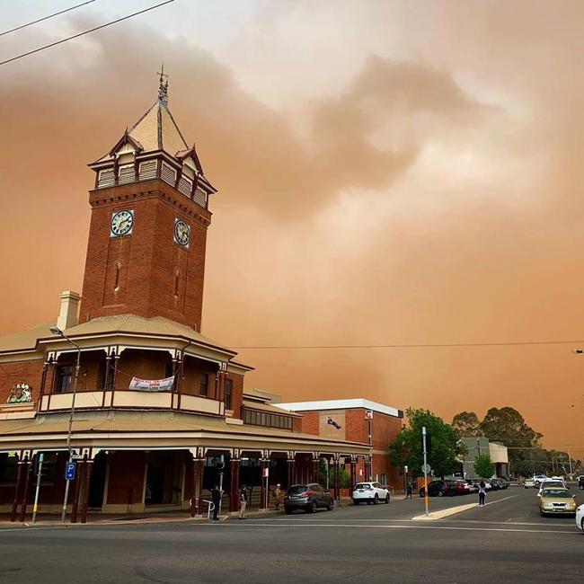
Spectacular photos uploaded to social media on Wednesday afternoon show thunderstorms whipping up dust before bringing much needed rain to farmers around Broken Hill.
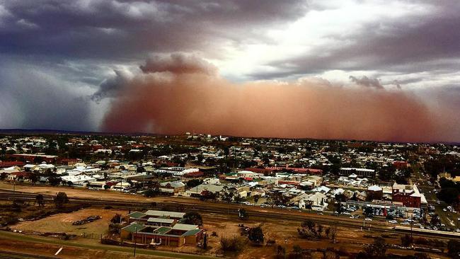
Broken Hill has recorded a massive dumping of 33.4mm since 3.30pm — more rain than the town had previously received all year amid a prolonged dry spell.
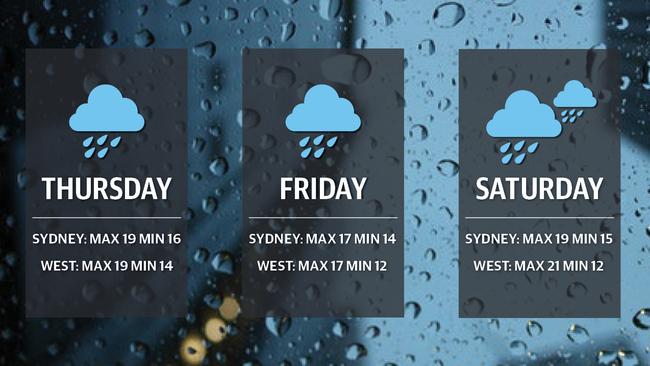
The Bureau of Meteorology has predicted more than 30mm of rain could hit Sydney from Thursday morning before the day heads for a top of 19.
MORE NEWS
TOURISM BOOM AS PUNTERS ROLL IN FOR THE EVEREST
CONVICTED TERRORIST A NO-SHOW AT HEARING
GST SHAKE-UP COULD RIP $5.5 BILLION FROM NSW
Duty forecaster Jake Phillips said the rain could last for at least two days before beginning to clear on Saturday in time for the weekend.
“Thursday is looking like the wettest day with potentially lengthy rain periods,” he said.
“It’s due to a trough of low pressure that’s moving across the state. Increased humidity is bringing down air from the north and it’s triggering the rain.”
Regional areas west of Sydney could see thunderstorms before the bulk of the rain clears by Friday.