
Hunter Region floods: before-and-after aerial imagery reveals damage and devastation
Incredible before-and-after aerial imagery by Nearmap reveals how far floodwater rose in the Hunter Region in the recent floods. Check out the photos.
NSW
Don't miss out on the headlines from NSW. Followed categories will be added to My News.
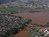
Incredible before-and-after aerial imagery has revealed the extent of recent deluge and devastation in the Hunter Region following the July 2022 floods.
The Hunter River peaked just shy of 14m last week, spilling across several rural communities and submerging properties for days.
Thousands of residents were displaced from their homes in Singleton, Maitland, and Wollombi, as well as Farley, Lower Belford and Louth Park, to name a few.
People lost precious belongings, livestock and assets as the river rose around them, leaving many stranded with limited resources until help was available.
The aerial imagery, provided by Nearmap, shows how far the murky floodwaters have travelled.
Check out the incredible photos below.
More Coverage

Read related topics:NSW floods
Join the conversation

Mayor’s plea: Give us the bat bite vax
Ballina’s Mayor has led calls for a potentially lifesaving bat bite treatment to be stocked at regional hospitals amid claims a lyssavirus victim was sent home because it was not stocked.
Read more

NSW’s largest council to jack up rates $170 for a year
Blacktown, the state’s most populous council, has unveiled a plan to hike rates to avoid a looming $700m blackhole.
Read more