
How wet summer and saturated ground led to NSW’s flooding disaster
Record flooding across the mid-north coast that claimed the lives of three people and destroyed countless homes was partially caused by an unusually wet summer.

NSW
Don't miss out on the headlines from NSW. Followed categories will be added to My News.
Record flooding across the mid-north coast that claimed the lives of three people and destroyed countless homes was in part caused by an unusually wet summer.
Off the back of major floods in 2021 and 2022, for many it seems like the state has seen some of its wettest years in memory.
Meteorologists have said the intensity of the flooding was likely caused by a confluence of factors, including warmer than usual ocean temperatures, which added large amounts of moisture to the atmosphere.
Taree and its surrounding were subjected to flooding at record levels across Wednesday and Thursday, with the Manning River at Taree reaching 6.44 metres, breaking the last record of 6m set in 1929.

Many towns received record three-day rainfalls, which broke records from March 2021. The town of Yarras on the Hastings River west of Port Macquarie received 614mm rain across three days, the most ever seen in the 66 years data for the area has been collected.
At Taree, 501mm fell in three days, breaking another record.
Sky News meteorologist Alison Osborne said the reason the rainfall was occurring over such a long period of time was because the weather system had not been moving for the last three days and in that time had picked up a lot of moisture.
She said a high pressure system over the Tasman Sea and an upper low pressure system over inland NSW that had not moved created “a blocking weather pattern that led to stationary, unchanging Groundhog Day weather”.
While the weather system itself is not unusual, Ms Osborne said it had been exacerbated by ocean temperatures that were at “near record” levels. The higher the ocean temperatures, the more moisture that evaporates into the atmosphere.
“We have had near-record sea surface temperatures surrounding Australia for the last 10 months … the waters are warmer than they should be,” she said.
“When we have a system where the main driver of rainfall is how much moisture is in the atmosphere, they’re sitting over warm ocean before they reach the coast. Warmer air over warmer ocean will have the potential to bring that heavy rainfall.”
Bureau of Meteorology senior meteorologist Dean Narramore said while warm ocean temperatures exacerbated the severity of the rainfall, the record flood levels were partly caused by a very wet summer.
“It’s been a pretty soggy summer and early winter,” he said.
“Soils are all saturated, which means not much water can soak in, so once rain does start, it starts running off pretty quickly.
“Things are already saturated. Dams and rivers are already pretty full, so that’s why we’ve seen such rapid rises in rivers, creeks and streams.”
Insurance companies are also aware of increasingly extreme weather events along the NSW north coast.
The Insurance Council of Australia said it was very aware premiums were being driven “by the rising cost of extreme weather” and “inflation in the building repair sectors”.

Last owner standing holds up Packer’s rebuild plans
Just one remaining apartment owner is standing in the way of long-held plans by James Packer to redevelop a Potts Point unit block.
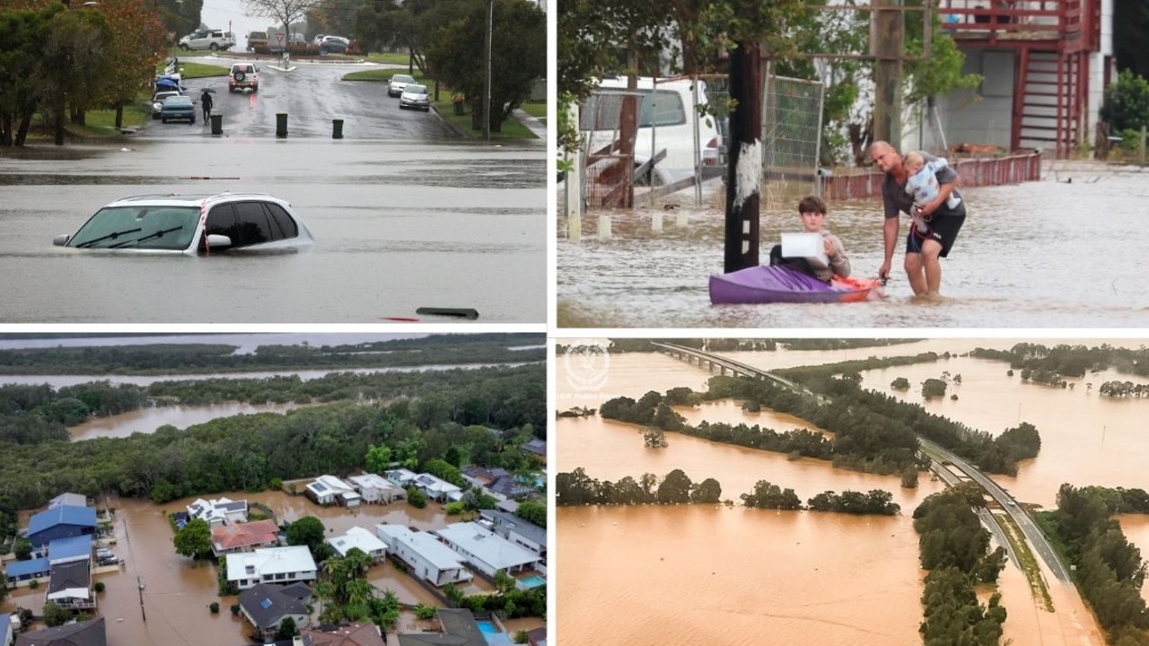
IN PHOTOS: Floods wreak havoc on northern NSW
Extreme weather conditions are lashing the NSW north coast, with 50,000 currently isolated, one person confirmed dead and three others currently missing. Here’s a look at what’s happening on the ground.