
All the walks and waterholes open across the Top End this dry season
A popular water hole has reopened following a croc sighting, joining a growing list of open locations across the Top End. SEE OUR FULL UPDATED LIST.
Northern Territory
Don't miss out on the headlines from Northern Territory. Followed categories will be added to My News.
POPULAR swimming hole and water sports spot Manton Dam has reopened to in-water activities.
The park was closed earlier in the month after a croc was sighted in the region.
The popular spot is well-known to water sports enthusiasts in the Top End attracting wakeboarders and water-skiers most weekends in the dry.
The Department advised people to check its website before visiting any Top End swimming hole and to be CrocWise.
Popular swimming hole opens
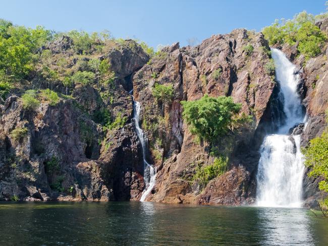
ONE of the Territory’s most popular swimming holes Wangi Falls is ready to reopen, after unprecedented levels of rain saw much of Litchfield closed.
Wangi Falls is one of the Territory’s most popular destinations offering campgrounds and water holes galore for locals and tourists to wade into.
Recent cold weather and rain fall forced the zone to be shut off but from Saturday, July 9 it was ready to reopen once more.
Litchfield National Park ranger Norm Greenfield said the gates were ready to open with a record number of tourists expected to wade into the waters.
“We’re on schedule to open Wangi and once that happens the gates are open and happy days,” Mr Greenfield said.
“This is an unprecedented year, our usual visitor expectations are about 260,000 people a year, but we’re seeing a marked increase which could suggest 10 to 20 percent more on top of that.
“What we’re seeing is campgrounds are full, as is the commercial space so we’re just opening up as many areas as we can as soon as we can.
“Wangi is a great place to take the family for a picnic and have a look around. It’s just a really nice place to come down for the weekend and get out of town.”
However, much of Butterfly Gorge and the Reynolds Track remain closed with more than 40mm of rain falling in the flood plains.
While some portions of the Reynolds Track have been opened, Mr Greenfield expects it will take at least a couple more weeks for a straight run along the track.
“It’s unprecedented weather this year. Last week we had about 40mm of rain, which equates to a lot of rain in flood plain country,” Mr Greenfield said.
“Butterfly Gorge is actually still inaccessible because of the rain at this stage, we’ve done our crocodile surveys and are ready to open, but unfortunately the rain came in.
“That is the same with the Reynolds River Track, we have opened up the northern side of it from Litchfield Park to Sandy Creek and the southern part from Daly River into Surprise Creek.
“But the middle part is inaccessible. We do hope to get machinery out there in the next week or two to have that finished and open to the public to go all the way through.”
DARWIN REGION PARKS STATUS
KAKADU NATIONAL PARK
MAIN ROADS
Arnhem Highway - Open
Kakadu Highway - Open
Old Jim Jim Road - Open
SOUTH ALLIGATOR REGION
South Alligator boat ramp and picnic area - Open
Mamukala wetlands - Open
Kungarre walk - Open
Red Lily Billabong (Djunda) - Open
Bucket Billabong (Ngarrababa) - Open
Alligator Billabong (Gurdurunguranjdju) - Open
Two Mile Hole Billabong - Open 4WD access only
Four Mile Hole Billabong - Closed
Waldak Irrmbal (West Alligator Head) - Closed
JABIRU REGION
Bowali Visitor Centre - Open
Bowali track - Open
Yilikadjarr walk - Open
Malabanjbanjdju campground - Open
Burdulba campground - Open
EAST ALLIGATOR REGION
Ubirr rock art site - Open
Oenpelli Road (at Magela Creek) - Open
Cahills Crossing - Open for vehicle traffic only. Viewing platform closed for infrastructure upgrade, no pedestrian access
Manngarre rainforest walk - Closed
Bardedjilidji walk - Open
Merl campground - Open
Upstream boat ramp - Open
Downstream boat ramp - Open
BURRUNGKUY REGION
Burrungkuy (Nourlangie) rock art site - Open
Nawurlandja lookout walk - Open
Anbangbang Billabong walk - Open
Kubara pools walk (Gubara pools walk) - Open
Nanguluwurr art site walk - Open
Barrk sandstone walk - Open
Sandy Billabong (Djirrilba) campground - Open 4WD only
Bubba wetlands walk - Open. Partially open, follow track markers.
Mirray (Mirrai) lookout walk - Open
YELLOW WATER REGION
Yellow Water (Ngurrungurrudjba) boardwalk - Open
Yellow Water (Ngurrungurrudjba) Boat Cruise - Open
Yellow Water (Ngurrungurrudjba) boat ramp - Open
Home Billabong walk - Closed
Home Billabong boat ramp - Open
Warradjan Aboriginal Cultural Centre - Open
Mardukal (Mardugal) campground one (caravans) - Open
Mardukal (Mardugal) campground two (tents) - Open
Mardukal (Mardugal) Billabong walk - Open
Mardukal Billabong boat ramp - Open
Kungardun (Gungardun) walk - Open
Jim Jim Billabong (Djim Djim Anlabbarl) campground - Open
Jim Jim Billabong boat ramp - Open
JIM JIM AND TWIN FALLS REGION
Karnamarr (Garnamarr) campground - Open Currently high clearance 4WD only
Budjmi lookout walk - Open Currently high clearance 4WD only
Jim Jim Falls (Barrkmallam) - Open Currently high clearance 4WD only
Barrk Marlam walk - Open Currently high clearance 4WD only
Twin Falls gorge - Closed until further notice for infrastructure upgrades
Twin Falls plateau (escarpment) walk - Open Currently high clearance 4WD only
Bilkbilkmi (Graveside Gorge) - Open Currently high clearance 4WD only
MARY RIVER REGION
Gunlom - Closed Cultural closure until further notice
Maguk - Open Unsealed road, 4WD only
Yurmikmik walks - Open Rough surface, 4WD recommended
Kambolgie campground - Open Rough surface, 4WD recommended
Bukbukluk lookout - Open
Gungurul campground - Open
Gungurul lookout and river walk - Open
Jarrangbarnmi (Koolpin Gorge) - Open Access by permit only. Currently high clearance 4WD access only
Guratba/Gimbat day use area - Open Currently high clearance 4WD access only
Igoymarrwa (Ikoymarrawa) rock holes - Open 4WD essential. Camping prohibited
Giyamungkurr (Black Jungle Springs) - Closed
BERRY SPRINGS NATURE PARK
Berry Springs Nature Park: OPEN
Pools: OPEN
All picnic areas: OPEN
Walking track – Loop – Boardwalk: OPEN
BUTTERFLY GORGE NATURE PARK
Status: Closed - due to unseasonal rainfall
CASUARINA COASTAL RESERVE
Walk from Rocklands Drive to Free Beach carpark: OPEN
Walk from Royal Darwin Hospital to Free Beach: OPEN
Sandy Creek Boardwalk: OPEN
Mountain bike trails: OPEN
Lee Point beach picnic area: OPEN
Lee Point walking trail: open
Shared path – Lee Point to Buffalo Creek bird hide: OPEN, with caution, uneven surface along path due to storm damage.
CHANNEL POINT COASTAL RESERVE
Status:OPEN
Bookings required to visit Channel Point Coastal Reserve, even if you don’t stay overnight. You must make a booking online before you travel.
Read more about Channel Point bookings, rules and obtaining the access key.
CHARLES DARWIN NATIONAL PARK
Status:OPEN, Gates are locked at 7pm each day.
Mountain bike trails: Open
DJUKBINJ NATIONAL PARK
Status:OPEN
DOUGLAS RIVER/DALY RIVER ESPLANADE CONSERVATION AREA
Status: Check access with tourist park.
Access via Douglas caravan park. 4WD recommended as only camps one to seven are 2WD. Camps eight to nine are 4WD only. Bookings to camp can be made at Douglas Daly Tourist Park: 08 8978 2479.
FOGG DAM CONSERVATION RESERVE
Fogg Dam Conservation Reserve: OPEN
Monsoon Walk: OPEN
Woodlands to Water Lilies Walk: OPEN
Damn Wall Walk: OPEN
GARIG GUNAK BARLU NATIONAL PARK
Garig Gunak Barlu National Park: CLOSED, out of respect for the passing of a senior Traditional Owner of the area.
Coburg Marine Park: OPEN
GEORGE BROWN BOTANIC GARDENS
George Brown Botanic Gardens:OPEN
Visitor and Events Centre and gift shop: OPEN
Children’s playground: OPEN
HARRISON DAM CONSERVATION AREA
Harrison Dam Conservation Area: OPEN
Harrison Dam Wall Track: CLOSED
HOLMES JUNGLE NATURE PARK
Holmes Jungle Nature Park: Open
Top Road, including front gate access: Open
Woodland Walking Tracks: Open
Jungle Walk in Monsoon Forest: Open
Hilltop Picnic Area: Open
Bottom Road (dirt road): Open
HOWARD SPRINGS HUNTING RESERVE
Howard Springs Nature Park: OPEN
Rainforest Walk (Howard Creek Walk): OPEN
Springs walking track: OPEN
East Picnic Area: OPEN
Western Picnic Area: OPEN
Rock pools: OPEN
Toddler pool: OPEN
KNUCKEY LAGOONS CONSERVATION RESERVE
Knuckey Lagoons Conservation Reserve: OPEN
LEANING TREE LAGOON NATURE PARK
Leaning Tree Lagoon Nature Park: OPEN
LITCHFIELD NATIONAL PARK
All roads into the national park are open.
BAMBOO CREEK TIN MINE
Bamboo Creek Tin Mine: CLOSED
BULEY ROCKHOLE
Buley Rockhole: OPEN for swimming.
CASCADES
Lower section swimming: OPEN
Upper section swimming: OPEN
Cascades Loop Walk: OPEN
CENTRAL VALLEY
Campground 1: OPEN
Campgrounds 2: OPEN
Campgrounds 3: OPEN
FLORENCE FALLS
Florence Falls Lookout: OPEN
Swimming: OPEN
Shady Creek Walk: OPEN
Florence Creek Walk: OPEN
2WD campground: OPEN
4WD campground: OPEN
GREENANT CREEK
Greenant Creek walk: OPEN
REYNOLDS RIVER TRACK
4WD track access only.
Reynolds River track: CLOSED, between Sandy Creek Falls sand Suprise Creek Falls
Blyth Homestead: OPEN
Sandy (Camp) Creek Falls: OPEN
Surprise Creek Falls: OPEN
THE LOST CITY
4WD track access only.
The Lost City: OPEN
TABLETOP TRACK
Tabletop track access: Partly Open
TOLMER FALLS
Tolmer Falls access: OPEN
WALKER CREEK
Walker Creek: OPEN
WANGI FALLS
Campground: OPEN
Loop walk: CLOSED, due to wildfire
Picnic area: OPEN
Cafe: OPEN, Cafe is open for takeaway only, 11am to 2pm daily – for information about the cafe, go to the Wangi Falls Cafe website.
Swimming: OPEN
MANTON DAM RECREATION AREA
Manton Dam Recreation Area: OPEN
Dam: OPEN
MARY RIVER NATIONAL PARK
Mary River National Park: OPEN
Mary River Billabong: OPEN
Bird Billabong Day Use Area: OPEN
Bird Billabong Walking Track:OPEN, Return walk to bird hide only. Loop walk remains closed.
Brian’s Creek Monsoon Forest Walk: OPEN
Hardies 4WD Track: Partially Open
Jimmy’s Creek Monsoon Forest Walk: OPEN
Mistake Billabong: OPEN
Rockhole Road: OPEN
Couzens Lookout and Campground: OPEN
North (Wildman) Rockhole: OPEN
Wildman 4WD Track: OPEN
Shady Camp Campground: OPEN
Shady Camp crocodile viewing platform: OPEN
Point Stuart Coastal Reserve: CLOSED, road works
Point Stuart Coastal Reserve Walking Track: CLOSED
Stuarts Tree walking track: CLOSED, road works
SHOAL BAY COASTAL RESERVE
Shoal Bay Coastal Reserve: OPEN
TERRITORY WILDLIFE PARK
Territory Wildlife Park: OPEN
Cafe: OPEN
TJUWALIYN (DOUGLAS) HOT SPRINGS PARK
Tjuwaliyn (Douglas) Hot Springs Park: CLOSED, his park is closed due to water supply issues. We are working with Traditional Owners and the Northern Land Council to resolve these issues. To find out more about this, go to the Department of Environment, Parks and Water Security website.
Swimming: CLOSED
Campground: CLOSED
TREE POINT CONSERVATION AREA
Tree Point Conservation Area: OPEN.
UMBRAWARRA GORGE NATURE PARK
Umbrawarra Gorge Nature Park: OPEN
Swimming: OPEN
Campground: OPEN
More Coverage

Originally published as All the walks and waterholes open across the Top End this dry season
Join the conversation

NT anglers: Have you got plaice in your heart for someone special?
Fishing fanatics who want to be on line instead of online are getting the chance to find someone shrimply irresistible or new friends at a weekend away at Dundee Beach.
Read more

Absolutely Fabiola: The sounds of Italy on our airwaves
Charles Darwin University (CDU) student Fabiola Del Signore is sharing her love of Italian music and culture with the Top End, launching her first radio show on Territory FM this month.
Read more