Why we should pay attention to this map
The outlook for Australia’s severe weather season has several warnings for the next few months — but this is the map that reveals just how tough things might get.
National
Don't miss out on the headlines from National. Followed categories will be added to My News.
Floods in Sydney, Brisbane and the Murray-Darling Basin; extreme heatwaves in Adelaide and Perth; more tropical cyclones. Strap in, Australia, because this severe weather season could be an absolute shocker.
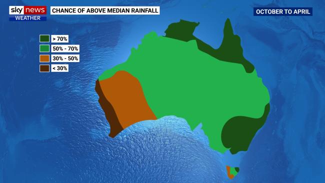
According to Sky News Weather’s latest outlook, to be released on Thursday, eastern Australia could experience more widespread flooding in the 2022/23 severe weather season (October to April), with Sydney, Melbourne, Brisbane, Darwin, Hobart and Canberra all expected to get above average rainfall.

Sky News meteorologist Alison Osborne said the rainfall outlook for the upcoming season was similar to last year, but the risk of flooding was much greater.
“Last severe weather season we had very dangerous and prolonged flooding in some areas and quite significant rain events and what that has done is that it has filled dams to capacity. They are at 96 per cent across the Murray Darling basin, and a number of dams in eastern Australia are at capacity,” Ms Osborne said.
“(If we get) the same amount of rainfall over the same areas this severe weather season, the impacts are likely to be worse, because the landscape is already completely waterlogged.”

The Sky News outlook predicted water flows over the Murray-Darling Basin could be the highest in half a century, and NSW, Victoria and Queensland are all at heightened risk of flooding.
With the Warragamba Dam sitting at near 100 per cent capacity, Greater Sydney was at risk of major flooding, while Brisbane’s Wivenhoe dam was above 90 per cent, compared to 40 per cent this time last year, the Sky News outlook stated.
Ms Osborne said Sydney was likely to have its wettest year on record in 2022 (with rainfall records stretching back to the 1800s, it’s already in the second top spot), while it was “not out of the question” Brisbane could have its wettest year on record too, although a lot more rain had to fall for that record to be broken.
The outlook also predicted a more active season for tropical cyclones.
In recent years Australia had seen nine or ten tropical cyclones per season, with sometimes just one making landfall, but this coming season could see as many as 14 systems forming, and as many as four or five could make landfall, Ms Osborne said.
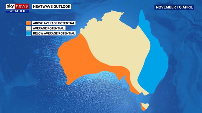
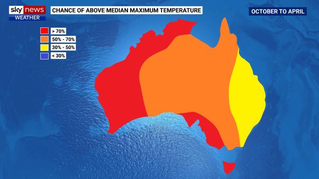
While the eastern half of the country is likely to be waterlogged, Western Australia and parts of the southern states could be baking in extreme heatwaves, the outlook suggested.

Melbourne, Adelaide and Hobart are all tipped to be warmer than they were during the 21/22 severe weather season, while Perth could be in for a scorcher to match last year’s record-breaker.
In mid to late summer there would be a “very high risk of extreme heat over in the west, much like we saw in Perth in Christmas,” Ms Osborne said.
Last year’s severe weather season saw Perth break the record for most consecutive days over 40 degrees (six), while on January 12 the town of Onslow in northwest WA equalled the record for Australia’s hottest-ever daily maximum (50.7 degrees).

In one bit of encouraging news, Ms Osborne said the La Nina conditions “should taper off in summer”.
This forecast was backed up by the Bureau of Meteorology’s latest climate driver update, which said La Nina conditions “may peak during spring and return to neutral conditions early in 2023”.
Watch Sky News Weather, Foxtel channel 601, for all your latest weather updates and news.
Originally published as Why we should pay attention to this map


