
Heatwave set to reach its peak but cool relief will only be brief
Thought it was hot? Guess again. We’re about to reach peak heatwave. Relief is coming — but not for long.

Heat records have been falling but forecasters have warned the worst is yet to come in Australia’s scorching summer heatwave.
New South Wales is likely to be particularly badly hit with the mercury climbing today and the peak of the blistering temperatures coming on Friday when parts of Sydney could touch 45C.
Rail commuters have been warned that tracks could buckle under the intense conditions
In the worst-affected areas, temperature are 10 to 14 degrees higher than average for this time of year.
MORE NEWS:
How sleazy NSW teachers hit up students online
Wannabe $100m Powerball winner must read this
Man charged with drug supply may be linked to Alex
Meanwhile Melbourne, which so far has managed to escape the worst of the heat, is about to get a blast of scorching highs with the temperature shooting up to 40C in the suburbs.
A cool change is scheduled to sweep through the south east from Friday. But the mercury won’t dip for long. From early next week the heat will start rising once more, first bringing scorching conditions to Perth and then to the southeast once more.
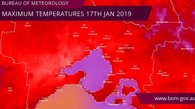
Yesterday, the Bureau of Meteorology (BOM) said the previous four days had been in Australia’s top 10 warmest days on record.
Nine areas of NSW broke temperature records, including six records since observations began.
White Cliffs in the state’s northwest recorded the highest temperature in NSW and an all-time high for the area with 48.2C just before 3.30pm.
In South Australia, Tarcoola surpassed 48C on Wednesday.
Extreme heatwave conditions, which are risk to even fit and healthy people, continue across central and eastern NSW and the north of Victoria including Canberra and western Sydney.
Sydney’s CBD is looking at a high of 32C today and 34C on Friday. It’s way hotter out west though with Penrith on 41C today and 45C on Friday.
Wagga Wagga could see 44C for the next two days with Ivanhoe, in the state’s far west, surpassing 48C.
NSW Energy Minister Don Harwin said energy demands during the next few days will be met and residents shouldn’t be worried about using airconditioners.
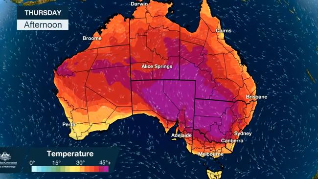
Very hot, dry and windy conditions were predicted to generate elevated fire dangers into Thursday. Total fire bans are in place for the central ranges, northwestern and southern slopes areas of NSW.
Canberra is facing yet another 40C-plus day on Thursday with the mercury getting as high as 41C and then 40C on Friday.
In Victoria, the Bureau has warned the sea breezes that have so far ensured Melbourne’s CBD has been sheltered from the weather’s worst excesses may not play ball on Thursday.
Highs of up to 37C in the CBD and 40C at Avalon are higher than initially forecast, due to reduced afternoon cloud cover and fresh westerly winds limiting the effectiveness of the sea breeze.
Bendigo will see 38C and Mildura will get as high as 45C as inland Victoria bakes.
In Adelaide, it will be a toasty 37C. Further north in Port Augusta expect a high of 47C.
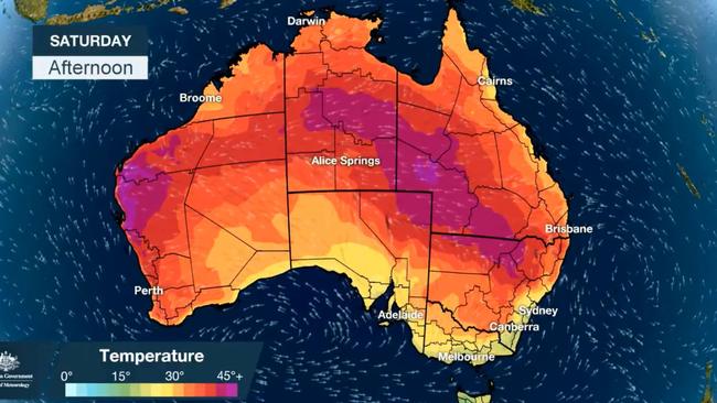
COOL CHANGE, BUT BRIEF
Relief is coming, said Sky News Weather channel meteorologist Rob Sharpe — but it won’t last long.
“On Friday, when the cool change sweeps across South Australia and Victoria, temperatures will drop markedly,” he said.
Melbourne CBD will ease to a high of 28C and then just 23C on Saturday. That cool change will take until Saturday to reach across the Murray with Canberra turning a high of 40C on Friday to a mild in comparison 33C on Saturday.
Sydney’s CBD should see 28C on Saturday and just 26C on Sunday.
“On Sunday, over in (Western Australia), that heat will only just be starting to ramp up in Perth and the inland areas of Australia,” Mr Sharpe said.
“On Tuesday, that heat starts flooding straight back into the southeast.”
Sure enough, Perth could reach 40C by Sunday and Adelaide could be close to 40C again by mid next week.
Melbourne should escape the worst but inland the 40s will again be a feature of next week in Victoria.
This time next Wednesday, western Sydney could be on 41C.
Expect temperatures of around 25C for the next few days in Hobart. Brisbane continues its run of sunny days in the low-30s. Perth will see a mild 26C on Thursday before it begins creeping into the 30s and the 40s over the next few days. Darwin is 34C and partly cloudy with the possibility of storms.
Download The Daily Telegraph and Sunday Telegraph app for your smartphone or tablet to get the full story.
APPLE: DOWNLOAD THE APP FOR iOS
GOOGLE PLAY: DOWNLOAD THE APP FOR ANDROID

WHAT YOU GET WITH OUR APP
► Live and latest news — Get the news as it breaks 24-hours a day, 7 days a week
► My News — Your own personal news feed. Tailor your news to get straight to the topics that matter to you
► Today’s Paper — Read the paper anytime, anywhere with the digital replica of the paper, as its printed
► Notifications — Be the first to know when big stories break with instant news alerts straight to the locked screen on your smartphone and tablet
► Live Sport Scores — Stay on the ball with NRL and AFL live sport scores and expect analysis
► Share — Join the conversation and share your favourite stories via Facebook, Twitter or email
► Daily puzzles — With new crosswords and Sudoku puzzles every day, there’s always something to keep your mind active
► Subscribe — Through the app (via iTunes) to start your 30-day FREE trial; then your subscription will automatically renew to $29.99 per month.

The making of a criminal mastermind
The only police officer to fire a shot at Bassam Hamzy recently revealed for the first time how he could have ended the notorious gangster’s bloody reign 20 years ago.
Supermarket workers face random COVID-19 tests
As Australia looks to expand its coronavirus testing regime, random tests could be rolled out for people living and working in high-risk areas, including supermarkets.